
|
Unknown County FLGenWeb | Counties | County Map | FLGenWebArchives | FL Societies | Special Collections | Volunteer | MAPS
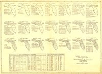
This was a favorite map of one of our former
state coordinators, Patrice Green. Actually it is a series of
maps showing the Development of Florida Counties from 1820 to
1936.
The map is located in the University of Florida, George Smathers Libraries, Map Collection. It is from the Florida Works Progress Administration and assembled by the Historical Records and State Archives Surveys. Click on the image to view the original. This link goes to a Broward County Library Digital Archives page. The document is in four (4) parts. Very interesting map. 
More MapsUniversity of FloridaP. K. Yonge Library of Florida History University of South Florida Historic Florida Maps 1895 Atlas Maps for the State of Florida and Individual Counties These maps are just plain beautiful! 1895 Atlas Maps for Florida
(c) 1996 - Present | last updated July 2021 FLGenWeb state site, background, logo & banner created & courtesy of Jeff Kemp |
