

Sagadahoc County
MEGenWeb

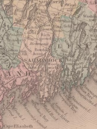
1855
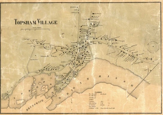
1858 Topsham Village
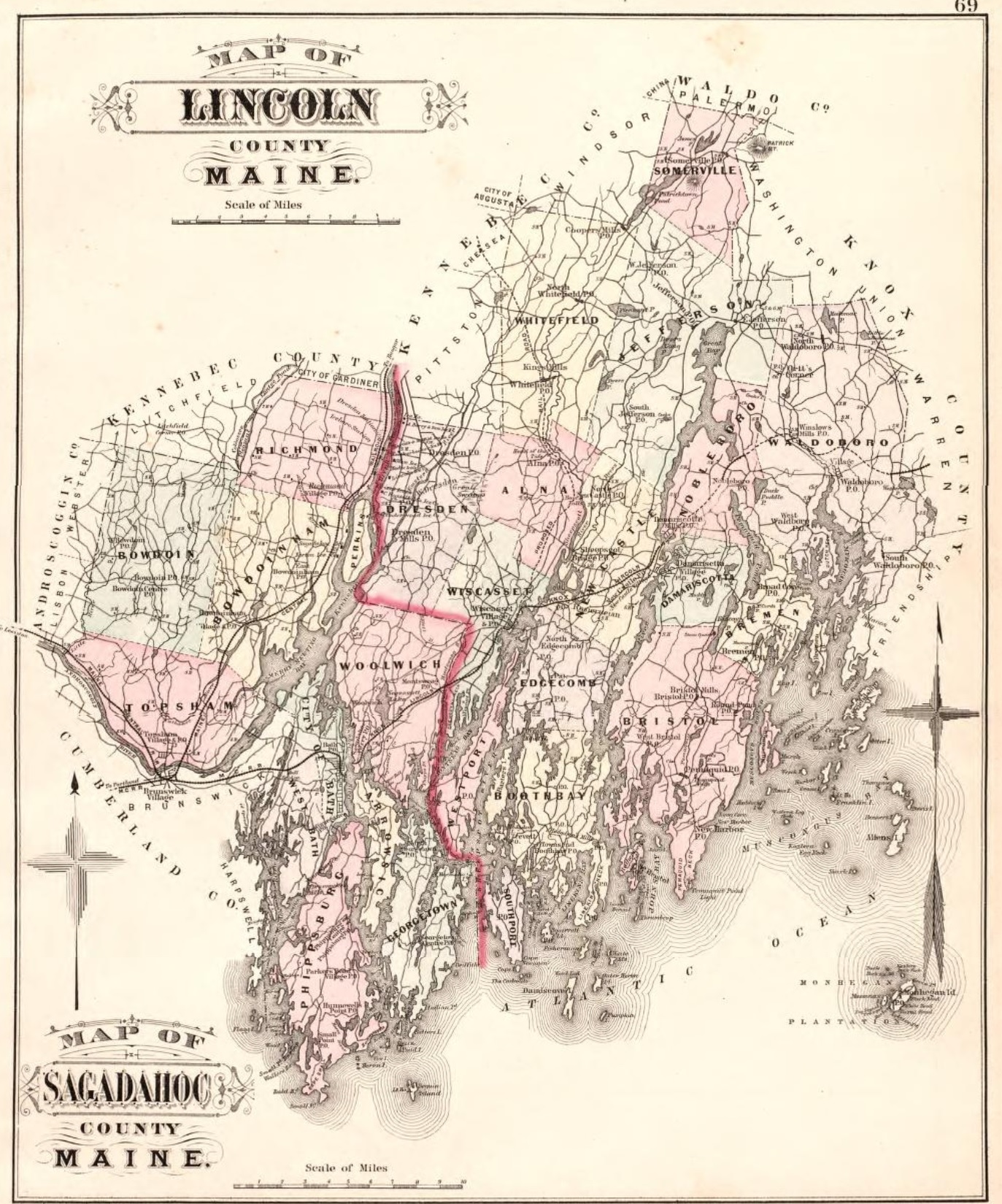
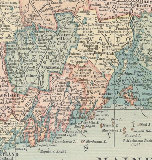
1886 Sagadahoc & Lincoln Counties
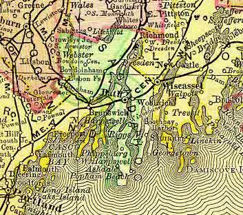
1895
1910
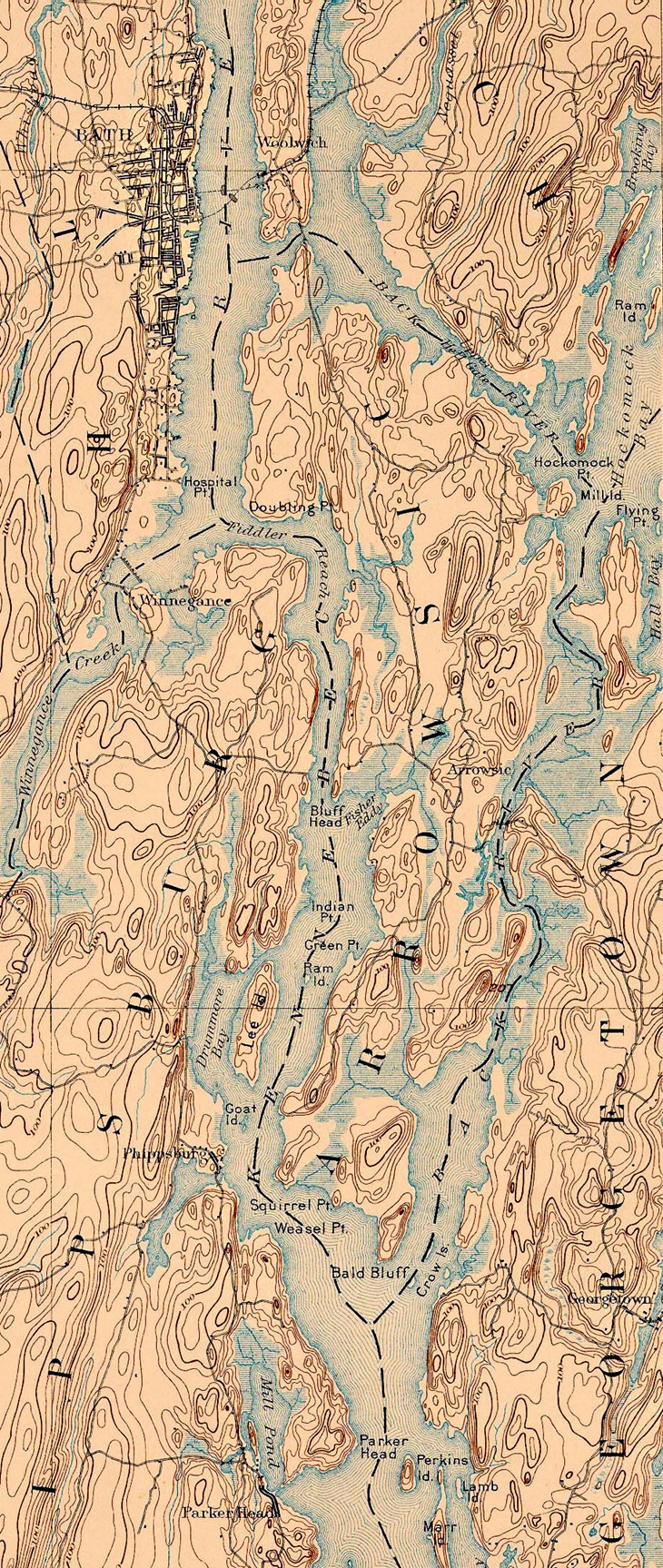
Arrowsic
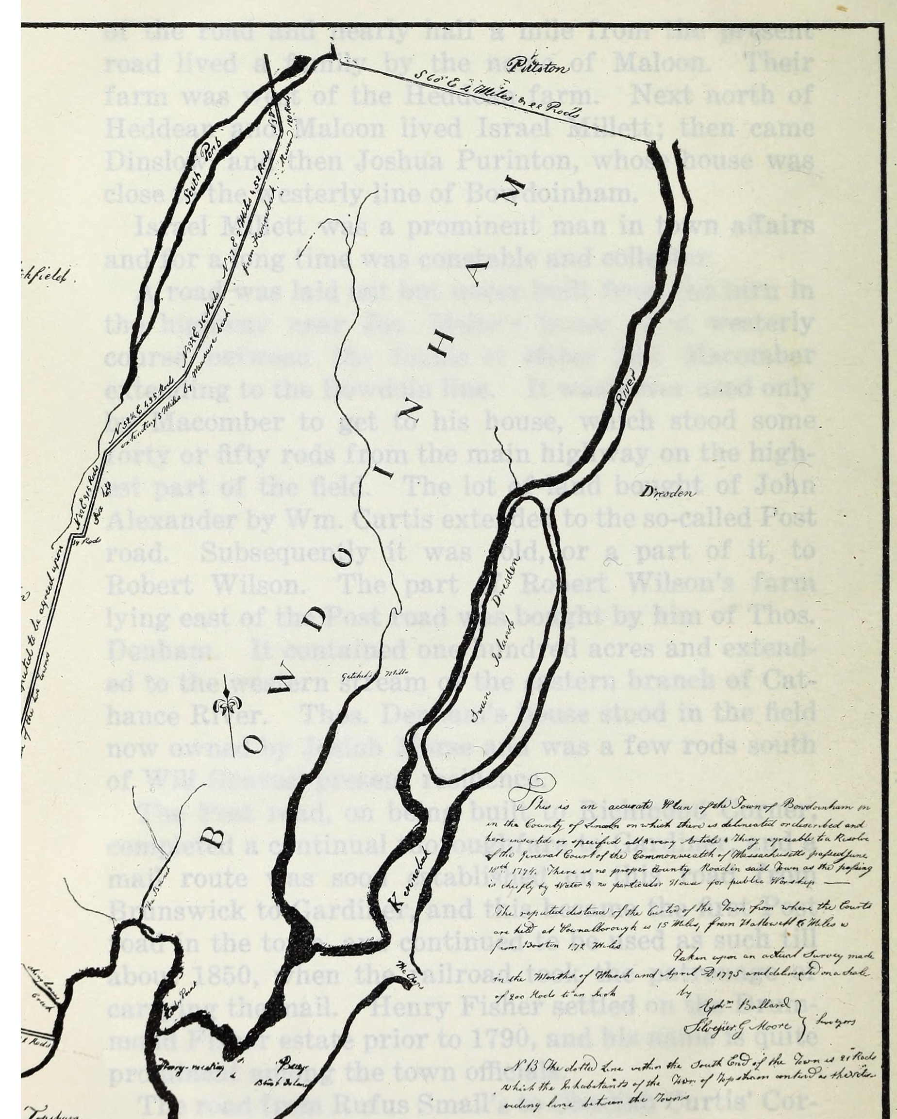
1795 Bowdoinham
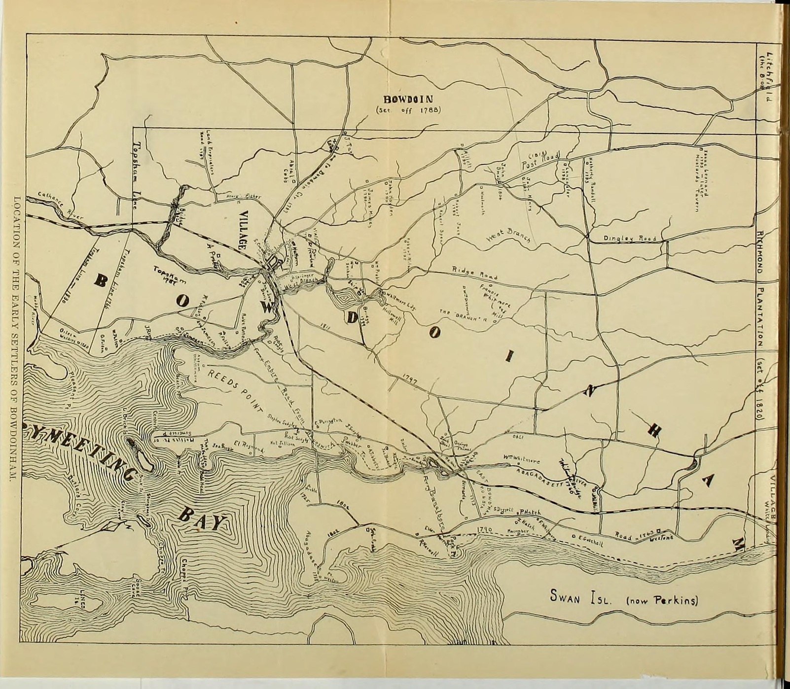
Bowdoinham Early Settlers
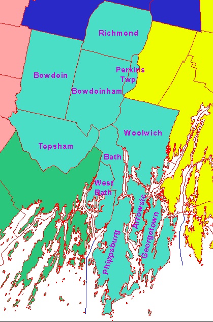 Sagadahoc County is located in the midcoast region of Maine. It is made up of
twelve communities totaling 250 square miles, with a population of approximately
33,525. The county is rich in Maine history. Bath, the county's only city, is
world famous for its shipbuilding and home to Maine's largest employer, Bath
Iron Works, Inc. and a close neighbor to the nationally-known Bowdoin College.
Phippsburg and Georgetown date back to the early 1600s and may very well be
Maine's best kept secrets of paradise, stretching down a long peninsula not far
from Portland. Bowdoinham, Richmond, and Topsham are growing communities because
of their competent work force. Sagadahoc County is a popular area for tourists,
offering phenomenal coastline, a rich maritime heritage, quaint towns, antique
shops, and much, much more.
Sagadahoc County is located in the midcoast region of Maine. It is made up of
twelve communities totaling 250 square miles, with a population of approximately
33,525. The county is rich in Maine history. Bath, the county's only city, is
world famous for its shipbuilding and home to Maine's largest employer, Bath
Iron Works, Inc. and a close neighbor to the nationally-known Bowdoin College.
Phippsburg and Georgetown date back to the early 1600s and may very well be
Maine's best kept secrets of paradise, stretching down a long peninsula not far
from Portland. Bowdoinham, Richmond, and Topsham are growing communities because
of their competent work force. Sagadahoc County is a popular area for tourists,
offering phenomenal coastline, a rich maritime heritage, quaint towns, antique
shops, and much, much more.
Sagadahoc became a county in 1854 and was
originally part of Lincoln County. The name Sagadahoc is said to have come from
the Sasanoa Indian Tribe and roughly translated means "mouth of big river,"
referring to the Kennebec River. Sagadahoc County was most likely named for the
Sagadahoc expedition of the early 1600s, which included the Popham Colony at the
point of what is now Phippsburg.
The towns of Bath, West Bath,
Phippsburg, Arrowsic, and Woolwich were originally part of Georgetown, each
being set off at various times. Individuals conducting research in these towns
may want to check the Georgetown records for extra measure. Records have also
indicated that a portion of Woolwich was also part of the old town of
Pownalborough; these records can be found in Dresden, Maine.
Arrowsic
Arrowsic is a town and an island situated in the Kennebec River near its mouth. The small portion of the Kennebec that turns eastward around this island, then southward between Georgetown and Arrowsic, is called Back River. On the north of Arrowsic is Woolwich, on the west of the northern part is Bath, and west of the southern is Phippsburg. The island is nearly seven miles in length from north to south, and averages about one mile in width, containing some 5000 acres. There is a considerable hill at the southern part, and the middle of the island is generally highest, but the elevation is small. The southern point bears the name of Bald Head. There is very little marsh, several inlets, and near the middle of the island is Sewall's Pond, a sheet of fresh water about three-fourths of a mile long and one-fourth wide. Fisher's Eddy, near the middle of the western side, forms a small harbor. At one time, iron ore was found on the island and a mineral was for some time mined here, which was ground in a crushing mill at Bath, for use as a substitute for emery in grinding and polishing metals. The town had four saw mills, all operated by tide power.
This island was purchased from the Indians by Major Clarke and Captain Lake in 1661. At this time there was a fort on the west side of Arrowsic or of Woolwich, which was occupied by one Hammond, an old Indian trader. This fort was captured in August of the second year of the first Indian war by the treachery of some squaws, who begged for, and obtained, lodgings within it. The resentment of the Indians is said to have been directed against this place on account of the loss of furs and arms stolen by the English from some of their tribe. On Arrowsic Island, about two miles distant from Hammond's, Clarke and Lake had constructed a larger and stronger fort. They had also in the vicinity a mansion house, mills, outbuildings, cultivated fields, and domestic cattle. This flourishing establishment was surprised and destroyed in the same incursion and by the same Indians who destroyed Hammond's. Captain Lake, in attempting to escape, was mortally wounded. In answer to a petition of 26 men in their behalf, in 1679 Governor Andros assigned to them the lower part of Arrowsic for a compact settlement. Here they established themselves and built a fort, naming the place Newtown. In 1689 this settlement was burnt by the Indians with the exception of a single house. Again, a short time before the building of Fort Halifax on the river opposite the present Waterville, the Norridgewock Indians made a descent upon Arrowsic, killing a Mr. Preble while he was at work in his field. They then proceeded to his house, murdered his wife, and took his children (a son and two daughters) to Canada. After peace was made in 1763, Captain Hamden, a relative of the Prebles, visited Canada and obtained the release of the children. The island was three times (in 1676, 1689, and 1722) swept nearly clean of inhabitants by the Indians. Remains of cellars and dwellings are still to be seen as memorials of the pioneers and of Indian savagery.
Arrowsic was originally embraced in Georgetown, but in 1841 it was set off and incorporated under its present name. The first known house of worship in the Sagadahoc region was erected, probably about 1660, at the northern point of the island. In 1761, the meeting house of the first parish of Georgetown was bult in the southern part. The present house of worship in Arrowsic belongs to the Methodists. Arrowsic has two schoolhouses.
Bath (county seat)
Bath is known as "The City of Ships;" a proud city with a lot of heritage and life. Bath is one of the most populated cities in Maine. It was named for the famous watering place of English Avon - Bath, England. For this name, the city is indebted to Dummer Sewell, Esq., Bath's first postmaster and a representative in the General Court. Bath got its nickname from its long history of shipbuilding and fishing and the first ship ever built in the New World was constructed about 15 miles from Bath at the Popham Colony, the first attempt at a permanent settlement in the area in 1607 at the mouth of the Kennebeck River. This settlement failed due to lack of leadership and harsh weather. The surviving settlers sailed back to England the following year, some of them aboard the pinnace Virginia, the first seagoing vessel built in North America by Englishmen.
The area that now encompasses Bath, Maine, is believed to have been first inhabited by the prehistoric Red Paint people, then subsequently by the "People of the Dawn," the Abenaki Indian nation within the Algonquin group. Viking explorers may have visited the Maine coast and rivers early in the eleventh century, followed later on by European fishing parties. A progression of expeditions then occurred, each looking for wealth and a short passage to the Indies. In 1605 Captain George Weymouth sailed along the coast and Samuel de Champlain went up the Kennebec River to the area that is present-day Bath.
Bath is situated on the Kennebec River (in Abenaki means "long level water") near the center of Sagadahoc County. Woolwich and Arrowsic - both separated from Bath by the Kennebec River - bound it on the east; West Bath, Brunswich (in Cumberland County), Topsham, and Bowdoinham lie on the west - the latter two being separated from Bath by Merrymeeting Bay; and West Bath and Phippsburg lie to the south. The town lies on a long peninsula along the Kennebec River from north to south, is about five miles long and its average width is about 1-1/2 miles; hence, the nickname in the 1600s of "Longreach."
During colonial times, Bath and other present surrounding towns (West Bath, Woolwich, Arrowsic, Five Islands) were referred to as The Parish of Georgetown. Just at the time when Greene was campaigning against Cornwallis in the Carolinas, the Parish petitioned to be made a town and, in 1781, incorporated as Bath. Bath was the first town incorporated after the new constitution of Massachusetts was adopted. In 1844 the southwestern portion was set off as West Bath; in 1847 Bath received a city charter; and on the establishment of Sagadahoc County in 1854, Bath became the county seat. Shortly thereafter, western residents of Bath formed West Bath, and in recent times, West Bath has become a municipality.
The Carlton Bridge, one of Bath's oldest landmarks, was built over 75 years ago, to permit trains to pass over the Kennebec River instead of being ferried across. The Carlton Bridge's replacement is now completed and the old bridge is coming down. It will probably (according to rumor and recent newspaper articles) be named The Sagadahoc Bridge for the county where it is located.
Every community along Maine's southern coast has its own tradition of shipbuilding and fishing; however, the best can be realized at Bath. Of the many shipyards, the Percy & Small Shipyard was the last surviving one to build large wooden sailing vessels and its buildings. With the acquisition of the Percy & Small Shipyard acreage on the south side of the City in 1971, the Maine Maritime Museum has preserved the State's shipbuilding heritage exactly as it was for hundreds of years. In 1964 the Marine Research Society of Bath (formed in 1962) opened a storefront exhibit to the public. In that same year, the Sewall House at 963 Washington Street was donated to the Society, which was reorganized as the Bath Marine Museum, and in 1989 became the Maine Maritime Museum. The earliest recorded shipbuilding venture in Bath was in 1743 by Jonathan Philbrook and his sons, who built two vessels in the vicinity of present-day Lambard Street. Another pioneer in the shipbuilding industry of Bath was Captain William Swanton, a soldier in the French wars, who served in the reduction of Louisburg in 1758. In 1762 he established a commercial shipbuilding business and built a ship each year for 15 years, up to the year 1776.
The Bath Iron Works (affectionately called the "BIW"), Maine's largest private employer, is located in Bath and has been in business for over 100 years. Originally named the Bath Iron Foundry, the BIW has a proud history of making seaworthy vessels for the U.S. Navy. During WW-II, the BIW built more ships than the entire Japanese Navy had, launching a new ship every 17 days. The BIW is currently constructing the Arleigh Burke Class Aegis Destroyers for the U.S. Navy.
Another eminent citizen, also engaged in shipbuilding and a great promoter of commerce, was William King, who later became the first Governor of Maine when Maine became the 23rd state admitted to the Union in 1820. King also led the local militia during the War of 1812 with England. Dummer Sewell (mentioned above) served during the American Revolution and when news came about the battles of Lexington and Concord, he led a group of men to North Bath to stop British workers from chopping down trees for British ship masts.
Bath has changed in many ways during its existence, but the community still cherishes its valuable heritages from the past. The results of Bath shipbuilding can be seen throughout the City. Self-guided walking and driving tours are available from Sagadahoc Preservation, Inc., that includes the Customs House (built in 1858), the Chocolate Church (built in 1847), and a visit to the Patten Free Library (built in 1889) where the Sagadahoc History and Genealogy Room, operated and maintained by the Bath Historical Society, is located. This room contains an abundance of genealogical research materials and is used by researchers from the US and Canada.
Bath provided many of its sons (and daughters) to the defense of home and country. Henry Wilson Owen in his History of Bath, Maine (pp 501-526, published by the Bath Area Bicentennial Committee 1976) provides an excellent accounting of military history for Bath beginning with the Second Parish Company, organized almost as early as the town itself, up through WW-I. During the Civil War, Bath sent 765 soldiers to aid the Government in the preservation of the Union, of which 117 are known to have been lost; a monument was later erected to commemorate this sacrifice in the city park.
Bowdoin
Bowdoinham
Bowdoinham, located on Merrymeeting Bay and the Kennebec River, was named for Dr. Peter (or William) Bowdoin, a French refugee who came to America in 1685. The following brief history is taken in part from an essay written by a local Bowdoinham student...
Bowdoinham was incorporated as the 14th town in the Province of Maine in September, 1762. Local traditions tell of settlers within the present limits of the town as early as 1623, and there are records establishing settlers in the area in the late 1600s and early 1700s. Bowdoinham's first settlers lived on the points of Merrymeeting Bay and on the western shores of the Kennebec and Abagadassett Rivers. Settlers occupied the area at various times and were driven off by Indians several times before permanent footholds were established in the 1730s.
In 1765, townspeople built a crude meetinghouse on ledges overlooking the Abagadassett River. In 1775, however, all of the colonies were in the throes of a rebellion against the King, and the town's first church caught fire and burned to the ground, reportedly torched by Tories in the area who were still loyal to the Crown. In its original charters, Bowdoinham included all of present-day Richmond and portions of present-day Topsham and Bowdoin. Bowdoin was incorporated as a town in 1788, and Richmond -- called White's Landing in those days -- was set off from Bowdoinham in 1823. Excluding a series of boundary disputes with Topsham over the Bay Road area of town -- then called Cathance Neck -- Bowdoinham town limits have remained essentially unchanged since the 1820s.
Bowdoinham was one of the earliest shipbuilding centers on the Kennebec River, and for several years around the 1850s, was a leader of that industry. The first vessel built in Bowdoinham was launched in 1768, well before the American Revolution, and the last known vessel of any size was launched in 1912. In all, more than 250 vessels were constructed in Bowdoinham.
Bowdoinham Village (known as Cathance Landing in the early days) wasn't settled until 1800; but the small landing developed very quickly into a bustling center for trade, providing the closest tidewater access for the inland towns of Lisbon, Bowdoin, Webster (present-day Sabbatus), and even Lewiston. By 1810, warehouses and mills lined both shores of the Cathance River; the bridge across the river to Topsham was built as a toll bridge; and the development of Patten's Woods -- soon to be "Brooklyn" -- was underway. Boarding houses, two hotels, and more than two dozen stores, businesses and manufacturing operations shared Main Street frontage with private homes, estates and churches.
For several decades, Bowdoinham rode its shipping industry to unparalleled prosperity. The town's population peaked with the 1850 census at 2,382. The 1860s brought America to near-ruin during the Civil War, and Bowdoinham declined into a depression from which it never fully recovered. Young men went off to war and settled in the south and west when the conflict ended. Advances in the shipbuilding trades made the ships of Bowdoinham obsolete, and the town that helped foster the State's shipbuilding industries had to stand aside helplessly and watch her master builders and seamen pack their tools and move to shipyards and towns with wider rivers and the ability to build ever bigger ships. Bowdoinham's only bank was robbed in 1867, and much of the Town's remaining fortunes were wiped out. More than $73,000 was taken and never recovered.
By the 1870s, Bowdoinham reverted to what it had always been at the grassroots: a small, agriculturally-based community of self-sufficient farms. Residents raised market crops of apples, wheat, hay, and potatoes; they harvested fish and ice from the rivers; and wood from the forests, earning a decent -- if not extremely profitable -- living. When the Kendall brothers came to town, their sheep-raising, grain, and fertilizer businesses spurred new industry. This enterprise would rise with the fortunes of the state's agricultural tide, only to be squashed by the depression of the 1930s.
In 1902, on the evening of December 14, fire swept unchecked through the heart of the business district, destroying nearly all of it. Fire struck again in March 1904, burning another section of Main Street.
"The History of the Town of Bowdoinham 1762-1912" by Silas Adams, which includes 100 photos, portraits, and an 1858 map, is the most definitive account ever published of this important Sagadahoc County community.
Georgetown
Georgetown is an island and a town, forming the southeastern part of Sagadahoc County, lying between the Sheepscot River and the mouth of the Kennebec River. Westport and Woolwich lie on the north, Arrowsic and Phippsburg on the west. The town formerly embraced the several islands at the mouth of the Kennebec, together with what are now the towns of Phippsburg, Bath, West Bath, Woolwich, and Arrowsic. It now includes only one island, formerly called Parker's Island. This was purchased of the natives in 1650 by one John Parker, who was the first occupant after 1668, yet it has been thought by some that a portion of Popham's Colony formed a settlement here. The island is presently held under Parker's title, some of his posterity still being residents and land proprietors. The Indian name of the island was Rascohegan, with various spellings. The southern part is the locality known to early voyagers as Sagadahoc. The first Indian war swept away whatever inhabitants there were and no permanent resettlement was made until about 1730. It was included in the incorporation of 1716.
Perkins Township
Perkins Township lies in the Kennebec River between Richmond on the west bank and Dresden in Lincoln County on the east. Its length is about 3-1/4 miles and 4-1/4 in width. It bore the name of Swan Island almost from the time when it was first known until its separation from Dresden and incorporation under its present name in 1847. It lies 14 miles north of Bath, on the line of the Kennebec, Portland, and Boston steamers. The nearest railroad station is at East Bowdoinham for the southern part and Richmond village for the northern. The town is mostly level, well-wooded, and fertile. When first discovered by Europeans, the island was the residence of Sebenoa, the sachem of the lower Kennebec. In 1692, Colonel Church and his men had a conflict with a large body of savages at this place, in which the Indians were routed, some escaping to the mainland, and some to their fort at Teconnet, near Waterville. The post office for the town is Richmond and it has one public schoolhouse.
Phippsburg
Phippsburg constitutes the southern point of Sagadahoc County and lies between the Kennebec River on the east and New Meadows Harbor and West Bath on the west. On the opposite side of this harbor is Great Island, a part of Harpswell; on the eastern side are the island towns of Arrowsic and Georgetown; Bath lies at the northwest. Phippsburg is very nearly 12-1/2 miles in extreme length and has an average width of about 3 miles, with bays and inlets marking its entire circumference.
Following the shore northeastward from Cape Small Point, is the inlet known as Sprague's and Morse's Rivers, succeeded by Hunniwell's Beach; north which Hunnewell's Point and Sabino peninsula form the eastern shore of Atkins' Bay. On its northern side rises the lofty bluff of Coxe's Head, upon which, in 1814, an earthwork was erected; beyond which is Wyman's Bay. At the north looms Parker's Head, and at its southwestern side is the inlet basin forming the tide-power known as Parker's Head Mill Pond. Next is the harbor at Phippsburg Center, with Drummore Bay two miles above with inlet and tide-power. Through Fiddler's Reach, a curve of the Kennebec around the northern end of Phippsburg, is Winnegance Creek, nearly three miles in length and a basin at its extremity, forming two unsurpassed tide-powers, and separating Phippsburg from Bath and from West Bath, except for a neck 200 rods in width, the Winnegance Carrying Place. South of this is the Western Basin, Horse Island Harbor, Small Point Harbor, and several others. There is some sale meadow in the northern part and the insulated ponds are Cornelius, Water Cove, Parker's Head, Rooks, and Popham.
The surface of the town is rough and ledgy, but without high hills, except the long ridge of Morse's Mountain, which rises some 50 feet above the plain. The depth of water is sufficient for vessels of considerable size to come quite up to the mills on several of the tide-powers. On the Winnegance Tide-Power, three miles from the Bath post office and four miles from Phippsburg Center Village, have been sixteen mills, nine on the Bath side and seven on the Phippsburg side of the line. Some of these, however, were burned several years since.
West of Fort Popham rises a long hill running southward and marking on the shore the western extremity of Hunnewell's Beach. At Small Point Harbor, on the southwest side of the town, is the site of a fishing settlement established by the Pejepscot proprietors in 1716, with the name of Augusta. Dr. Oliver Noyes, one of the proprietors, was the principal director and patron, and in 1717, Captain John Penhallow, author of a noted history of the Indian Wars, resided here. In 1716, Dr. Noyes erected a stone fort 100 feet square for the purpose of protecting the settlers who were coming in rapidly. A sloop named Pejepscot was employed as a packet between this Augusta and Boston, carrying out lumber and fish, and bringing back merchandise nad settlers. The settlement continued until Lovewell's War, when the houses were burnt and the fort destroyed by the Indians. In 1737, an attempt at resettlement was made. Among those who came at this time were three families of Halls, Clark, Wallace, Wyman, James Doughty, David Gustin, Jeremiah Springer, Nicholas Rideout, and John Owens.
Phippsburg was included in the Pejepscot grant to Purchase and Way, and after Wharton's purchase their lands were confirmed anew to some of the purchasers. The south part of the town was bought from the Indians by Thomas Atkins, the remainder by John Parker, Jr. in 1659, and the northern part was assigned to his brother-in-law, Thomas Webber, who also obtained an Indian title. Silvanus Davis, widely known in his day, owned and improved a farm south of Webber's . In 1734, Colonel Arthur Noble built a strong garrison on the north side of the peninsula near Fiddler's Reach. The first house of worship known in this settlement was erected near this garrison in 1736. Some 35 years later an Episcopal church was erected on the site of this first house. The present Congregational church at the Center was built about 1802.
The extension of the North Yarmouth Line direct to the ocean brought the southern part of Phippsburg into that town; but the whole, for the convenience of the inhabitants, was, in 1741, annexed to Georgetown. In 1814 Phippsburg was separated from that town and incorporated under its present name, which was adopted in honor of Sir William Phips. Eminent names among the citizens of the town in days past are Mark L. Hill, Andrew Reed, Parker McCobb, James Bowker, William M. and Thomas M. Reed.
Richmond
Richmond, approximately 5-1/2 miles long by 6 miles wide, is the most northerly town of Sagadahoc County and situated on the west bank of the Kennebec River, 17 miles south of Augusta and 12 miles north of Bath by water. Gardiner bounds it on the north, Bowdoinham on the south, Dresden on the east, and Littlefield on the west. Preble, Wilson, and Mount Tom hills are the principal elevations; Cobbossee Contee (or Pleasant Pond), with its southern feeder, forms the western boundary of the town. Abagadasset River rises in the northwestern part and runs southward through the town, and Mill Brook is the principal stream in the eastern part of the town, discharging into the Kennebec at the village in the southeastern part of the town. A mineral spring, known as Richmond Mineral Spring, is highly esteemed by some. At one time, a shoe factory, brass foundry, large saw and planing mill, four shipyards, furniture factory, sail-loft, bakery, edge-tool shops, etc., all flourished in Richmond.
In 1649, one Christopher Lawson purchased from the Indians a tract of land on the western side of the Kennebec, extending from the mouth of the stream falling into the river near the head of Swan Island (Perkins Township) to the mouth of the Cobbossee Contee, and back from the Kennebec 10 miles. This tract was sold in 1650 by Lawson to Clarke and Lake and is about equally divided between Richmond and Gardiner. In 1719/20, a fortification bearing the name "Fort Richmond" was erected within the present limits of Richmond Village and dismantled in 1754 when the forts Shirely, Western, and Halifax were built further up the river. Its purpose was to facilitate trade with the Indians and, at the same time, afford security to the settlers against them. It was sharply assailed by the savages in 1722 and again in 1750. On the incorporation of Bowdoinham in 1762, the territory now comprising Richmond was embraced in it, which brought on a violent contest between the claimants under the Plymouth Patent and those who held under Lawson's purchase.
Among former residents of note were Nathaniel Langdon, William Pitt, formerly the owner of nearly all the territory of the town; M. S. Hagar, Ezra Abbott, Robert B. Street, P. M. Foster, noted lawyers of their time; F. R. Theobald, William H. Sturtevant, J. T. Harward, Jabez R. Blanchard, Ambury Southard, successful shipmasters; J. C. Boynton, D. W. C. Chamberlain, physicians; John Toothaker, Thomas Spear, William Patten, extensive shipbuilders; George H. Hatch, George H. Thomas, J. J. Hathorn, Charles White, Henry Darrah, merchants; Low Curtis, Ambrose Curtis, Samuel Harlow, Benjamin Randall, James B. Beedle, wealthy farmers. The centenarian of the town was Frederick Bates, who died at the age of 100 years and 3 months. Aaron Davis, Nicholas Gaubert, Nathaniel Tebbetts, James Woodworth, Charles Blanchard, Peter Cooper, Samuel Allen, soldiers of the War of 1812.
Topsham
Topsham (see map at Sagadahoc County and Its Towns) is located on Merrymeeting Bay. The Town of Topsham first received its legal name in the year 1717 and was incorporated in 1764. It was named after Topsham, England, because many of its founders came from that country. The Pejepscot Company was formed in 1714, when eight men purchased Richard Wharton's vast estate (which right was based on an Indian deed, given to him by Worumbee and five other Sagamores, dated July 7, 1684)and 33 people took up lots between 1717 and 1722. Col. James Hunter, son of Adam Hunter, was the first white child born in Topsham (April 15, 1735). He helped build Fort Halifax in 1754, and served as an officer in the Revolutionary War. Prior to this (approximately 1669), Thomas Gyles settled at Pleasant Point; his brother, James Gyles, settled "Up Muddy River." Thomas and Samuel York had a deed from the Sagamore Indians, dated July 20, 1670, now known as "Topsham Foreside."
The first saw mill was erected on the Cathance River, in 1716. A few years later, other mills were built on the Androscoggin River, bringing much activity in manufacturing lumber between 1750 and 1770. The first post office was on Main Street, opposite the "Bank" building. The first known library, "The Social Library of Topsham," was founded in 1803. The Topsham Public Library opened its doors on February 7, 1931, on the first floor of the old Androscoggin Engine House on 38 Main Street. In 1941, Sarah Whitten donated her house to Topsham, it is located on Pleasant Street and known as "Whitten Memorial Library."
From Topsham to Brunswick, the only way to cross the Androscoggin River was by boat. In 1756 a toll bridge was constructed by the "Proprietors of the Androscoggin Bridge;" it was destroyed by fire in 1842. The Frank J. Woods bridge was named after a farmer, for suggesting the relocation of the bridge. On July 14, 1932, the old bridge was closed, demolished, and the new bridge opened to the public.
West Bath
West Bath is situated southwest of the city of Bath; having Phippsburg east of its southern half, Brunswick (in Cumberland County) on the west, and Harpswell on the south. It is separated from Brunswick by a long arm of the sea called New Meadows River, while Winnegance Creek, and a shorter one on the south leave, as the only connection, a neck about 200 rods wide, known as the Winnegance Carrying Place - formerly much used by the Kennebec Indians in their trips westward. On the southwestern part of the town, a bay penetrates nearly to the center, into the middle of which projects fromthe north a long promontory called Rich's Mountain. There are said to be Indian inscriptions on the rocks on the west side of this mountain.
The business center of the town is at the mills on a tide-power on the eastern side of this bay. At one time the tide powers of the town were estimated as capable (if improved) of driving 60 up-and-down saws the year round. The town was formerly part of Bath, but was set off and incorporated in 1844 and has its own post office.
Woolwich
Woolwich is situated on the east side of the Kennebec River, approximately 12 miles from the Atlantic Ocean, and is bordered by waterways; on the south and east are the Sasanoa and Sheepscot Rivers and Montsweag Bay. Merrymeeting Bay on the northwest is the confluence of five rivers, the Kennebec, Androscoggin, Abagadasset, Cathance, and Muddy -- flowing in from the north and west. Together they continue on as one waterway to the sea. In olden days this section was known as the Sagadahoc River. Woolwich received its name from Woolwich, England -- situated in a like manner on a large navigable river. (from a History of Woolwich, Maine -- A Town Remembered)
Today, Woolwich has a population of approximately 2,600 residents. It is governed by a five-member Board of Selectmen and has a town meeting form of government. It is part of School Union 47 and has a well-respected K-8 school, Woolwich Central School.
Copyright © 1996- The USGenWeb® Project, MEGenWeb, Sagadahoc County

This page was last updated
07/12/2026