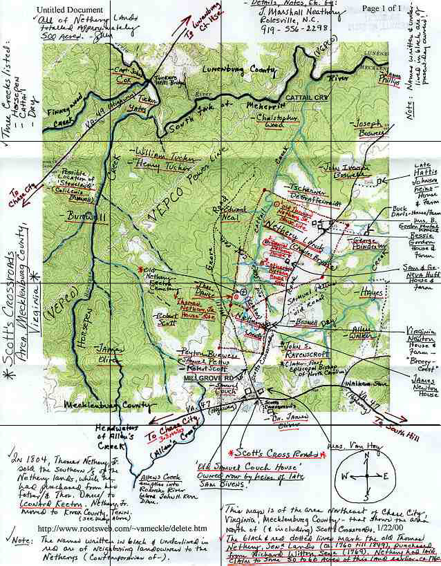
This is a portion of the USGS Gnis Chase City Quadrangle representing Cattail Creek, a branch of South Fork and the Scott's Crossroads area. The detailed notes are credited to J. Marshall Neathery of Rolesville, NC. 2 Feb 2000.

Allen's Creek
Sam Bivens
Boswell
John Iverson Boswell
Joseph Boswell
Cattail Creek
Chase City (historically "The City")
Cox's Cart Path
Breezy Crest
Charles Brydie
Burwell
Lewis Burwell, Col.
Peyton Burwell
Cattail Creek
Samuel Couch
Thos. Dance
Buck Davis
Tscharner DeGraffenreidt
Dry Creek
John Cox, Capt.
Finneywood Creek
Bessie Gordon
Hayes
Horsepen Creek
Geneva Huff
Sam Huff
Keeton
Leonard Keeton
Mill Grove Road
Edward Neal
Catherine Nethery
Daniel Nethery
Thomas Nethery, Jr.
Thomas Nethery, Sr.
Neathery-Keeton Cemetery
Virginia Newton
James Oliver, Dr.
Samuel Pettus
James Phillips
George Poindexter
John S. Ravenscroft
Robert Scott
Scott's Crossroads
South Fork of Meherrin River
South Hill
Stoneland
Tucker
Henry Tucker
William Tucker
VanHoy, Mrs.
Va Rt #49 (historically "City Road")
Allen Walker
Walker's Store
Richard Witton, Senr
Christopher Wood
Yates
Cattail Creek - Headwaters begin on the old Thomas Nethery Lands (now Breezy Crest Farm, owned by Mrs. Virgina Newton), one-half mile north of Va. Highway 47 and three miles northeast of the town of Chase City. This watercourse runs north through the old Nethery lands to the South Fork of the Meherrin River (at the Lunenburg County line). 1765 or earlier.
Cox's Cart Path - Beginning at Col. John Cox's place near South Fork of the Meherrin River, travelling southeastwardly across the lands of Edward Neal, Thomas Nethery, Sr., Samuel Pettus, and others, connecting with the road to Boydton. Note: Not to be confused with Cox's Old Road that began in Mecklenburg and travelled northeastwardly to Petersburg. 1775 earliest known.
Copyright © 1996 - The USGenWeb® Project, VAGenWeb, Mecklenburg County