

Mecklenburg County
VAGenWeb

11 Apr 1811; 15 Jul 1811; Leonard Claiborne & wife Mary M. Claiborne to John Bigger of Pr Edward 267acres; $297; on Finneywood Creek adj John Gregory; it being a part of the dower allotted to the sd Mary M. Claibourn of the land whereof her late husband David Stokes died seized. [Meck. DB14:428]
Mecklenburg Land Tax Records show Doct John Bigger was taxed with 385 1/2 acres adjoining John Gregory. In 1821, tax records show 334 acres was transferred to him from James Jones (possibly part of the Edward Jones, dec'd, estate). Subsequently, Doct Bigger was taxed with 719 1/2 acres.
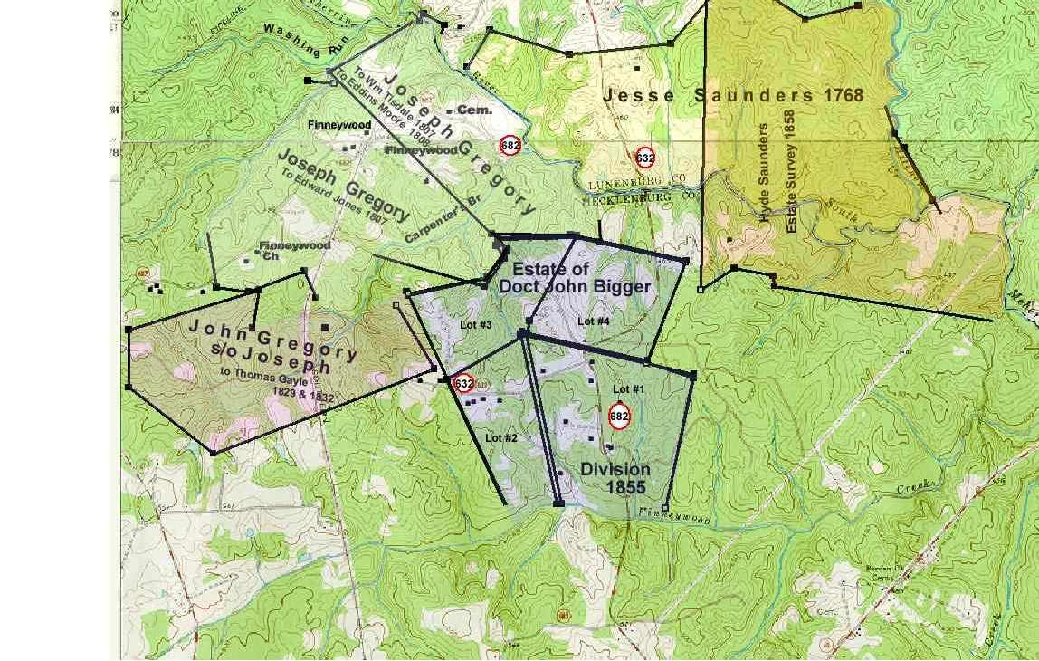
Lot No. 1 Widow's dower 250 acres to widow, Sarah M. Bigger. This lot shows the "dwelling house," adj. Mrs. Farrar's estate on the east. - Nov 1855
Lot No. 2 141 5/6 acres to Mrs. Newbill, adj. T. Gayle on the west.- Nov 1855
Lot No. 3 141 5/6 acres to Capt. Bigger, adj. T. Gayle on the west, David Thompson on the north. - Nov 1855
Lot No. 4 141 5/6 acres to Mrs. Boswell, adj. R. Saunders on the north, Capt. Bigger on the east. - Nov 1855
In an indenture dated 8 November 1855, Sarah M. Bigger surrendered
to heirs David J. Bigger, Elizabeth B. Boswell, John H. Newbill and
Mary Ann Newbill his wife, her interest in all that part of the land
of said John Bigger died possessed which was heired by said Sarah M.
Bigger from the Estate of David Stokes,father, also
all the right
title and interest which may have reverted to her from the death of
her mother Mary Claiborne formerly Stokes, in the land by her the
said Mary M. Stokes as her portion of her husband's estate which
lands now constitute a part of the land of which John Bigger died
possessed ...
This 400-acre tract was conveyed by patent in 1758, to Samuel Goode;
sold in 1759 to Branch Tanner and in 1779 to Matthew Marable. From
Marable's estate the tract went to daughter Elizabeth, who married
Philip Whitehead Jackson. Philip Jackson and wife sold it to her brother
Richard Marable in 1795, who in the same year sold it to John Gregory.
The only land measurements are in the original patent, and not
true enough for a good plot. Land records do show that his land adjoined
both his father, Joseph Gregory, and Capt. John Bigger.
All but
the first of the nine children of John and Elizabeth Gregory were born
between the date of purchase of this tract and the date land and tax
records show he had moved to his Lunenburg land.
In 1816, John
Gregory moved to land he had acquired on the Lunenburg side of the
river. He held on to the Mecklenburg tract until he sold to Thomas
Gayle, part in 1829, and the balance in 1832. Gregory family letters
show the part sold in 1829 belonged to John Gregory's son Jackson, who
had moved to North Carolina.
Meck DB 24:29; 5 Oct 1829; 20 Oct
1829
John Gregory and Elizabeth his wife of Lunenburg to Thomas
Gayle of Mecklenburg $424.50
283 acres on waters of South
Meherrin adjoining John Gregory, estate of Edward Jones dec'd, Lewis
Burwell and others. Likely, the portion of the estate bounding John
Gregory was land that Joseph Gregory conveyed to Edward Jones in 1807.
Meck DB 25:44; 20 Jan 1832;20 Feb 1832
John Gregory and Elizabeth
his wife of Lunenburg to Thomas Gayle of Mecklenburg $420.00
267
acres adjoining Thomas Gayle, John Bigger, and land belonging to estate
of Edward Jones.
On 12 Dec 1768 Susanna Fleming of
Cumberland County sold to Jesse Saunders of same county, 708 acres on the South
Fork of Meherrin River, at the mouth of Mitchell Creek, "it being part of a
tract of land which Colo John Fleming, late of the County of Cumberland,
attorney at law, purchased of Hugh Miller, and by him devised to the said
Susanna Fleming by his will, of record in Cumberland County." (rec. 18 Jun 1769
Lunenburg DB 11:269, from Jim Lewter) In 1780, Jesse Sanders [Saunders] was
granted 392 acres on branches of Meherrin, adjoining Burwell, Erskine and
Duprie.(GB E:536,537) The "three pines" landmark on the east of the tract at
Burwell's line was a landmark in the later John Gregory tract.
In 1786,
Jesse Saunders sold to Lewis Deupree, 190 acres of the above grant (leaving 202
acres). "From a white oak on small branch near Daniel Weatherfords spring to a
dividing line of marked trees run by agreement of the two parties to a pine in
Erskins line to Deupre's patent line." The bounders Erskine and Deupree suggest
to me the land conveyed was the western portion of the grant.
On 11 Aug
1790 (Lun. DB 16:179; ack. 13 Oct) Zachariah Davis of Lunenburg conveyed 290
acres adjoining said Sanders and bounded by his own lines, by Col Lewis Burwell,
Weatherford's, Brown's lines.
Jesse Saunders died in 1800. He owned land
in Cumberland and Buckingham Counties, as well as Lunenburg. His Lunenburg land
was willed to four of his five sons: Stephen, Robert, Hyde, and David Saunders
"all the land I now own in county of Lunenburg to be divided between them,
respect being had in the division to the quality as well as quantity of land
allotted to each." It appears from the Deed Index that Stephen sold to Hyde and
Robert in 1804. David's name doesn't appear on the Deed Index.
In April
1809, Hyde Saunders [Lun. DB 22:34] conveyed to Edward Jones of Mecklenburg, 176
acres in Lunenburg adjoining land of Robert Saunders, Richard Boyd [the adj.
Boyd tract should be the later 840-acre John Gregory tract/js] and Alexander
Erskine. (no measurements)
This may bear out to be the two 88-acre tracts
mentioned in the land descriptions of John Gregory: 88 acres conveyed by John
Goode to Thomas N. Gregory (became part of the Joseph F. Ellis farm) and 88
acres to John Gregory by Richard R. Jones. Edward Jones died in Mecklenburg
County about 1810; Richard R. Jones an administrator.
1824 Land Tax
Mecklenburg County Robert Saunders of Lunenburg 94 acres Meherrin adj Hyde
Saunders 9 NW Hyde Saunders of Lunenburg 276 acres Meherrin adj Robert Moore
estate 9NW
See Hyde Saunders' Land Tract at Lunenburg County VAGenWeb
Lunenburg DB 27:170; 3 Sep 1826 Hyde Saunders of Lunenburg to Robert Saunders of
Lunenburg, acres 452 & 279 Cons $1 ...for sundry good reasons...said Hyde
Saunders ... convey to his brother afsd Robert Saunders in trust all the
property both real and personal...for purpose of maintaining him during his
lifetime...one tract of land in county of Lunenburg on both sides Meherrin River
containing 452 acres bounded by lands of said Robert Saunders, John Gregory,
Thomas Couch, Alexr M. Hepburn and by the south branch of the Meherrin River.
Also one other tract lying in county of Mecklenburg on South side of Meherrin
River containing 279 acres by land of said Robert Saunders, William Coleman,
Boller Dobbyn and by the south branch of Meherrin River (also slaves etc.
Sig: Hyde Saunders, Robert Saunders. Witnessed by John H. Saunders, Emily C.
Saunders, Samuel G. Osborne, Elizabeth Osborne.
The 814 acres from Hyde
Saunders estate to Dr. William E. Dodson; then to Martha A. Swepson-Saunders,
wife of Dr. Samuel Saunders, son of Robert Saunders:
In 1850, the land of
Hyde Saunders in Lunenburg and Mecklenburg was surveyed to be 814 acres plus 160
poles, adjoining in Lunenburg: Robert Saunders on the west, John Gregory and
Mitchell's Creek on the north, and Hepburn on the east. In Mecklenburg, the land
adjoined Tucker and Oliver on the southeast, Oliver on the south, and Robert
Saunders again on the west. Land tax records for Hyde Saunders describe his land
as being 13 miles southwest of the courthouse, no stated value of tax for
buildings. Possibly Hyde lived on the adjoining grounds of| the old Saunders
home site. The 1850 census lists, one after the other in three households, the
families of Robert Saunders, Hyde Saunders and Robert Saunders, Jr.
Hyde
Saunders, unmarried, was deceased by 1858, when his tract of 814 acres was sold
to Wm. E. Dodson for $13,197, land bounded by Josephus Gregory, Wm. Couch,
Ebernezer ____? [maybe Hepburn], John G. Oliver and the estate of Robert
Saunders. (Rec. 11 Feb 1861, Lun. DB 27:24, files of James Lewter).
This
land transaction was mentioned in a letter written by Josephus Gregory to his
son Jackson, 8th Dec. 1858
"I informed you of the sale at Saunders. I
will however again give you some points at that sale. In the first place,
William Couch and myself bid as high as $16.20 per acre for the land. I was to
take 564 and he 250. He would have had the best [illegible] of the tract but was
willing to pay considerable more for his per acre than I was to pay. If we could
have bought it the 564 acres which I should have got would have made one of the
best situations in the county. If you could have been up at the time and wished
it and backed us in it we would have carried it to $20. But I did not know your
feelings about it. Couch says he regrets it more than any act of his life not
buying the place. Doctor Dodson is the owner. It will never be in market again
in our day, and if it was put up even now at highest bidder it would bring the
rise of $20 per acre. Lands are advancing every day." (Files of JoLee Gregory
Spears)
The 1860 Lunenburg Census shows the Dr. Dodson family listed next
to H. E. Hepburn, who may have been Dr. Dodson's father-in-law [UPDATE: Charity
A. Swepson was married to Alexander M. Hepburn (brother of H. E. Hepburn), and
it appears she was the same person remarried to Dr. Wm. E. Dodson before 1860.
See: Some Descendants of William Mallory Swepson.]
Incidentally, the
"Sweheston" name in the linked census transcription of the Hepburn household is
actually "Swepson." Possibly the Swepsons also were related to the Hepburn
family. A letter written by Josephus Gregory 2 July 1861 mentions the funeral of
Mrs. Dodson, adding: "I had not seen Mr. Hepburn for a length of time before
yesterday. He looks very feeble indeed. I should not be surprised if this heavy
affliction takes him off." It was mentioned that Mrs. Dodson left two little
children." By 1865, W. E. Dodson was styled "of Charlotte" in land tax records,
still no building or house valued. William Edward Dodson died in 1867 and is
buried in the Hepburn cemetery at Ravenscroft.
The Hyde Saunders tract
was conveyed to the wife of Dr. Samuel Saunders.
By deed recorded 3 June
1871, George W. Swepson bought the Dodson tract, the amount paid by R. R.
Swepson, substitute purchaser. Same date, R. R. Swepson gave the land to his
sister, Martha A. Saunders, with consent of Doctor Samuel Saunders. Samuel
Saunders, son of Robert, Sr., married Martha A. Swepson on Dec. 19, 1861. [Files
of James Lewter] In 1872, Martha A. Saunders was taxed with the 814 acres, and
for the first time, building(s) show a value, which was $200.
In 1875
Martha A. Saunders was taxed with 814 acres, 13 miles southwest of the
courthouse, $2000 added because of buildings. "R. R. Swepson '71 New buildings"
is written in the comment section.
No later records were obtained on this
tract of land, though I have seen a deed showing the Samuel Saunders tract (or
part of it) was conveyed to an Ellis. See portion of WPA map showing "Ellis
Farm." See division of the 814-acre tract and conveyance of 300+ acres of the
northern portion to George E. Ellis by the children of Dr. Samuel Saunders in
1902.
Robert Saunders and
Hyde Saunders were picked up on the 1827 Lunenburg land tax records. Robert was
taxed with 668 1/2 acres, house valued $350, described as South Meherrin River,
13 miles southwest of the courthouse. Hyde Saunders was taxed with 452 acres, no
building valued, described as Mitchell's Creek, 13 miles southwest of the
courthouse.
It appears that the land of Robert Saunders in Lunenburg
generally lay west of and adjoining the land of Hyde Saunders.
In
Mecklenburg, their land south of the river was taxed in 1824, 94 acres for
Robert Saunders adjoining Hyde Saunders, and 276 acres for Hyde Saunders
adjoining the Robert Moore estate.
Robert Saunders died 11 Dec. 1857. His
wife having preceded him in death 26 Mar. 1857 (Lun death records), Saunders
made a codicil to his will re his land. "It is my will and desire that my estate
be kept together until the next November or December after my death and my two
single daughters, Lucy A. Saunders and Anna E. Saunders or either one that
remains single, together with my son Saml. Saunders shall live at my house on
the estate, free of charge of any description until that time. At that time,
that is in November or December next after my death, I wish my executor to
deliver to each legatee, his or her specific legacy and sell the residue of my
estate and distribute it according to my will and or Mary C. Saunders, wife of
Robert Saunders, which(?) has provided means to purchase them a home. It is my
will and desire that my son Robert and family remove off the land they now live
on at the fall or by the first day of December next after my death, or pay full
rent for the same as long as he keeps possession and the possession shall be at
the option of my son Samuel and my two daughters Lucy A. Saunders and Anna E.
Saunders."
The sale to William T. Spencer and John A. Spencer.
By
deed dated 12 Jun. 1871, recorded 24 Jul. 1871, Samuel Saunders, executor,
conveyed the 880 acres to William T. Spencer and John A. Spencer, "(with the
exception of one half acres of said land the title to which is reserved to the
estate of said Roberts Saunders deceased because it contains the burying ground
of the white family of said Robert Saunders deceased)." The deed described two
parcels adjacent to each, the larger, 792 acres in the counties of Lunenburg and
Mecklenburg on the waters of Maherrin river and is bounded by the land of that
formerly belonged to the estate of Hyde Saunders deceased, C. Wood, Mrs. E. B.
Boswell, David J. Bigger, David Thompson, Mrs. Ann Lipscomb, Mrs. Mary Burnes,
then by the corner only of the smaller parcel of land belonging to the estate of
Robert Saunders deceased, then by Josephas Gregory to the beginning.
The
smaller parcel, 88 acres, in Lunenburg on the waters of the Meherrin bounded by
Mrs. Mary Burnes, A. A. Burwell, C. J. Thompson, J. F. Ellis, J. Gregory and the
larger parcel of land belonging to the estate.
In July 1871, John A. Spencer and William T. Spencer
partitioned the land in the following manner:
To Wm T. Spencer, 384
acres, the lands east of the new line, beginning at the gate on the road on the
south side of the river in Mecklenburg, then a straight line northward to the
center of the ford crossing the river at the old bridge, then northward along a
straight line to a sassafras stob westward of the old dwelling house, then
northward a short distance to a dogwood stob, then a straight line northward
across the lower end of a small field in...near the road leading to the farm
formerly owned by Hyde Saunders deceased, then to J. Gregory corner on Wm. T.
and John A. Spencer at a hickory sapling.
And all of that part, 44 acres,
commencing where J. Gregory, W. T. & J. A. Spencer and Mrs. burns corner on a
post oak on Saunders Road., then northwestward along the line of Mrs. Mary Burn
to a blank corner, to pointers on an old path running into the farm of said Mrs.
Burns. Then eastward a new line made as a dividing line to pointers on Saunder's
Road of the corner of J. F. Ellis fence, and then southward along sd road to the
beginning.
To John A. Spencer for his part:
All that part west of
the new line, 480 acres, and all that portion, 44 acres, of the smaller
beginning at pointers on the path near Mrs. Mary Burns farm, running northward
along the line of Mary Burns and A. A. Burwell, then along C. J. Thompson
eastward to corner post oak in Saunders Road., then along the road to where WM.
T. Spencer's corner by the new line on J. F. Ellis and then the new line
westward to the beginning.
The use of the turn or angle in the road
immediately on the south bank of the river is reserved for the use of said Wm.
T. Spencer and John A. Spencer, their heirs, etc. (Lun. DB 38:285, files of
James Lewter)
Contributed by JoLee Gregory Spears
Copyright © 1996 - The USGenWeb® Project, VAGenWeb, Mecklenburg County

This page was last updated
07/23/2026