

Mecklenburg County
VAGenWeb

! Abstracting info.
Typ
Id
Ref Meck Co., VA DB 48:331
Dat 6 Dec
1888
Rec 3 Jan 1889
Frm William W. Kitchen & Emile A. his wf of Rockford,
Winnabago Co., IL
To Frank L. Colby of Rockford
Con $6000
Re 156 54/100
acres in Mecklenburg (this is 2nd part)
Adj
Wit
!
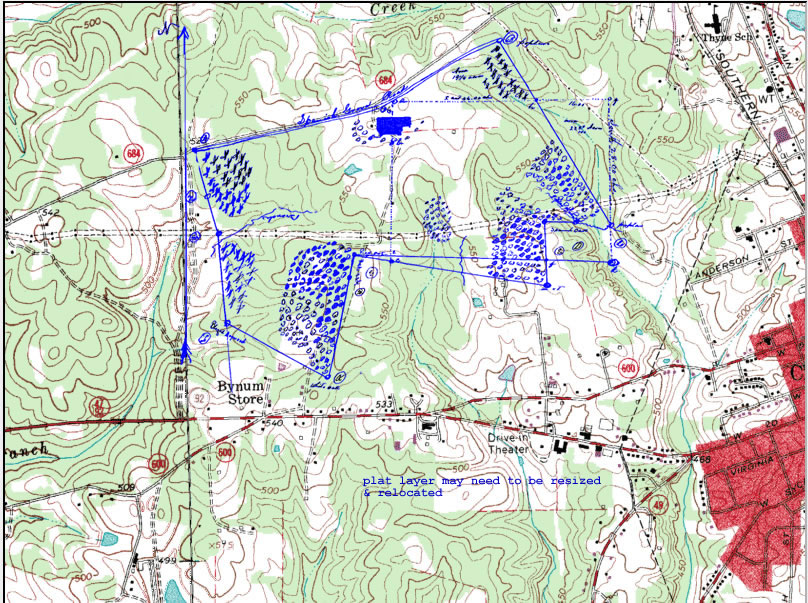
! Metes and
bounds. "Beginning at..."
pt 1) Also the following described tract of land
lying and being in said county and state and described as folllows: to wit:
Begining at cor rock on Spanish Grove Road in said County at "A" as designated
on sd Surveyor's plat, and running thence along sd road and the land of J. M.
Carpenter
ln N78.25E; 32p; 8chs;
pt 2)
ln N80.5E; 32p; 8chs;
pt 3)
ln N79E; 60p; 15chs;
pt 4)
ln N77.5E; 50.44p; 12 61/100chs; to
pt 5)cor
rock on said road at "a" as designated on sd plat, thence along the land of John
C. King through the house owned jointly by John C. King
ln S7.5W; 32p; 8chs;
pt 6)cor at "C"or b? as designated on sd plat, thence
ln S; 100.8p; 25
20/100chs; to
pt 7)"C" as designated on plat, thence along the land of Daniel
Fair
ln W; 30.4p; 7 60/100chs; to
pt 8)red oak cor designated on plat by
"G" thence
ln S13.5W; 14.4p; 3 60/100 chs; to
pt 9)a change in direction
at a fore and aft oak disignated on sd plat by "H", thence [bottom of page 331]
ln S21W; 66p; 16 1/2 chs to the land of
pt 10)Rosa B. Waddell at cor white
oak designated on plat by "K", thence along said land
ln N73.5W; 93.8p; 23
45/100chs; to a
pt 11)blazed dogwood desig on sd plat by "L" thence along the
land of A. F. Geiger
ln N3W; 80p; 20chs; thence
pt 12)
ln N9.5W; 28p;
7chs; thence
pt 13)
ln N17W; 42.4p; 10 60/100chs; to cor rock at place of
beginning at "A" as designated on plat
End
=======================
Typ
Id
Ref Meck Co., VA DB 48:331
Dat 6 Dec 1888
Rec 3 Jan 1889
Frm William W. Kitchen & Emile A. his wf of Rockford, Winnabago Co., IL
To
Frank L. Colby of Rockford
Con $6000
Re 164.71 acres in Mecklenburg (this
is one part)
Adj
Wit
!
! Metes and bounds. "Beginning ata cor rock
("a") on Plat made by W. J. Carter, then county Surveyor of said Mecklenburg
County, on Spanish Grove Road, in said County, and being the North East corner
of land of D. H. King in sd County, and thence along said road and along the
land of J. M. Carpenter..."
pt A)Beg at a cor rock ("a") on Plat on Spanish
Grove Rd and being the North East cor of land of D. H. King thence alg sd rd and
alg land of J. M. Carpenter
ln N77.5E; 1.56p; 39/100 chs;
pt B)
ln
N57.5E; 68p; 17chs;
pt C)
ln N57E; 46.4p; 11.60chs;
pt D)cor where six
poplars growing from one stump; then by land of Lewis Williams
ln S25E;
214.68p; 53.67chs;
pt E)cor at "K" as marked on plat, then by land of Daniel
Fair due w
ln W; 184.32p; 46.08chs;
pt F)"C" as marked on plat, thence due
North alg land of D. H. King
ln N; 100.8; 25.20chs; to cor at "b" or "c"
pt G)"b"? as marked on plat then through the house owned jointly by John C. King
and D. H King
ln N7.5E; 32p; 8chs;to beg
End
Contributed by JoLee Gregory Spears
Copyright © 1996 - The USGenWeb® Project, VAGenWeb, Mecklenburg County

This page was last updated
07/23/2026