

Mecklenburg County
VAGenWeb

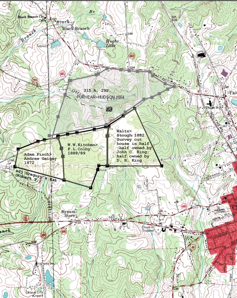
Ref Meck DB37:52
Dat 3 Feb 1864
Frm A. G. Jeffress & R. R. Puryear exor of
R. C? Puryear of Meck
To Richd N. Hudson? of Powhatan
Con 11,031 34/100
dollars
Re 315 acres & 29 poles
Adj Adam Finch, Dr. Jno J. Boswell, Col
Lyddall Bacon & Thos F. Goode in the fork of three roads and on both sides of a
branch called Otter Creek Branch and bounded as follows
Wit
!
! Metes
and bounds. "Beginning at..."
Pt 1) Beginning at Hals pond at the fork of the
road leading to Spanish Grove and Jackson Toon's? new road at A thence following
said Toon's Road
Ln N14E; 20p;
Pt 2)
Ln N17E; 24p;
Pt 3)
Ln N16E;
88p;
Pt 4)
Ln N18E; 78p;
Pt 5)
Ln N17E; 50.92p;
Pt 6) Dr. R. N.
Hudson's corner at B. (no corner tree standing) thence leaving the road
Ln
N88E; 4p; try eastLn N88; 4p; thence
Pt 7)
Ln N77.5E; 88p;
Pt 8)
Ln
N71E; 8p;
Pt 9)
Ln N57E; 34.72p;
Pt 10) to the Keysville Road at C
thence following said road
Ln S85E; 48p;
Pt 11)
Ln S82.5E; 28p;
Pt
12)
Ln S85E; 28p;
Pt 13)
Ln S88E; 42.16p;
Pt 14)
Ln S35E; 16p;
Pt 15)
Ln S57.5E; 50p;
Pt 16)
Ln S72.5E; 32.36p; to
Pt 17) fork of
the road at D thence on Spanish Grove road
Ln S68W; 24p;
Pt 18)
Ln
S61.5W; 32p; thence
Pt 19)
Ln S64W; 28p; thence
Pt 20)
Ln S77W; 28p;
(line through numbers)
Pt 21)
Ln S55W; 76p;
Pt 22)
Ln S56.8W;
77.24p;
Pt 23)
Ln S79W; 196.86p; to beginning
End
Ref DB 39:118,119 Mecklenburg Co., VA
Dat 21 Sep 1872;
Rec 21 Sep 1872
Frm
Adam Finch & Martha W. his wife
To Andrew F. Geiger
Con $1,015.25
Re
101 5/8 acres
Adj Spanish Grove road, Gregorys Estate
Pt 1) Beg at a __?__
Persimmon treeon south side of the Spanish Grove road at the corner of other
lands of said Finch, then along said road
Ln S80W; 46p;
Pt 2)
Ln S76W;
22p;
Pt 3)
ln S69W; 72p;
Pt 4) cor hickory on the line of the land of
Gregorys Estate, then along line of lands of Gregorys Estate
Ln S10.5W;
60.5p;
Pt 5) cor at a pile of rocks near a large hickory tree, then by the
line of lands of sd Gregory's Estate
Ln S75E; 172p;
Pt 6) Blazed dogwood
at cross fence,thence by other lands of said Finch
Ln N3W; 79.25p;
Pt 7)
Ln N11W; 27p;
Pt 8)
Ln N16.5W; 40p; to place of beginning
End
Ref Meck Co., VA DB 48:331
Dat 6 Dec 1888
Rec 3 Jan 1889
Frm
William W. Kitchen & Emile A. his wf of Rockford, Winnabago Co., IL
To Frank
L. Colby of Rockford
Con $6000
Re 156 54/100 acres in Mecklenburg (this is
2nd part)
Adj Spanish Grove Road, J. M. Carpenter, John C. King, Daniel
Fair,Rosa B. Waddell, A. F. Geiger
pt 1) Also the following described
tract of land lying and being in said county and state and described as
folllows: to wit: Begining at cor rock on Spanish Grove Road in said County at
"A" as designated on sd Surveyor's plat, and running thence along sd road and
the land of J. M. Carpenter
ln N78.25E; 32p; 8chs;
pt 2)
ln N80.5E;
32p; 8chs;
pt 3)
ln N79E; 60p; 15chs;
pt 4)
ln N77.5E; 50.44p; 12
61/100chs; to
pt 5)cor rock on said road at "a" as designated on sd plat,
thence along the land of John C. King through the house owned jointly by John C.
King
ln S7.5W; 32p; 8chs;
pt 6)cor at "C"or b? as designated on sd plat,
thence
ln S; 100.8p; 25 20/100chs; to
pt 7)"C" as designated on plat,
thence along the land of Daniel Fair
ln W; 30.4p; 7 60/100chs; to
pt 8)red
oak cor designated on plat by "G" thence
ln S13.5W; 14.4p; 3 60/100 chs; to
pt 9)a change in direction at a fore and aft oak disignated on sd plat by "H",
thence [bottom of page 331]
ln S21W; 66p; 16 1/2 chs to the land of
pt
10)Rosa B. Waddell at cor white oak designated on plat by "K", thence along said
land
ln N73.5W; 93.8p; 23 45/100chs; to a
pt 11)blazed dogwood desig on sd
plat by "L" thence along the land of A. F. Geiger
ln N3W; 80p; 20chs; thence
pt 12)
ln N9.5W; 28p; 7chs; thence
pt 13)
ln N17W; 42.4p; 10 60/100chs;
to cor rock at place of beginning at "A" as designated on plat
End
Ref Meck Co., VA DB 44:314
Dat 2 day of Jan 1882
Frm T. J. Waltz &
Wlla E. Waltz his wf of Dixon Co, Neb
To John Stough
Re 523 ? acres
! Metes and bounds. "Beginning at.Beg at cor rock on platt made by J. W.
Carter (then county surveyor) on Spanish Grove Road being the N.E. cor of the
land of D. H. King and thence alg said road and along the land of J. M.
Carpenter.."
pt 1)Beg at cor rock on Spanish Grove Rd being the N.E. cor D.
H. King thence alg sd road and along land of J. M. Carpenter
ln N77.5E;
1.56p; 39/100 chains
pt 2)
ln N57.5E; 68p; 17 chains
pt 3)
ln N57E;
46.4p; 11 60/100 chains to
pt 4) cor 6 poplars growing from one stump, then
by the land of Lewis Williams
ln S25E; 214.68p; 53 67/100 chains to
pt 5)
cor at (K) thence
ln W; 184.32p; 46 8/100 chains by land of Daniel Fair to
(B) or (C) thence
pt 6)
ln N; 100.8p; 25 20/100 chains by land of D. H.
King to
pt 7) cor at (g) or (b) thence
ln N7.5E; 32p; 8 chains through the
house owned jointly by John C. King and D. H. King to beginning
End
Contributed by Jo Lee Spears
Copyright © 1996 - The USGenWeb® Project, VAGenWeb, Mecklenburg County

This page was last updated
07/23/2026