
Sullivan County
NHGenWeb

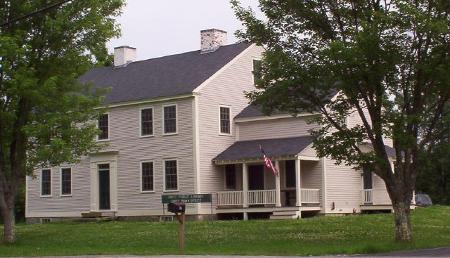 The Tavern sits at the northern end of lot
75 in the second range of 100 acre lots (as originally granted by the
proprietors of Unity in the 1760’s), looking out across the Town Common towards
the site of the original town house (moved here from another location in town in
1829) and towards the old Baptist church (since 1877 the Town Hall). It is at
the center of the town and faces the second rangeway, the principal east-west
thoroughfare of the town, 100 yards from its intersection with the Second New
Hampshire Turnpike.
The Tavern sits at the northern end of lot
75 in the second range of 100 acre lots (as originally granted by the
proprietors of Unity in the 1760’s), looking out across the Town Common towards
the site of the original town house (moved here from another location in town in
1829) and towards the old Baptist church (since 1877 the Town Hall). It is at
the center of the town and faces the second rangeway, the principal east-west
thoroughfare of the town, 100 yards from its intersection with the Second New
Hampshire Turnpike.
The turnpike, chartered in 1799, was the principal
focus of the town’s economic activity for the first half of the nineteenth
century. During this period, until the Sullivan Railroad reached Claremont in
1849, it carried a large part of the traffic from this part of New Hampshire and
from Vermont, headed towards Hillsborough, Nashua, and eventually Boston. Branch
turnpikes, from Lebanon, Cornish, and Charlestown, which joined the Second New
Hampshire Turnpike in Lempster, bypassing Unity, and the Third, and Fourth
turnpikes (from Walpole, Charlestown, and Lebanon, respectively) also provided
alternative routes in the direction of Boston.
But there was enough
traffic through Unity to support a number of stores and other commercial
establishments, as well as Chase’s Tavern. This turnpike era, coincided with the
decades of prosperity resulting from the boom in sheep farming, saw Unity reach
a population of about 1300 between 1820 and 1840. Without any significant water
power, Unity was unable to participate fully in the industrial economy of the
late nineteenth century. Its economy declined, and with it the population,
reaching a low of 501 in 1930.
The present tavern building appears not to
have been built until about 1800, the “dwelling house of Abner Chase” figures
prominently in town records from the second town meeting in 1774 onwards. Almost
every town meeting until about 1801, when a proper meeting house appears to have
been built, was held at his house or in his barn. The house referred to in the
early years may have been at or near the present tavern or perhaps across the
road on one of the other lots that Abner owned. Proprietors’ meetings began to
be held in Unity in 1792 and were also almost always held at Abner’s house.
He was first issued a tavern license in 1791 and these were reissued
annually until 1797. In 1798 his son Francis received a license and licenses
were reissued regularly to one or the other of them until at least 1837. The
tavern was clearly more than just a social center for the village and town.
Francis Chase (almost always referred to as “Esquire”) was postmaster for many
years, in the 1820’s and 1830’s and as late as 1850, the year he died. He was
selectman from about 1801 to 1809 and town clerk in 1800 and again in the late
1840’s. He was a director of the Unity Scientific and Military Academy from 1836
to 1842 and always listed first in the roster of officers, even though out of
alphabetical order. In 1837 thirty-one Academy students are listed as rooming at
his residence.
The militia muster field was located behind the tavern,
down the road to Acworth, either on the 35 acre lot on which the Tavern sat or
on the 85 acre south section of lot 75 sold to Daniel Huntoon in 1835. The
tavern must have been a very busy place, especially when the Academy was in
session or on muster days.
The Chase’s were definitely engaged in the
tavern business for many years, the building was built as a tavern, and land
ownership records tie the Chases to this lot of land from 1780 to 1848. In an
1844 deed it is said to be “known by the name of the Chase Tavern Stand” In 1838
it is described as “about 50 acres of land…with a dwelling house, barns,
sawmill, etc.
The upper reaches of the Little Sugar River flow through
the 35-acre lot and at the northwest corner there was a sawmill. In the 1840’s
Francis Chase first leased and then sold the one acre tract at the mill site.
The remains of the mill are still visible, but they are not on the present
Tavern lot.
From this time forward the property no longer maintained its
importance as a focus of community life. It was simply a large single-family
dwelling and by the late 1920’s or early 1930’s had even been divided into
separate apartments.
It went through a fairly rapid succession of owners,
none of them apparently affluent enough to make any significant changes. Charles
and Marjorie Coe, who owned the property from 1960 to1964, took a real interest
in the historic features of the property. James Fusscas, owner from 1969 to
2001, made some fairly major changes and also undertook major repairs.
Unfortunately, the property sat vacant and unheated during most of the 32-year
period and suffered some serious damage, especially in the basement.
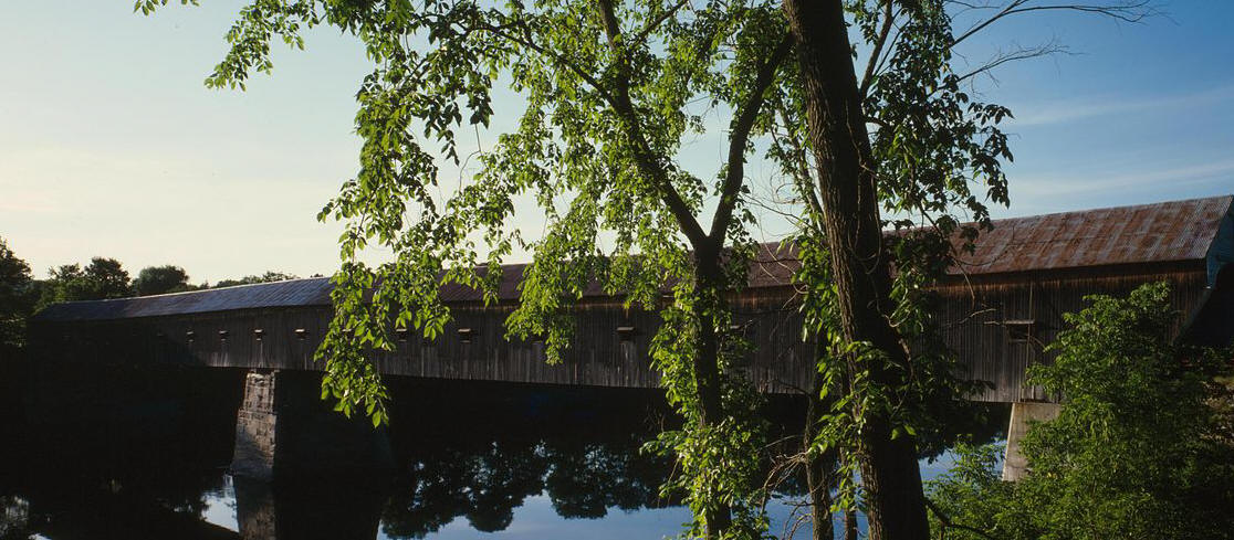
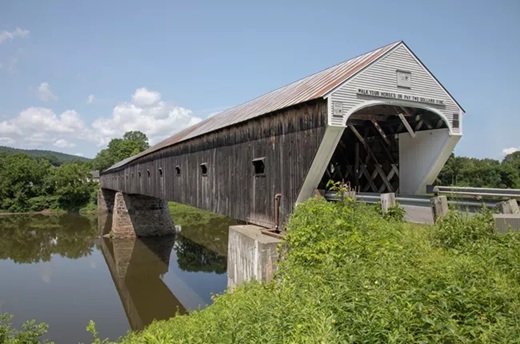 Officially, there is only one Bridge Listed in Sullivan County.
It goes from Cornish to Windsor, VT. It is the longest
covered bridge in the United States.
Officially, there is only one Bridge Listed in Sullivan County.
It goes from Cornish to Windsor, VT. It is the longest
covered bridge in the United States.
The 2-span, 449'-5" (1866)
Connecticut R., W. of NH 12A, 5 mi S of Plainfield Village. Town lattice truss.
This is the 4th bridge on this site. It was built in 1796 (probably uncovered)
and destroyed by floods in 1824, 1848, and 1866. The present was built in 1866
by James Tasker and Bela Fletcher. Designated a National Historic Civil
Engineering Landmark in 1970 by the American Society of Civil Engineers.
Sugar Reach: North Newport to Rt 103 County: Sullivan Claremont. Passes
under three covered bridges. Few houses visible from the river. Halfway point at
bridge in Kellyville. Description provided by Allan Berggren,11 South St.,
Claremont, NH. 03743, 603-542-7707
In The Dartmouth - Lake Sunapee
Region:
Andover - Cilleyville: 53 ft (1887) Pleasant Stream, NH 11, at
Jct, with NH 4A. Town lattice truss. Foot traffic only, bypassed by highway in
1959.
Andover - Keniston: 64'-6" (1882) Blackwater R., S of US 4, 1 mi
W. of Andover Village. Town lattice truss, granite abutments built by Albert R.
Hamilton. Cost $745.57.
Bradford-Bement: 60'-6" (1854) at West Branch,of
Warner R., S. of intersection NH 103 and 114. Long truss, newest of the four
bridges spanning the Warner River. Repaired in 1070 for $20,000. Original cost
$500.
Cornish-Blacksmith: 91 ft. (1881) Millbrook, Cornish City, 3 mi E
of NH 12A. Multiple Kingpost truss, built in the Town Hall Yard by James Tasker,
a rural construction genius who could neither read nor write.
Cornish-Blow-Me-Down: 85'-9" (1877) Blow-Me-Down Brook, S of NH 12A, 1 1/2 mi SW
of Plainfield Village. Multiple Kingpost truss, built by James Tasker.
Cornish-Dingleton: 77'-9" (1882) Millbrook, Cornish Mills. 1 mi E of NH 12A.
Multiple Kingpost truss. Built in schoolhouse yard by James Tasker.
Langdon-Cold River: 81 ft. (1869) Cold R., N of NH 123A, 2 mi N of Alstead
Village. Town lattice truss, auxillary arch, built by Albert Granger. Foot
traffic only. Bypassed by highway in 1964.
Langdon-Drewsville: 34'-6"
(1874), Great Brook, 1 mi. S of NH 12A at Langdon Village. Town lattice truss,
shortest highway covered bridge in NH. Foot traffic only, bypassed by highway in
1955.
Lyme-Edgell: 132 ft. (1885) Clay Brook, 1 mi S of NH 10-2 mi S of
Orford Village. Town lattice truss, built by Walter and J.C. Piper. The trusses
were constructed on Lyme Common and transported to the bridge site-"a
forerunning of modern prefabrication".
Lebanon-Packard Hill: 76 ft,
(1991) Mascoma River, Riverside Dr, Lebanon. Howe Truss built by Graton Assoc.
Designed to H-20 loading, inside width 15 ft and height 12 ft. 5 ft sidewalk on
upstream side. Replaces Bailey Bridge which was erected in 1952. To replace
earlier covered bridge built in 1878.
Newport-Corbin: 96'-2" (around
1845) Croyden Branch, Sugar R., 1/2 mi W of NH 10. 2 mi N of Newport Village.
Town lattice truss. Destroyed by arson May 27, 1993. Rebuilt in 1994.
Newport-Pier or Chandler Station: 2-span, 216'-7" (rebuilt 1896)
Sugar R., E
of Chandler Station. Double Town lattice truss, originally built 1871-72.
Newport-Wright's: 122 ft. (rebuilt 1895) Sugar R., W of Chandler
Station.
Double Town lattice truss, added laminated arch.
Plainfield-Meriden: 80
ft. (1880) Blood's Brook, 1 mi NW of NH 120 at Meriden. Multiple Kingpost truss,
built by James Tasker for $300. Restored to 15-ton capacity using steel
stringers in 1963. New roof erected in 1977.
Warner-Dalton: 76'-6" (about
1853) Warner R., S. of NH 103 at Warner Village. Multiple Kingpost truss,
auxiliary Queenpost truss. Rebuilt in 1963.
Warner-Waterloo: 76'-4"
(1840s) Warner R., S. of NH 103, 2 mi W. of Warner Village. Town lattice truss.
Rebuilt 1972 for $16,000.
MERRIMACK VALLEY REGION
Merrimack-Baboosic Brook: 32.5 ft (1990) Baboosic Brook, on Stowell Rd in
Merrimack. Prefabricated Panel-lam floor system, not traditional style.
Henniker-New England College: Single span. 136'-7", Contoocook R. Town lattice
design. Built 1972 by Milton S. and Arnold Graton at a cost of $80,000. South of
Rt 9 in the village.
Hopkinton-Railroad Bridge: 2-span, 157 ft. (rebuilt
1889) Contoocook R., E. of NH 103 at Contoocook. Double Town lattice truss.
Originally built in 1849-50 when Concord and Claremont railroad constructed its
first 33 miles of road from Concord to Bradford. Washed off its abutments in
flood of 1936 and hurricane of 1938. Drawn back and restored. Owned by N.H. Dept
of Cultural Affairs.
Hopkinton-Rowell's: 164'-6" (1853) Contoocook R., N.
of NH 127 at W. Hopkinton. Built by Horace Childs, this was originally a 1-span
modification of the Burr and Long truss bridges with arches whose solid timbers
are fitted end to end and mortised into a double panel frame as an integral part
of the trusses. Completely rebuilt in 1965.
 Acworth is a
picturesque hilltop community, boasting a church dating back to 1821 featuring a
magnificent bell tower, which houses an 1828 Revere-firm bell, graceful
Palladian windows and other Federal elements.
Acworth is a
picturesque hilltop community, boasting a church dating back to 1821 featuring a
magnificent bell tower, which houses an 1828 Revere-firm bell, graceful
Palladian windows and other Federal elements.
The town of Acworth sits in the west central part of New Hampshire. To the west, lies the Connecticut River which begins at the Connecticut Lakes on the Canadian border and flows south all the way to Long Island Sound. Acworth is a picturesque New England town in the mountainous section of the state. The town is divided into Acworth Center (top of the mountain) and South Acworth (in the valley along Cold River).
Helen H. Frink's book, These Acworth Hills, tells the history of the community from 1776 to 1988. Frink's book is a wealth of information on the growth and history of this small New England community.
No one knows who found the Beehives first. It just seemed that were a conversation piece in the community. At first, many thought they were built by one of the Native American tribes in the area. Today we know this is not true. As time went by, they became less of a subject.
In 1947, William Goodwin published a book entitled, The Ruins of Great Ireland in New England, Mr. Goodwin's book was based on what he found on his property in Salem, New Hampshire which he called "Mystery Hill", or as some have come to call it, "America's Stonehenge".
In 1947, Dr. James Whittall visited Kennedy Hill ( the Acworth site) and found the very similar to the stone structures built by the Celts in northern Spain and Portugal. This goes along with William Goodwin's theory that Mystery Hill, Acworth and similar sites in northwestern Massachusetts and eastern Vermont were built and inhabited by Irish Culdee monks fleeing Norsemen or Vikings. Goodwin theorized that monks tried to Christianize the Algonquian natives living in New England in the ninth and tenth centuries.
Berry Fell, a Harvard marine biologist, who had studied pre-Christian hieroglyphics and inscriptions at several North American sites pursued Goodwin's Celtic-Irish hypothesis back into history. In Fell's book, America B. C., he concluded that Phoenicians traded extensively with Celts from the Iberian Peninsula. The Celts traded furs and copper, which could have come from North America. In Fell's examination of inscriptions on stones at Mystery Hill, he found one dedicated to the Phoenician god Baal and another to the Celt sun god Bel which were the same deity.
The script was pre-Christian Celt called Ogam. This script was found at other similar sites in the northeastern United States. When fell examined the Algonquian language he found evidence of Gaelic origins for place names such as Amoskeag, Piscataqua and Queechee. Based on these findings, Fell concluded that the Celts and Phoenicians had visited and traded in New England between the tenth century before Christ and 146 B.C.
Fell and Whittall concluded that Mystery Hill was a religious shrine created by the Celts and used by the Phoenicians who came here to trade. The site's link to human or animal sacrifice has been well researched. Stone huts like the ones at Mystery Hill and Acworth faced eastward so the Bel's worshippers could see the sunrise from them on the winter solace. Whittall did not explore the possibility that the Acworth Beehives had any astronomical connections. Another Visitor to the Beehives theorized that lines drawn from each of the three remaining Beehives would intersect near the top of the hill where their is a large, flat table rock that could have been an alter.
In his book, Albins, Farley Mowat talks about pre-Viking settlers in the Northern Labrador/Ungava (mouth of the St. Lawrence River region. The remains of a stone dwelling was discovered that predates the 8th century Viking presence and is not of Inuit or Native American origin.
There is evidence of old maps that were noted as being in the possession of the Vikings that identifies the Nova Scotia and Gaspe region of the St. Lawrence as the Huitramannaland (land of the white man). There is also the old Iroquois tale about " men in white robes". Is it possible that these settlers were Celtic Christians or even Culdees fulfilling the command of Jesus, to" go and preach the Gospel to the utter most parts of the earth".
The theory is that the Beehives were built between 800 B.C. and they were temples rather than Dwellings. Now it's my turn to tell what a friend and I found at the Beehives. We walked up one fall day and started looking around the site. We started with the largest hut. Looking around we noticed that just below the hut were ledges with a small stone wall built in a semicircle. While I was looking at the wall my friend crawled into the large hut and started to look around.
After a few minutes, she called out that she had found something. I went up and she told me to look in the wall on the right side of the entrance to the hut. When I found the spot she was referring to, I found wedged in the stone wall mixed in with dirt and leaves a small dull stone. Taking it out and cleaning it off we found it to be some sort of crystal. Going back inside and replacing the crystal where I had taken it from. Looking around I noticed two triangular openings on the opposite wall facing the east. These openings were about two and a half feet up in the wall and about a foot apart one was slightly higher than the other. going outside and shining a flashlight through both the openings, we found that shining the light at the right angle the light would hit the crystal and the reflect on to the base stone of the far wall.
Shining the flashlight on the base stone revealed that it was about a foot high and four feet long. Closer examination of the stone revealed that it had a flat surface covered in moss. Pressing my hand into the moss I felt certain irregularities in the stone. Not having anything to remove the moss we decided to leave it on the stone.
We next went to the top of the site where a large flat stone was in place. Taking a small steel rod and poking around the flat stone we found other stones under the large one that when struck with the steel rod gave off a hollow sound. Taking a cigarette and holding the lit end near one of the jointed stones we found a slight breeze coming out of the joint blowing the smoke away indicating there may be a opening underground. Since the stones were too large for us to lift, we moved to the back side of the site. One thing that had bothered me on what I had read about the site was there was no sign of human habitation. On the backside of the site we found there were other stones stacked in an irregular fashion. If one followed the direction of the long line of stones, one would come to Mitchell Pond. If this site was a temple or gathering place then it would seem that anyone in the area would live in a sheltered valley close to water.
Could it have happened this way that people from Europe did come into the New World by way of the St. Lawrence River and then overland to the Connecticut River and then going overland through this area and down onto the Mystery Hill site?
Written by William Raymond. He was Chief of Police of Acworth from 1991 to 1997. He moved to Alaska where he worked for the State as a supervisor for the new juvenile detention facility.
The town was first chartered under the name Burnet in 1752 after William
Burnet, colonial Governor of Massachusetts and New Hampshire in 1728. However,
no settlements occurred under the original charter, so the town was re-granted
in 1766 with the name Acworth, in honor of Sir Jacob Acworth, a British Admiral
who had Portsmouth shipping interests.
From the New Hampshire Gazetteer
published in 1817, ACWORTH - a post-township of Cheshire county, bounded on the
N. by Unity, E. by Lempster, S. by Alstead and Marlow, W. by Charleston and
Langdon, containing 24,846 acres. It was incorporated in 1776, and has 1523
inhabitants. Cold-pond, extending about a mile on the line of Unity, from 60 to
100 rods in width, and Mitchell’s pond, 120 rods long and 80 wide, are its only
ponds of note.
Cold river takes its rise and name from one of the above
mentioned pools in the N.E. corner of this town. Acworth has two religious
societies; 1 meeting-house for the congregational order, 1 grain mill, 5
saw-mills, 2 mills for dressing cloth, 2 carding machines, and 1 trading store.
Rev. Thomas Archibald was settled in the ministry here in 1789. Rev. Phinehas
Cook is the present minister of the gospel. The Charleston turnpike road passes
through here. Acworth is 73 miles N.W. by W. from Portsmouth.
Plantation No. 4, which eventually became Charlestown, was originally
chartered by Massachusetts in 1735. No. 4 was the farthest north, and the most
exposed, in a chain of four settlements which were created primarily to protect
the western Massachusetts towns that were often the target of Indian attacks.
When the French and Indian Wars took place, the settlers in this vulnerable
outpost pulled several houses together, built a palisade to protect them, and
created the Fort at No. 4, a fortified village, not a military fort. Life at the
fort was dangerous and hard until King Philip’s War finally ended.
Since
the area settled was actually in New Hampshire, the town was chartered by New
Hampshire in 1753, and named Charlestown. At one time, so many noted lawyers and
judges resided in the town that it was known as the most important law center
north of Boston. The rude frontier outpost became a cultured village of gracious
homes. During the 1800s, the town was a destination for summer visitors who
stayed in the many large hotels.
Today, Charlestown is located in what is
called the "Quiet Corner" of New Hampshire, surrounded by hills, beside the
Connecticut River. It is still a small town with about 5,000 people. It is a
fine place to live or visit, and the town has preserved many of its wonderful
historic features. Proud of its history, the town has retained many records of
its earlier days, and has many resources for those seeking information about
their forebears.
It was named after Claremont, the country mansion of Thomas Pelham-Holles,
Earl of Clare. On October 26, 1764, Colonial Governor Benning Wentworth granted
the township to Josiah Willard, Samuel Ashley and 67 others. Although first
settled in 1762 by Moses Spafford and David Lynde, many of the proprietors
arrived in 1767, with a large number from Farmington, Hebron and Colchester,
Connecticut. The undulating surface of rich, gravelly loam made agriculture an
early occupation.
It was water power from the Sugar River, however, which
brought the town prosperity during the Industrial Revolution. Large brick
factories were built along the stream, including the Sunapee Mills, Monadnock
Mills, Claremont Machine Works, Home Mills, Sanford & Rossiter, and Claremont
Manufacturing Company. Principal products were cotton and woolen textiles,
lathes and planers, as well as paper. Although like other New England mill
towns, much industry moved away or closed in the 20th-century, the city's former
prosperity is evident in some fine Victorian architecture, including the 1897
city hall and opera house.
 Established in 1763, the town was once known as Mast Camp, because it was the
shipping point for the tall masts floated down the river by English settlers.
Incorporated in 1765 by Colonial Governor Benning Wentworth, it was named for
Sir Samuel Cornish, a distinguished admiral of the Royal Navy. Cornish has
historically been and continues to be a well-known summer resort for artists and
writers. Seeking a studio away from the summer heat of New York City, sculptor
Augustus Saint-Gaudens began coming to Cornish in 1885. Artist friends followed
him, including painter and illustrator Maxfield Parrish, who designed and built
his estate, the Oaks, in the area. The surrounding area became the center of the
popular Cornish Art Colony. Cornish is the site of the longest wooden
covered bridge in the United States, and the longest two-span covered bridge in
the world. The Cornish-Windsor Covered Bridge, which spans the Connecticut
River, was built in 1866 at an original cost of $9,000. Cornish also
gained notable attention on January 27, 2010, when American author J. D.
Salinger died in the local hospital. He was 91 years old.
Established in 1763, the town was once known as Mast Camp, because it was the
shipping point for the tall masts floated down the river by English settlers.
Incorporated in 1765 by Colonial Governor Benning Wentworth, it was named for
Sir Samuel Cornish, a distinguished admiral of the Royal Navy. Cornish has
historically been and continues to be a well-known summer resort for artists and
writers. Seeking a studio away from the summer heat of New York City, sculptor
Augustus Saint-Gaudens began coming to Cornish in 1885. Artist friends followed
him, including painter and illustrator Maxfield Parrish, who designed and built
his estate, the Oaks, in the area. The surrounding area became the center of the
popular Cornish Art Colony. Cornish is the site of the longest wooden
covered bridge in the United States, and the longest two-span covered bridge in
the world. The Cornish-Windsor Covered Bridge, which spans the Connecticut
River, was built in 1866 at an original cost of $9,000. Cornish also
gained notable attention on January 27, 2010, when American author J. D.
Salinger died in the local hospital. He was 91 years old.
Incorporated in 1761, Grantham took its name from Thomas Robinson, 1st Baron Grantham, Secretary of State for the Southern Department from March 1754 to October 1755. The families of Howe, Dunbar and Leavitt were all early Grantham settlers. All three families secured lands in Grantham as part of the charter granted to Baron Grantham in 1761, and all three families "have Grantham hills named after them," according to Elmer M. Hunt in New Hampshire Town Names and Whence They Came. "The Leavitts are said to have had at one time fifty children in attendance at the town's school, and over the years no fewer than seventeen teachers."
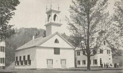
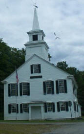 The town hall building was completed in 1803. This church
and town hall has been known as the old meeting-house, the east meeting-house,
the town hall and the Universalist church. It required many years to select a
"spot" for its erection and final completion. The subject of erecting a meeting
house, drawing plans and marking a spot for its erection were considered in town
meeting, April 14, 1791, Sept 10, 1792 and March 5, 1793 but not much was
accomplished.
The town hall building was completed in 1803. This church
and town hall has been known as the old meeting-house, the east meeting-house,
the town hall and the Universalist church. It required many years to select a
"spot" for its erection and final completion. The subject of erecting a meeting
house, drawing plans and marking a spot for its erection were considered in town
meeting, April 14, 1791, Sept 10, 1792 and March 5, 1793 but not much was
accomplished.
Subsequently a petition to the State of NH for a special
tax to build a meeting house was made. So far as discovered, no action was taken
on the petition.
At a meeting on March 4, 1800 the town chose, Capt.
Benjamin PALMER, Levi HOLDEN, Samuel PROUTY, Asa WALKER, John FRENCH, Joseph
WILLARD and Jeremiah HOWARD a "Committee to find a Spot to Set a meeting House"
and they reported April 1st that "the Best Spot for a meeting house near the
Center of the town is on a knoll Between Capt. [Elijah] Putnam's North Line and
the Road where Stands a tall White Birch Stub from 20 to 30 rods west from Capt.
Putnam's house". From Kingsbury's History of Langdon.
The building was
designed after the Rockingham, Vermont meeting house and the master builder was
probably John CHANDLER of Alstead. It is also the Universalist Church, but has
not held church services there for many years, however, annual Old Home Day
church services have been held there in recent decades. The town offices are
located on the ground floor.
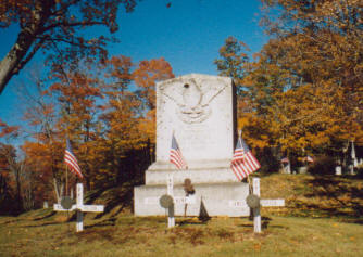 The Langdon Soldiers World War Two monument, at the entrance to the Village or "upper
cemetery" next to the Town Hall, honors the Langdon boys, who lost their lives:
The Langdon Soldiers World War Two monument, at the entrance to the Village or "upper
cemetery" next to the Town Hall, honors the Langdon boys, who lost their lives:
James Benton Porter
Maurice Pelton
Leslie Kemp
There are two covered bridges in or near Langdon: McDermott Bridge and Prentiss Bridge.
LEMPSTER - a township in Cheshire county, incorporated in 1761, and
containing in 1810, a population of 845 inhabitants. It is bound N. by Unity, E.
by Goshen and Washington, S. by Marlow, and W. by Acworth, comprising an area of
21, 410 acres. Near the border of Washington is a pond about 320 rods long and
80 wide, and another lying partly in Marlow 420 long and 70 wide, besides
several others of a smaller size Lempster is also watered by sugar river and two
branches of Cold river. The easterly part of the town is mountainous over which
part passes the 2d NH turnpike from Amherst to Claremont. In this town also the
Charleston turnpike branches off. There are here 7 school houses, and 1
congregational meeting house. Rev. E. Fisher was the first and only minister
ever settled in this town. He was ordained in 1787, and is still in office.
In 1812, eighteen persons died in this town, and twelve of them of the
spotted fever. In 1813, five other died of that disease.
This fever first
appeared in Lempster on the 20th of March, 1812, and continued spreading its
malignant contagion till the 3d of April in 1813, it again appeared about the
middle of April, and in June it assumed the form of the mild typhus. In 1803,
twenty-four children died here in two months of the scarlatina anginosa.
J.S.T.A. --1817 The Gazetteer of the State of New Hampshire, page 153
The town of Plainfield was first settled by a group from Plainfield,
Connecticut. It was one of the towns incorporated by Colonial Governor Benning
Wentworth in 1761, at the beginning of the reign of King George III. A part of
Plainfield known as Meriden Parish, named for the farm of Massachusetts Governor
Jonathan Belcher, became the site of Kimball Union Academy, built in 1813.
Plainfield lies on the northern edge of the enclave known as the Cornish Art
Colony, which existed between 1885 and 1930. Maxfield Parrish painted the stage
backdrop in the Plainfield Town Hall. Parrish purchased land close to his
parents' estate in 1898, at the age of 28, and relocated after leaving
Philadelphia, Pennsylvania. He designed and built his home, The Oaks, over
several years, eventually also designing and building an elaborate studio some
distance behind the house. Parrish lived in Plainfield for 67 years, with the
exception of a several-month period in Arizona, and a nine-month period when he
resided and worked in New York City. In 1910, Ernest Harold Baynes founded the
Meriden Bird Club, the first institution of its type in the nation.
WENDELL - a township in Cheshire county, formerly called Saville, was
incorporated in 1781, and contains 447 inhabitants. It is bounded N. by
Springfield, E. by Sunapee lake, which separates it from New London and
Fishersfield in Hillsborough county, S. by Goshen, and W. by Croydon and
Newport, comprising 15,666 acres, 2,860 of which are water. About 2,720 acres of
Sunapee pond are in this town, and form a noble sheet of water. Here is the
principal source of Sugar river. From the southern extremity of the pond in
Fishersfield to the N.W. point of the north bay the distance is 7 miles. This is
the length of the pond from N. to S. There are three small ponds here containing
140 acres.
The outlet of Sunapee pond is little more than 2 miles south
of the centre of the town. The whole pond contains 4,095 acres. Sugar river
flowing from it has a westerly course into Newport. There are in Wendell 3 corn
mills, 4 sawmills and 1 clothing mill. Elder N. Woodward, a Baptist, was the
first settled minister in this town.
--1817 The Gazetteer of the State of New Hampshire, page 205
 Washington,
New Hampshire is a rural, scenic small town in southwestern New Hampshire, with
a scattered population of less than 1000. The landscape is hilly, rugged, rocky,
forested -- and lovely. (It is not near Mt. Washington, the state's highest
mountain, which is located 100 miles north among the White Mountains.)
Washington,
New Hampshire is a rural, scenic small town in southwestern New Hampshire, with
a scattered population of less than 1000. The landscape is hilly, rugged, rocky,
forested -- and lovely. (It is not near Mt. Washington, the state's highest
mountain, which is located 100 miles north among the White Mountains.)
In
1749 the first survey was made of towns bordering on Massachusetts. These towns
were designated as South Monadnock (Jaffrey), North Monadnock (Dublin),
Monadnock No. 4 (Fitzwilliam), Monadnock No. 5 (Marlboro), Monadnock No. 6
(Nelson), Monadnock No. 7 (Stoddard), and Monadnock No. 8 (Washington).
 When the 60 proprietors received their charter in 1751, the
town was called New Concord. However, the town was never settled, and the grant
was revoked. Reuben Kidder, Esq., of New Ipswitch New Hampshire acquired the
grant from the proprietors, he named the town Camden. In 1768 the first settlers
arrived in May and camped at the outlet of Millen's Pond. Each was granted 100
acres of land with the privilege of choosing land from any part of the township.
When the 60 proprietors received their charter in 1751, the
town was called New Concord. However, the town was never settled, and the grant
was revoked. Reuben Kidder, Esq., of New Ipswitch New Hampshire acquired the
grant from the proprietors, he named the town Camden. In 1768 the first settlers
arrived in May and camped at the outlet of Millen's Pond. Each was granted 100
acres of land with the privilege of choosing land from any part of the township.
There were no traces of white man or Indians in the area. Game was plentiful
and fish abounded in the streams and ponds. They first built log houses lived in
a simple manner. In 1773 the first town census was taken, and there were 132
inhabitants.
On December 9, 1776 the town was incorporated as Washington
and was included in Cheshire County until July 5, 1827, when it became part of
the newly incorporated Sullivan County. In 1830 the town population reached a
peak of 1,135.
Many mills were built along the streams and soon
Washington was manufacturing lumber, barrel staves, shingles, chair parts,
bobbins, whip sockets, hosiery, bricks and washboards. They grew crops and grist
mills ground flour. Fifty three tons of maple sugar was being produced in 1886.
Wool and mutton were important to the economy of the town.
Then, like
many rural New England towns, it experienced a long decline, as people moved to
the cities for employment and to the Mid-West for serious farming. By 1960 the
population was down to near 200.
During the railroad era Washington
became known for its mountain air, healthy water and its many hotels and tourist
homes. Today, Washington's still clear lakes and ponds, clear mountain air and
beautiful scenery has enabled it to remain a tourist area and New Hampshire's
best kept secret.
In recent decades the population has been increasing,
colonial homes have been restored, and the town appears to be prosperous; there
is now a richly varied and growing mix of professional, working and retired
people. The town has no major industry, but many folks travel to Hillsboro (14
miles) and beyond for their daily employment. Washington is rich in lakes and
ponds and there are a number of settlements and developments on their shores.
Washington is the first town incorporated under the name of George Washington.
Washington as the first Civil War Monument erected in N. H.
Washington has
the Highest Town Center in the State. The elevation is 1,538.667 feet.
Washington has the highest year-round maintained road in N. H.
Washington has
26 lakes and ponds.
Washington's Meeting house has been in continuous use for
over 200 years.
Copyright © 1996 - The USGenWeb® Project, NHGenWeb, Sullivan County

This page was last updated
08/21/2025