

Merrimack County
NHGenWeb

1858
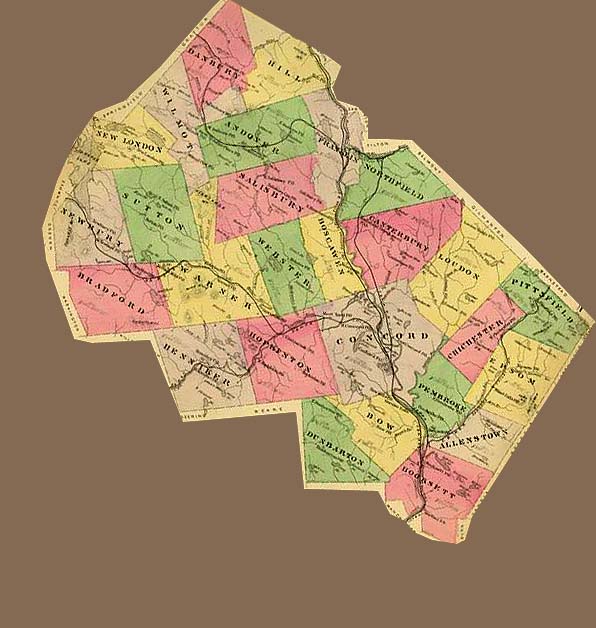
1877
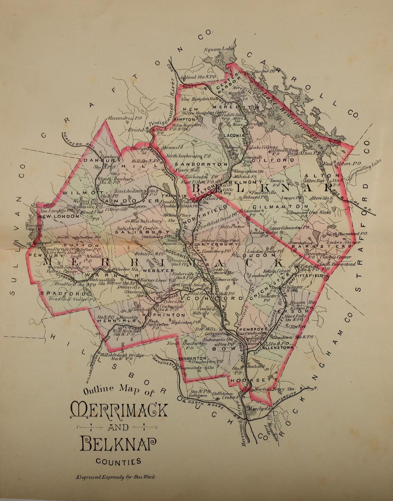
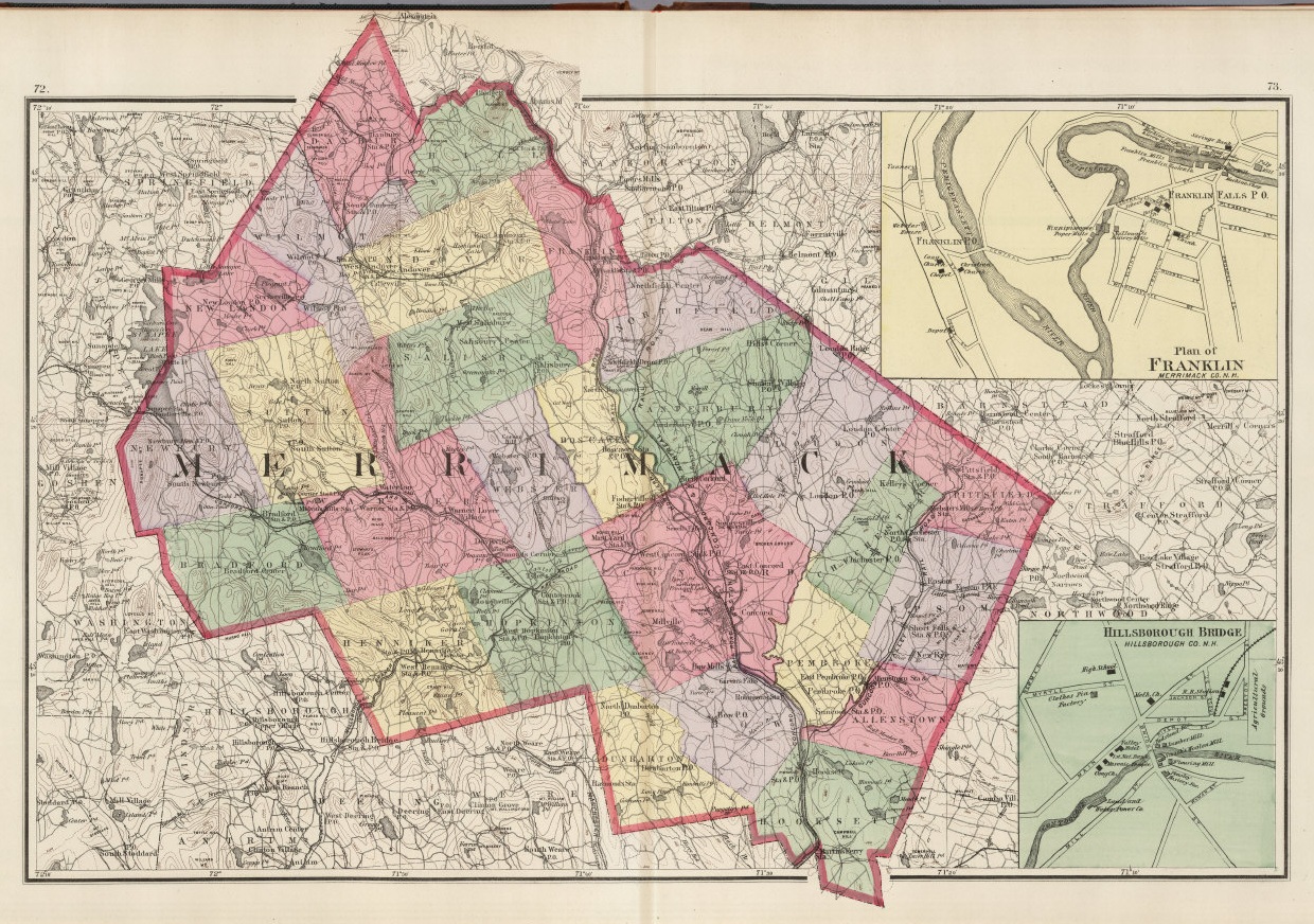
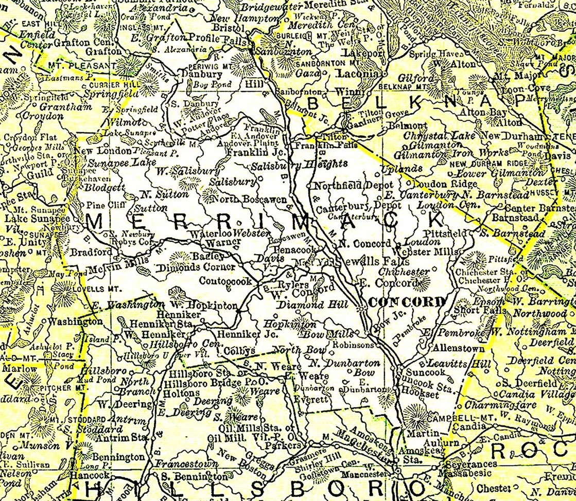
1885 Merrimack and Belknap Counties
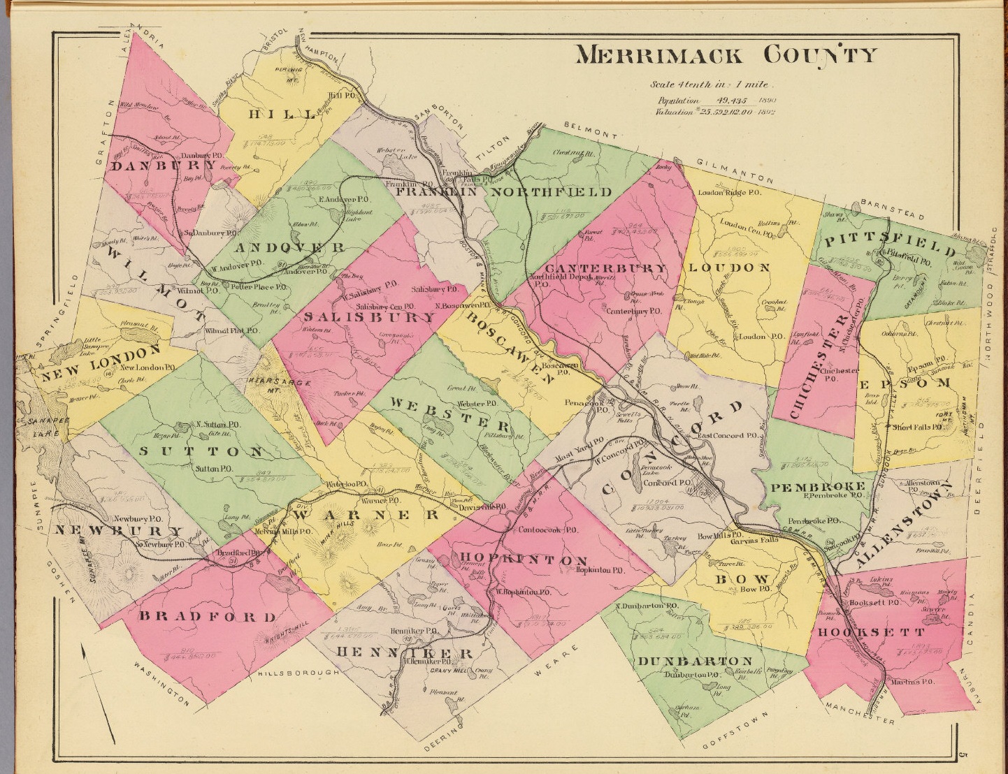
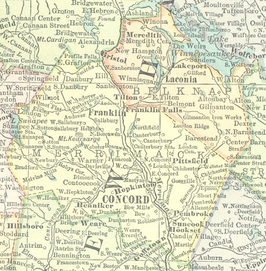
1892
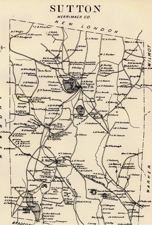
1892 Sutton
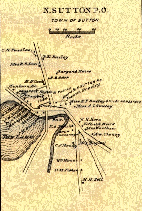
1892 North Sutton
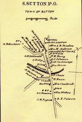
1892 South Sutton
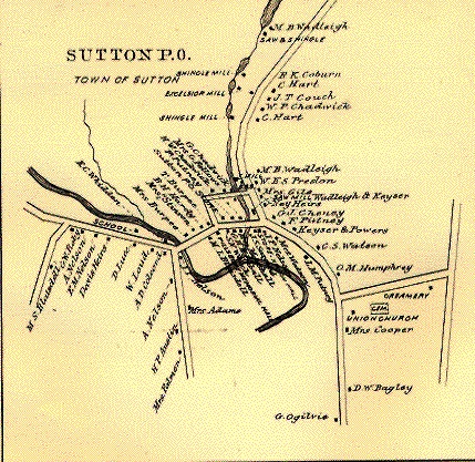
1892 Sutton Mills
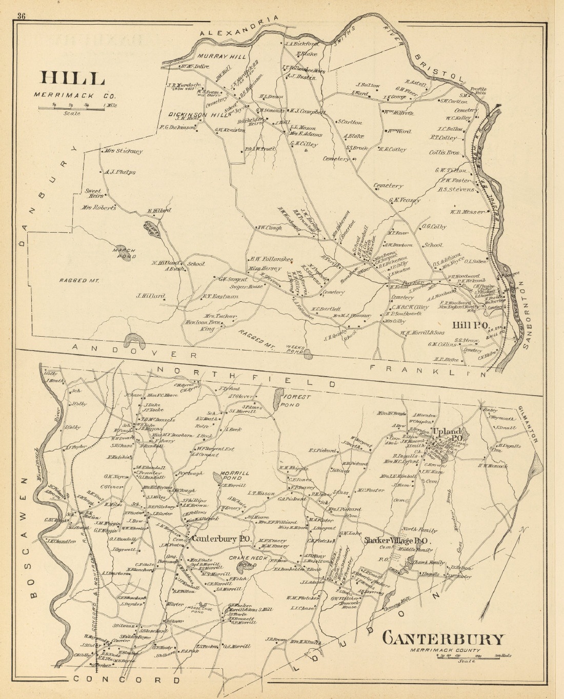
1892 Hill and Canterbury
1895 Rand McNally Atlas
1914 Atlas
Allenstown (1759)
Andover (1779)
Boscawen (1760)
Bow (1727)
Bradford (1787)
Canterbury (1727)
Chichester (1727)
Concord (1765)
Danbury (1795)
Dunbarton (1752)
Epsom (1727)
Franklin (1828)
Henniker (1768)
Hill (1837)
Hooksett (1822)
Hopkinton (1735)
Loudon (1773)
New London (1779)
Newbury (1837)
Northfield (1780)
Pembroke (1759)
Pittsfield (1761)
Salisbury (1768)
Sutton (1784)
Warner (1774)
Webster (1860)
Wilmot (1807)
Andover is a small, rural town in northern Merrimack County.
It was founded in 1779. Surrounded by mountains, ski areas, lakes, and camping
sites Andover is located 25 miles from Concord, 40 miles from Hanover and 90
miles from Boston. It has 26,000 acres and measures about 8 miles long and 4
miles wide. Prior to 1828, Andover was somewhat larger, including Webster lake &
what is now west Franklin.
The most visible landmark on the main street
of Andover is the Proctor Academy. This school, founded in 1848, has a
well-documented history. Its campus, located in a 250-acre central green, amid
the school's 2,000 acres of woodlands and mountain slopes, affords many
year-round activities. Proctor is a non-profit corporation governed by a
39-member board of trustees. Proctor Academy archives could offer an intimate
and interesting glimpse into past life styles in and around Andover.
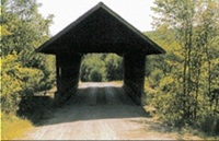 During the years 1870-1887 there were a total of seven covered bridges leading
in and out of Andover. All were built by local carpenters. Today, the Keniston
and the Cilleyville remain as reminders of a slower, and kinder life style. The
Keniston was built by a local carpenter by the name of Albert Atwood. He was
assisted by Al Emerson and Charles Wilson. Local folklore suggests that during
construction, Emerson and Wilson became upset and cut some of the timbers short,
causing the bridge to tilt. On the other hand, engineers might suggest that the
tilt is caused by the very nature of the town lattice truss design. The bridge
was the last covered, and probably the shortest built in Andover. It was
bypassed in 1959 and restricted to foot traffic. Located in the Cilleyville
section of Andover, it was originally known as Bog Bridge. A Cilleyville Bridge
was nearby, spanning the Blackwater River. After it was torn down in 1908, the
original Bog Bridge became known as the Cilleyville Bridge. The roof was
reshingled in 1962. On March 9, 1982 the roof caved in from excessive snow load.
The town repaired it in July 1982. The bridge was the model for the Shattuck
murals of typical New Hampshire scenes which were once located in the State
House in Concord. The Cilleyville Bridge is listed on the National Register of
Historic Places. In November 1998 state inspectors found the bridge to be in
danger of falling into Pleasant Stream, so emergency steps were taken to secure
the bridge. Two 90' steel beams were threaded through the bridge opening and
cross-beams were threaded through the lattice sides to take the weight off the
falling bottom chords and abutments.
During the years 1870-1887 there were a total of seven covered bridges leading
in and out of Andover. All were built by local carpenters. Today, the Keniston
and the Cilleyville remain as reminders of a slower, and kinder life style. The
Keniston was built by a local carpenter by the name of Albert Atwood. He was
assisted by Al Emerson and Charles Wilson. Local folklore suggests that during
construction, Emerson and Wilson became upset and cut some of the timbers short,
causing the bridge to tilt. On the other hand, engineers might suggest that the
tilt is caused by the very nature of the town lattice truss design. The bridge
was the last covered, and probably the shortest built in Andover. It was
bypassed in 1959 and restricted to foot traffic. Located in the Cilleyville
section of Andover, it was originally known as Bog Bridge. A Cilleyville Bridge
was nearby, spanning the Blackwater River. After it was torn down in 1908, the
original Bog Bridge became known as the Cilleyville Bridge. The roof was
reshingled in 1962. On March 9, 1982 the roof caved in from excessive snow load.
The town repaired it in July 1982. The bridge was the model for the Shattuck
murals of typical New Hampshire scenes which were once located in the State
House in Concord. The Cilleyville Bridge is listed on the National Register of
Historic Places. In November 1998 state inspectors found the bridge to be in
danger of falling into Pleasant Stream, so emergency steps were taken to secure
the bridge. Two 90' steel beams were threaded through the bridge opening and
cross-beams were threaded through the lattice sides to take the weight off the
falling bottom chords and abutments.
All of the
Andover vital records reside in Town Hall or in one of the two town Libraries.
Also available there for reference and research are several volumes covering the
early days of Andover.
The Andover Historical Society maintains a large
collection of historical documents pertaining to the town and its people.
Included are Town Reports from approximately 1860 to present, and Town records
(unindexed and difficult to read) on microfilm going back to the original Town
settlement.
Also, some of the older town cemeteries have been cataloged.
The two published Andover "Histories" provide a wealth of information. The
historical society also maintains a very interesting display of memorabilia at
the antique Potter Place railroad station. This display is, in fact, a living
museum in a building that played an important role in the development of the
area and its culture during the 19th Century. The museum is open to visitors
during the summer months on Saturdays and Sundays, and at other times by prior
arrangement.
The beginning of a railroad service was an important link
for Andover. Citizens gained access to places not normally visited. The Potter
Place Station was built in 1874 by the Northern Railroad in The Potter Place
section of Andover. It was named for Andover resident Richard Potter. Mr. Potter
was America's first professional magician and first African-American magician.
In 1890 the station was taken over by the Boston and Maine Railroad.
Then transportation modes once again changed, and evolved. Increasingly the
train fell into disuse, but service continued, until the last passenger train
that left Potter Place was as recent as 1962. Today the Potter Place station is
an important link with our heritage from yesteryear. It was transformed into a
museum of memorabilia.
The Andover Town Offices are in the historic old
school house building. Vital Town Records can be obtained from the Town Clerk.
The cemeteries in Andover are very numerous. By actual account, there
are 27 burying grounds for whose upkeep the town of Andover is responsible.
These plots or ground range from family buying grounds to large well-maintained
village cemeteries. The two most notable are the Lakeview Cemetery and the
Proctor Cemetery. A record of the "residents" buried in each of them is not
readily available because so many of them were private. Further information on
all of the local cemeteries and their residents is available at the library.
Contributed by Clifford L. Coy
Incorporated 1795, originally having been a part of Alexandria. Parts of Wilmot annexed 1848 and 1878 and parts of Hill annexed, 1858. --Shawn Perreault
The town of Franklin lies in the northeastern part of the county, and is bounded as follows: On the North and East, by Hill, Belknap Co. and Northfield; on the South, by Boscawen; and on the West by Salisbury and Andover. The territory embraced within the bounds of the present town of Franklin originally comprised a portion of the towns of Sanborton, Salisbury, Andover and Northfield. The first settlement of the town was made in 1748, near the Webster place, where a fort was built and occupied for several months. To Philip Call and his son Stephen is ascribed the honor of having been the first permanent settlers within the bounds of the present town, at that time a portion of Salisbury. --Herbert L. Girtman, Sr.
The first settlement was begun 1761, by Moses Ordway, Abraham Batchelder and Jethro Batchelder. Loudon was formerly a part of Canterbury from which it was taken and incorporated under the name of Loudon on January 28, 1773. --T. J. Rand
Prior to its incorporation as the town of New London, the tract of land was
known as Heidelburg. A 1768 map of New Hampshire, published in London England,
Heidelburg is shown. Early settlers called Heidelburg, when 137 lots of 150
acres each were drawn on September 7,1773. The lots that today comprise the
towns of both New London and Wilmot were acquired by a small group of men.
Surnames of those early land owners were Atkinson, Wentworth, Wibird,
Jaffrey, Meserve, Packer, Minot, Wallingford, Odiorne, Pierce, Moore and Moffat,
Thornton, Talford, McMurphy, Bagley & Ringe. These 16 or more freeholders were
the 1779 landholders of Heidelburg.
The first town meeting was posted by
Squire Messer on 3 August, 1779. Thirteen qualified voters met at Squire
Messer's dwelling house on Messer, (Knights) hill on that day. The election of
the town officers and other business made it official New London was now in
running order. The second town meeting was held March 14, 1780 with warrant
being signed by Samuel Messer, and Benjamin Eastman, selectmen.
New
London is a small town in West Central New Hampshire. It is situated midway
between Concord New Hampshire's Capital on the South and Hanover, home of
Dartmouth college to the North and Claremont to the West.
New London is
the home of Colby Sawyer college.
Contributed by Clifford L. Coy
Copyright © 1996 - The USGenWeb® Project, NHGenWeb, Merrimack County

This page was last updated
06/20/2026