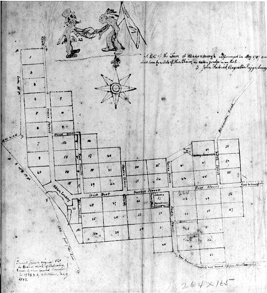

There are two roads on this map
that seem to run generally in the same area today. Extending northeast from
between Lots 59 & 58 (see layout below) is Edmonston Road, and the continuation
of the main east-west road is the Road to Annapolis (still called Annapolis
Road). If Edmonston Road is the same as the original, then early Bladensburg
extended just a bit past the shopping area containing the Rolling Pin Bakery.
To help clarify some of the fuzzy writing on this graphic of a photo of a
tracing of the original plat, I will describe the numbering scheme and include
the names of roads.
First locate the following:
Public Landing -
lower left of Plat where major north-south & east-west roads meet.
Tobacco
Warehouse - in sixth column of lots counting from the west (left), Lot #37.
Town Spring - small dot at the top of the seventh column.
Lot numbers begin
at the western side of town and are numbered from the north to the south for the
most part. (Lots 58-60 seem to be afterthoughts):
Column 1 - Lots # 1 - #
8 and Lot # 60
Column 2 - Lots # 9 - # 15, stopping at the Publick Landing
and West Street.
Column 3 - Lots # 16 - # 19, stopping at West Street.
Column 4 - Lots # 20 - # 22, stopping at West Street
Column 2 - (South of
West Street) Lot # 23
Column 3 - (South of West Street) Lots # 24 - # 26
Column 4 - (South of West Street) Lots # 27 - # 29
Column 5 - Lots # 30 - #
34, continuing across main roadway, now called Market Street.
Column 6 - Lots
# 35 - # 40, crossing Market Street & including the Tobacco Warehouse.
Column
7 - Lots # 41 - # 46, with Town Spring above Lot # 41. Main road now East
Street.
Column 8 - Lot # 59 and Lots # 47 - # 53.
Column 9 - Lot # 58 and
Lots # 54 - #57.
Between Columns 1 & 2: Water Street.
Running through Lots # 16 - # 19 in Column 3: Ross Street.
Between Lots # 23
and # 24: Fish Street.
Between Columns 4 & 5: Bladen Street, with Spring
Alley cut from Lot # 27.
West of Tobacco Warehouse: Market Place.
South of
Tobacco Warehouse: Market Lane.
Between Columns 6 & 7 (north of main road)
Spring Street.
Between Columns 6 & 7 (south of main road) South Street, which
continues on as Road toward Alexandria and toward Upper Marlbough [sic].
Between Columns 8 & 9: North Street, which becomes Edmonston Road.
Between
Lots # 11 & # 12: Cross Street.
Between Lots # 59 & # 47: Spring Lane.
Between Lots # 44 & # 45: just called Lane, with no name.
Richard Snowden, Jr.
Samuel Thomas
Stephen Martin
Samuel
Snowden
Nathaniel Folsom
Osborn Sprigg
Ninian Mariarte
Edward
Lowndes & Co.
Thomas Waring
Michael Higgons
Matthew Hopkins
Edward
Trafford
John Skinner
Thomas Gantt, Jr.
Reserved for Miss Calvert,
proprietor of the land
Francis Lowndes
George Scott
Dr. George Riddle
Dr. David Ross
Nicholas Baker
William Digges
Thomas Chittam
Thomas
Williams, Sr.
Capt. James Edmonston
Thomas Snowden
Richard Snowden, Sr.
Thomas Owen
John Needham
Thomas Cramphin
Reserved for Miss Calvert
Nicholas Digges
William Hilleary
John Gittings
Samuel Beall, Jr.
Dr.
George Cooke
James Haddock Waring
Richard Gildert
Francis Finn
Major
Jeremiah Belt
Samuel Galloway
William Thomas
John Hawkins, Jr.
William Murdoch, Esq.
John Row, Jr.
Joseph Belt, Son of John
John
Brashear
Kennedy Farrell
Benjamin Young, Esq.
John Row, Sr. (8 Jul
1743)
Charles Digges
Christopher Lowndes
Nehemiah Ogden
William
Mauduit
Col. Edward Sprigg
Thomas Hilleary
Thomas Butler
Edward
Sprigg the 3rd
Capt. James Edmonston, Osborn Sprigg, William Mauduit, Thomas
Gantt and Thomas Waring conducted the sale of the lots on 15 Mar 1742.
Purchasers were required to improve the land within 18 months. Each lot occupied
an acre.
Contributor: Unknown
Copyright © 1996 - The USGenWeb® Project, MDGenWeb, Prince George's County