

|
|
|
|
County Coordinator: Vacant
| HOME
| ARCHIVES |
BIOGRAPHIES |
BOOKS & NEWSPAPERS | CEMETERIES |
CENSUS | CITIES |
HISTORIC PLACES
HISTORY | LAND GRANTS | LIBRARIES | MAPS | MILITARY | RESOURCES | VERTICAL FILES | VITAL RECORDS | VOLUNTEER |
MAPS
|
TOWNSHIP AND RANGE MAP OF CALHOUN COUNTY courtesy of Duke Vikrey 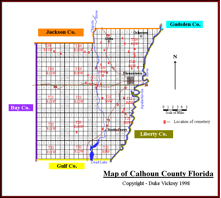
|
|
Projection: Unknown Source Bounding Coordinates: W: E: N: S: Description: This detail of a map of Florida shows railroads and major cities and towns current to 1932 for Calhoun County. Major waterways are shown, as well as lakes, town, islands, and marsh. Other notable features are Seminole Indian Reservations, canals, and railroads. Features included in this detail are the Chipola River, Bloutstown, and Clarksville. Place Names: Calhoun, Chason, Carr, Altha, Selman, Blountstown, Clarksville, Frink, Breadbranch, Myron, Kinard, Scotts Ferry, Chipola River, ISO Topic Categories: boundaries, transportation, inlandWaters, oceans Keywords: Calhoun County, physical, political, transportation, swamps, everglades, wetlands, physical features, county borders, railroads, boundaries, transportation, inlandWaters, oceans, Unknown,1932 Source: , (, : US Department of the Interior Geological Survey, 1932) Map Credit: Courtesy the private collection of Roy Winkelman. |
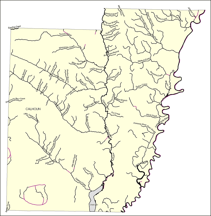 Florida Waterways: Calhoun County Outline, 2008 Florida Waterways: Calhoun County Outline, 2008
Description: This map was created by FCIT and shows the waterways of Calhoun County. All major rivers, streams, creeks, lakes, and swamps are labeled. This map features May Mill Creek, Hansford Branch, Ring Jaw Branch, Hollis Branch, Holliman Branch, Boardhead Branch, Farley Creek, Taylor Branch, Otter Creek, Simmons Creek, Stafford Creek, Sutton Creek, Thomas Mill Creek, Graves Creek, Wilson Mill Creek, Flowers Creek, Ocheesee Creek, Johnson Creek, The Bayou, Big Brook, Davis Mill Creek, Boogy Branch, Chipola River, Ammonia River Sand Slough, Hicks Creek, Apalachicola River, Hogpen Branch, Wildcat Creek, Fox Creek, Dead Lake, Pitts Mill Creek, Woods Branch, Crooked Creek, Cypress Creek, Broad Branch, Pole Branch, Clearwater Branch, Sandy Creek, Little Cypress Creek, East Prong Bear Creek, Bailey Branch, Jumper Creek, Watson Branch, Centerfit Branch, Huey Branch, Palmetto Branch, Panther Branch, Fourmile Creek, White Water Creek, Tenmile Creek, Econfina Creek, and Mayo Mill Branch. Place Names: Calhoun, May Mill Creek, Hansford Branch, Ring Jaw Branch, Hollis Branch, Holliman Branch, Boardhead Branch, Farley Creek, Taylor Branch, Otter Creek, Simmons Creek, Stafford Creek, Sutton Creek, Thomas Mill Creek, Graves Creek, Wilson Mill Creek, Flowers Creek, Ocheesee Creek, Johnson Creek, The Bayou, Big Brook, Davis Mill Creek, Boogy Branch, Chipola River, Ammonia River Sand Slough, Hicks Creek, Apalachicola River, Hogpen Branch, Wildcat Creek, Fox Creek, Dead Lake, Pitts Mill Creek, Woods Branch, Crooked Creek, Cypress Creek, Broad Branch, Pole Branch, Clearwater Branch, Sandy Creek, Little Cypress Creek, East Prong Bear Creek, Bailey Branch, Jumper Creek, Watson Branch, Centerfit Branch, Huey Branch, Palmetto Branch, Panther Branch, Fourmile Creek, White Water Creek, Tenmile Creek, Econfina Creek, Mayo Mill Branch ISO Topic Categories: boundaries, inlandWaters Keywords: Florida Waterways: Calhoun County Outline, political, physical, kriversandstreams, physical features, county borders, photograph in shape of map, photo, Florida mapboundaries, inlandWaters, 2008 Source: Florida Center for Instructional Technology, (Tampa, FL: University of South Florida, 2008) Map Credit: Courtesy of the Florida Center for Instructional Technology |