

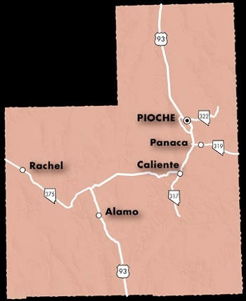
Lincoln County
NVGenWeb

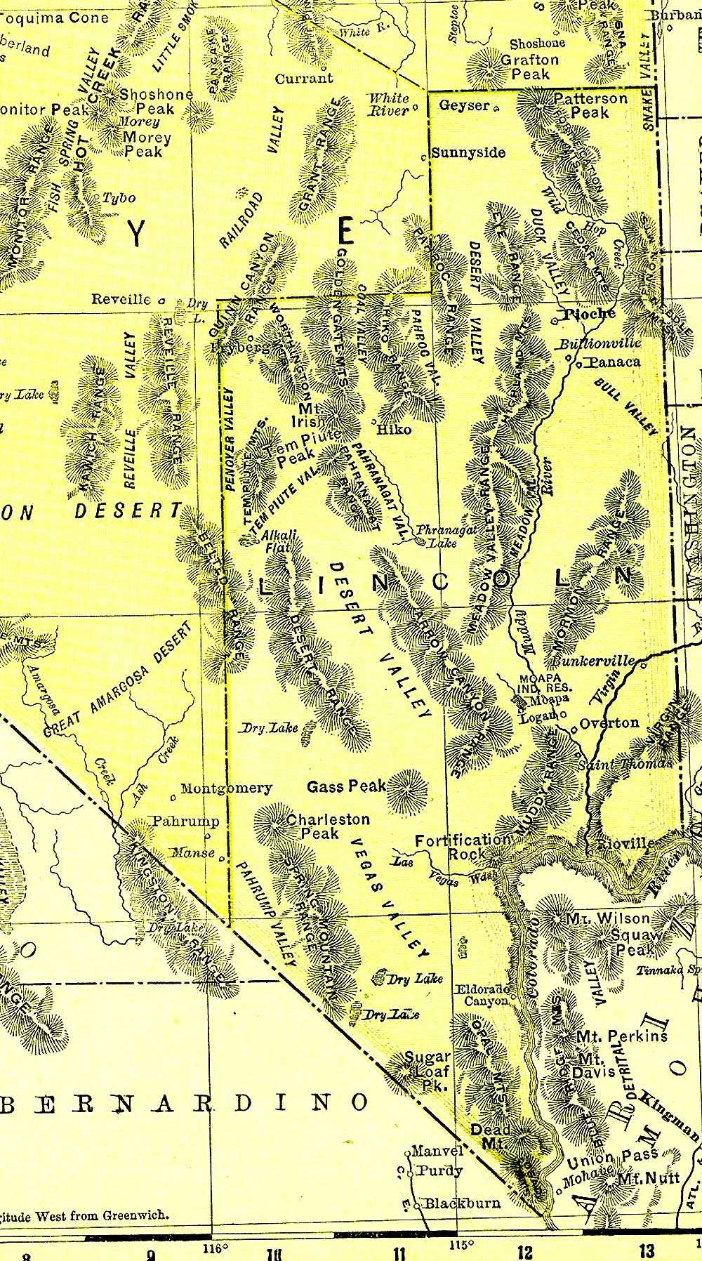
1895 Lincoln County
Southern portion went to form Clark County in
1905
Map courtesy of Nevada Department of Transportation
The listing below includes historic sites so if your research leads you to a town that isn't on the map, check it out here! Mining and the Railroad had a great deal to do with settlements that grew up in Nevada. Many names are in actuality railroad sidings or stops where the railroad would pick up workers, get water, and some work crews lived there. This was prior to electricity. If you know anything about Nevada history, you know that "boom and bust" was the way it went!
Acoma ~ Mining Camp; 26 miles east of Caliente
Alamo ~ Pahranagat Valley
Angle City ~ near Vigo
Ash Springs ~ Pahranagat Valley north of Alamo
Atlanta ~ 4 miles NE of Pioche; Est. October 1907. Also called Silver Peak & Silver Springs
Barclay ~ Clover Valley; 19 miles NE of Caliente;
Photos and info
Big Trees ~ Highland Peak
Boyd ~ North of Elgin; Railroad Station
Bristol ~ 16-20 west of Pioche; Railroad Station also called Jackpot;
Photos and info
Bristol City ~ about 25 miles northeast of Pioche
Bristol Well (Historic) ~ 23 miles north of Pioche
Brown ~ near Acoma
Bullionville (Historic) ~ 10 miles south of Pioche; also called Ely City;
Private Property
Bunkerville ~ now in Clark County, 35 miles northteast of St. Thomas
Caliente ~ est. 1857 as Culverwell's Ranch; Also called Clover Junction;
Photo and info
Callville ~ on the banks of the Colorado River
Carp ~ 38 miles south of Caliente; orig. Cliffdale. Est. 1907;
Photos and info
Caselton ~ south slope of Ely Mountain; est. 1920's by Combined Metals Reduction Co.;
Photos and info
Cave Valley (Historic) ~ East of south Egan Range; was called 3 Butte Valley
Cedarhurst (Historic)
Cold Spring
Coyote Spring (Historic) ~ old campsite west of Hoya
Crestline ~ 34 miles NE of Caliente; non-agency railroad siding
Crossroads ~ NE of Caliente
Crystal Springs ~ south of Hiko; First County Seat
Deer Lodge (Historic) ~ est. 1898 15 miles east of Pioche
Delamar ~ orig 1892 as Reeves;
Photos and info
Delmue(s) (Historic) ~ 9 miles SE of Pioche; non-agency station for UP RR
Eccles ~ bet. Minto & Caliente; UP RR siding in Clover Creek Canyon
El Dorado ~ now in Clark County
Elgin ~ 20 miles south of Caliente; est. 1913;
Photos and info
Etna ~ 4 miles SW of Caliente; UP RR station
Fay (Historic) ~ Mining camp at UT-NV stateline;
Photo and info
Ferguson (Historic) ~ Delamar; renamed Delamar or De Lamar
Flat Nose ~ Rose Valley
Freiburg (Historic) ~ 75 miles west of Pioche; est. 1865 in Coal Valley
Galt ~ 10 miles south of Carp; non-agency RR station
Geyser (Historic) ~ 75 miles north of Pioche; Ranch est. 1889
Groom (Historic) ~ 30 miles from Yucca Flat; Est. 1850 - on Government Land
Helene ~ 1 mile north od Delamar; Named for Ferguson's wife;
Photos and info
Highland (Historic) ~ 7 miles NW of Pioche
Hiko ~ Pahranagat Valley-north end; 2nd County Seat Est. late 1860's
Hoya ~ 20 miles north of Moapa; Railroad siding
Indian Cove
Islen ~ 16 miles NE of Caliente; Clover Valley RR siding
Jackrabbit (Historic) ~ 20 miles north of Pioche; Also called Royal City;
Photo and info
Joseco ~ SE of Caliente; Clover Valley
Junctionville ~ twenty-five miles northeast of Callville, a few miles south of St. Thomas
Karo (Historic) ~ Trail Canyon; 1917 to 1918
Kershaw (Historic) ~ So of Caliente; Existed 1892-1904
Kiernan (Historic) ~ 5 miles south of Elgin; Ranch est. 1870 by John Kiernan
Kyle ~ 4 miles south of Elgin; UP RR siding in Meadow Valley Wash
Leith ~ 10 miles south of Elgin; Non-agency RR station
Logan (Historic) ~ now in Clark County, 10 miles west of Hiko; Est. 1865;
Photos and info
Mendha ~ 4 miles NW of Pioche; RR siding
Midey Valley (Historic) ~ NW of hiko & west of Caliente
Montezuma (Historic) ~ west of Patterson
Mud Springs ~ NE of Elgin; Railroad siding
Newland (Historic) ~ Bet. Pioche and Stateline; 1896 - 1912
Ninemile Rocks ~ Panaca Summit
Oneota (Historic) ~ at junction bet roads to Pioche, Hiko & Cherry Creek; Est 1909 in Coal Valley
Overton ~ now in Clark County
Panaca ~ SR 25, 15 miles from Caliente; Est. 1864. Southern Paiute word meaning metal
Patterson (Historic) ~ 50 miles south SE of Ely; Est. 1887
Pioche ~ County Seat; previously called Ely;
Chamber of Commerce;
Photos and info
Pony Springs ~ 25 miles north of Pioche; Pony Express Stop
Princeton (Historic) ~ near Pioche; Existed 1909-1910
Rachel ~ near area 51-Test site, originally called Sandy
Richardville ~ Near Alamo; Small farming community Est. 1860's
Rioville ~ now in Clark County beneath Lake Mead
Rose Valley ~ Ursine Valley
Rox ~ 15 miles north of Moapa; UP RR station est. 1902
Royal City ~ bet. Bristol and Pioche; Jackrabbit
Silver City ~ Bet. Hiko & Ash Springs; on old map
Spring Valley (Historic) ~ Hot Springs; Est. 1866; Formerly
in Roop County
St. Thomas ~ now in Clark County, 7 miles southeast of Overton
Stine ~ Bet. Etna and Boyd; UP RR siding Meadow Valley Wash
Strawberry Hill ~ Near Caliente
Sundown ~ White Blotch Springs NE
Tempest (Historic) ~ Bristol; Est. 1922
Tempiute ~ Also called Timpahiute; Est. 1868
Ursine ~ 13 miles NE of Pioche; Farming community in Eagle Valley est. 1863
Viola (Historic) ~ Meadow Valley Wash
Wilson Creek ~ NE of Pioche
Yoachum (Historic) ~ near Caliente; Archie Yoachum Ranch 1893-1902
Copyright © 1996- The USGenWeb® Project, NVGenWeb, Lincoln County
Design by Templates in Time
This page was last updated 02/01/2024