- About Lunenberg
- African Americans
- Burials
- Census
- Churches
- Communities
- Miscellaneous
- Families
- History
- Houses & Landmarks
- Land
- Maps
- Marriages
- Resources
- Schools
- Taxes
- Wills
Old Bailey Place

Site being researched
Additional information welcomed
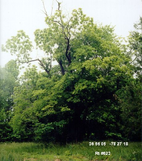
Year 2001 - The above very old walnut tree is on an old home site owned by A. E. and Mary Frances Bailey. In recent years the place has been known as the Old Bailey Place and Old Wallace Place, according to Carter Thompson of Fort Mitchell. The tree stands in a clearing off Rt #623 near Knight's Creek (historically, Pledger's Fork).
Mr. Bailey said a few years ago the old walnut tree didn't have a leaf on it. He thought of cutting it down. The following year it came back, waiting for us to share in its beauty.
The short road from #623 to the clearing is in rough shape, but drivable in 2001, if you stay high and out of the ruts.
To the right of the clearing are two very old buildings in a state of decay. See below photo to the right.
Almost straight on, shown in the below photo to the left, is the edge of a wooded area behind which is a large cemetery, according to Mr. Thompson, and which cemetery contains the grave and tombstone of Rev. John Williams (see his family). I hope we can revisit the cemetery in the fall when the snakes are sleeping and the leaves have fallen.
This clearing and old walnut tree seem to be about where the name "W. Knight" appears on the 1864 Gilmer Confederate Map, Section 16.
Update 17 Aug 2003: Gerald Reinders, with Jack Gregory, recently visited
a cemetery in the woods in the general direction of the site above where
coordinates were recorded N36degrees 56.105' latitude and W078degrees
27.286'. Found were:
Williams, John Watts b. 6-12-1847 d. 3-8-1914
Williams, Prescilla J. b. 12-8-1808 d. 12-30-1875
Williams, Robert H. b. 1-1-1804 d. 8-27-1877 (see
Williams family register)
?? , Matthew W. Rest unreadable.
Enlarged images are missing

|

|

