
Return to the VAGenWeb Project Charlotte Co.Home Page
Return to the Charlotte County Church Page
JoLee Gregory Spears
(This page was last updated )
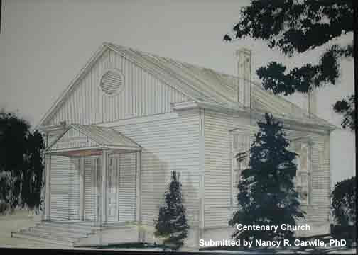
Centenary Church
Charlotte County, VA
Submitted by
Nancy R. Carwile, PhD
The current major north-south route visible to the left is now called State Route 47, Thomas Jefferson Hwy. Chickentown was the former name for Madisonville (current Topo map). Cockfights were held either at Harvey's Store on the left or in front of the old "Brick Tavern is on the right. The northernmost road to the east was the direct road to Prince Edward court house. The next road south of the Prince Edward road is now named "Crawley Road" (Hwy 649). This road, currently running parallel to State Route 47, is the old road to Charlotte Court House. Either 649 or 47 may have been the old "Chickentown Road" noted in some old deeds, but a comparison of modern maps with an 1827 map suggests that 649 is the old "Chickentown Road." Republican Chapel was originally on the road to Charlotte Court House, and was moved on rollers, and pulled by oxen, through the woods to its current location on Rolling Hill Rd (615). The map is damaged, so that the "R" is missing from "Republican"; the exact location of the church is either not marked or no longer visible. We have found no deed for the church at the "old" site, but it may have been on the property listed on this map as belonging to J. R. Ford. Since Ford is a prominent name among members of Republican Chapel/Centenary, the original site was likely on property originally owned by J. R. Ford or his forebears. If the land changed hands around 1849, that would account for moving the building. In September 1837, James Ford, his wife Mary, and Thomas G. Ford sold land near Rattlesnake Creek to Thomas R. Marshall. This land ran from Thornton's Mill to Nathan Harvey's corner. T. R. Marshall is noted on the map to the left of the "Republican Chapel" notation. This may have been the tract from which the acre for the church was taken. The date when the church building was actually moved is uncertain. The deed of gift, from Thomas R. Marshall to the Methodist Episcopal Church, South for the sum of $1.00, was recorded as June 29, 1850. Mrs. James Morris's account in 1949 notes that the church building was already on the property when the deed was drawn up. However, she also states that the building was moved "sometime after the war." "The war" has been assumed to mean the War Between the States, but the building was evidently moved before that conflict. Mr. Fleming Branch (1836-1907) is quoted as having walked, as a young child, with his sister to Sabbath School at the old location. He would have been a young child in 1849 but not after 1864. Nancy Harvey Branch (1814-1896), his mother, and wife of John T. Branch, is buried at Centenary, and "Mrs. Nancy Branch" is noted at the bottom of this map section, within walking distance of the old site and of the new location. On March 23, 1883, Luther Rice Ford (1836-1917) and his wife Pernette Smith Ford (1837-1906) obtained title to the land previously owned by Thomas R. Marshall. D. Q. Eggleston is listed as Commisioner of the Court. [Perhaps the land changed hands upon the death of Mr. Marshall, or for debts incurred after the War?] There is no mention of the acre of land for the Republican Chapel. In 1891, a second deed to the church is recorded, which notes that "Whereas Thomas R. Marshall in his life time did by deed dated 29th June 1850 convey to Thomas Pugh [et al], Trustees for the Methodist Episcopal Church South on a lot of land....." and notes that L. R. Ford had purchased the whole of that property in 1883. Possibly the second deed was prompted by the 1890 contract with Joel H. Jones for renovating the old church. Luther Ford was a member of Republican Chapel, is buried in the Centenary cemetery, and there was apparently no concern about the confusion of title for the previous 18 years. The original church was an unpainted unheated building, with a large gallery for slaves. The benches were slat-backed wooden ones, and on each side of the building from the two entrance doors there was an aisle. The entrance doors were originally on the south side of the building. The contract with Joel H. Jones for renovations, dated April 12, 1890, calls for him to "turn the present House around if need be..." and stipulates the renovation in careful detail. Because the present north entrance has but one double-door opening in the center, and because there is an exit door to one side of the present recessed pulpit area, we can assume that Mr. Jones did not need to literally turn the church on its foundation. Rather, it appears that the recessed pulpit was built where the old slave gallery had been, and one of the old entrance doorways is now the exit beside the pulpit. A new entrance door, described in the contract and still in place, was added to the north side of the building. The chimney flue was then put in the ceiling at the center of the church, and a stovepipe, suspended with wires, ran from heaters on the sides to the central flue. Other details may be seen in the attached contract. On February 21, 1899, Luther Ford and his wife deeded additional land, this time for $5.00, so that the growing church had more room for a cemetery. There are only seven (7) marked graves in the cemetery of persons who died before 1899, and those graves are within the original acre. Only one person, Nannie Bradley DeFord (1859-1883) was buried before the church was turned around in 1890. A preference for placing persons in the rear of the church rather than near the front door may have prompted the decision to "turn the church around." Most likely the older Fords, Branches, and others were buried either in family cemeteries or near the older site church site on the road to Charlotte Court House. Those graves have since been lost. Of further interest: The property north of the old church site is that of a "Mrs. Wood." Thomas Wood married Elizabeth H. Harvey in 1818. Elizabeth was the daughter of Isham Harvey, and there are several deeds recorded from that time with Isham Harvey, Thomas Wood, and/or John Harvey, Isham's son, as signatories. Isham Harvey and his son John were the builders and proprietors of Harvey's Store and Harvey's Tavern, two buildings which still stand in Madisonville (formerly Chickentown). A retail merchant's license is listed for Isham Harvey & Co in 1827, and in 1831, a license for a "house of entertainment" was issued to John Harvey of Chickentown. It was thought that the cockfights were held in a pit in front of the old brick tavern. The "Mrs. Wood" noted on this map is most likely Elizabeth. Her name appears on several deeds after 1864. One deed notes that she had inherited 1/7 of Isham Harvey's estate. In November 1859 she sold land to James T. Crawley "upon the waters of Wordsfork [sic] Creek" for $215.62 ½. James Crawley (1932-1893) served in the Confederate Army and is buried in the Centenary cemetery. "J. Crawley" is noted on the map, and Crawleys lived there until the late 20th century. The Crawley family (also buried in the "new" cemetery) owned some property on both sides of Rt. 649 until the late 20th century. Mr. J. Henry Hamilton (1900-1985)'s mother was Mattie Pollard Hamilton (1866-1959). Henry said that a Yankee scouting party crossed the property here noted as "Wood." Young Henry was raised on Pollard property on the west side of the creek, and east of the road from Chickentown to Charlotte Court House. A large two-story brick house with an English basement was located near the spring. (The old house was heated with fireplaces. Mr. Hamilton said that a pitcher of water would freeze on the mantel while a fire burned below it.) The house itself has since burned, but the property is still called the "Pollard Place." When Mattie Pollard married Mr. Hamilton, 103 acres were cut off from the property for the newlyweds to build a new house, and that farmhouse stands today. |