
This is a Dawson County NEGenWeb Project web page
and is presented as part of the
MARDOS Memorial Library Collection.
|
structed and completed the Thirty Mile Canal, a project costing $350,000.00. There was no irrigation district formed and no bonds were issued. There is no indebtedness of any kind against the project. This group of 121 farmer stockholders made their own arrangements, put the undertaking across and paid for it. Fifteen months after the first meeting the project was completed and at a cost of something less than $25.00 per acre. Extraordinary. And considering the manner and means, especially noteworthy. An outstanding example of co-operative accomplishment. Twenty-five dollars -- the value per acre of one good dry-land wheat crop. If Providence had started out to arrange ideal conditions for a garden spot under irrigation, the territory covered by the Thirty Mile Canal could hardly be improved upon. Leaving the south shore of the Platte river about ten miles west of Gothenburg, the canal flows southeast, following the contour of the clay hills along the southern edge of the Platte valley for a Leaving the south shore of the Platte river about ten miles west of Gothenburg, the canal flows southeast, following the contour of the clay hills along the southern edge of the Platte valley for a |
 |
|
SCENE ON THIRTY MILE CANAL CO. PROJECT |
|
Showing type of modern cement and steel highway bridges used on the project; also a check just beyond the bridge. An excellent example of the land under the canal. Perhaps nowhere does land lie in such manner as to be irrigated with as little labor and cost. |

 |
|
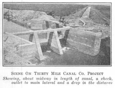
SCENE ON THIRTY MILE CANAL CO. PROJECT |
|
Showing, about midway in length of canal, a check, outlet to main lateral and a drop in the distance |
|
distance of thirty-three miles, the waste waters returning to the Platte ten miles east of Cozad. This range of clay hills, covered with luxuriant grass, is several miles in width and forms the divide between the Platte and Republican valleys. For fertility and depth of soil the land lying under the Thirty Mile Canal is not surpassed anywhere in Nebraska. It is a rich, heavy black loam, under-laid with an excellent subsoil of great depth, and especially suitable for the cultivation and production of alfalfa, sugar beets, corn, winter wheat and other small grains. From the canal the land slopes gently north to the Platte river and the river and the valley have a fall to the east of about six feet to the mile. Probably no body of land of this extent anywhere is so situated as to be irrigated with as little labor and cost. The width of the Thirty Mile Canal tract varies from two to four miles, and practically all of the acreage can be watered. Of the land in this tract, 15,000 acres have water rights under the canal and water is now on the land, and the canal has sufficient capacity and was built to water 10,000 additional acres. The Platte river, along the north edge of the project, is a stream about one mile wide. New cement bridges of the most modern construction cross the |
 |
|
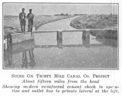
SCENE ON THIRTY MILE CANAL CO. PROJECT About fifteen miles from the head |
|
Showing modern re-inforced cement check in operation and outlet box to private lateral at the lelt. |
|
river at Cozad and Gothenburg. These cities are located on the north side of the river and lie about eleven miles apart. They are the marketing and trading points for the Thirty Mile Canal territory. Both are good live towns with populations approximating 2,000 each, enterprising and progressive communities. Both have fine churches and school buildings with accredited high schools. On the main line of the Union Pacific railroad and the Lincoln highway, they are connected by excellent graveled roads that cross the county east and west and are part of the main highway through Nebraska from coast to coast. The Midway Ranch, chosen as the site of the dedication ceremonies, was a part of the holdings of Curtis & Black, extensive owners in the nineties of ranch properties at various points. It is located about the middle of the project east and west and is about equally distant from Gothenburg and Cozad. Part of the ranch land is irrigated from the canal and from the elevation of the ranch buildings the Thirty Mile Canal project is visible for miles in three directions. The old Oregon Trail traversed the land now irrigated by the Thirty Mile Canal, also the Pony Express line. At least one of the original log express stations, built in the fifties, stands in a good state of preservation on land that lies under the canal. |
| Back | Title Page | Next |
| Home | Queries | Resources | History | Search |