The History of Caroline County, Maryland, From Its Beginning
The Mason Dixon Line

In the present state of Delaware the Swedes settled first, then the Dutch wrestled it from them. Later, in 1682 a special grant was made from the Duke of York to William Penn giving him the Delaware section. In 1685 this grant was duly confirmed. Proprietary Maryland refused to submit so that up to the year 1732 there was ceaseless litigation as well as an occasional outrage along the border.
Reverting to the earlier contention we find that in 1681 the "Three Lower Counties," (now Delaware) settled the northern boundary separating them from Pennsylvania as follows: With New Castle for a centre and using a 12 mile radius the arc of a circle was drawn, the line thus made forming the northern boundary then as now.
But the Maryland-Pennsylvania dispute continued and finally in 1750 it was settled by "map," but on real land the location of the boundary was indefinite. Both Penn 's heirs, and Frederick, Lord Baltimore, wanted it settled in a manner that would last for all time. The following survey of the Eastern boundary was made locating it definitely.
Recognizing the 38o parallel as the Southern boundary of Maryland it was then decided to find on this the middle point between Delaware and Chesapeake Bays and from this run a North line which should form a tangent with the New Castle "arc" at its most westerly point. This was done and the line forms the Eastern boundary of Caroline County as well as of the state.
Many interesting facts are connected with the running of this line bv the surveyors, most of which are recorded in a series of letters written by Gov. Sharpe of Maryland to Lord Baltimore.
In a letter dated June 22, 1761, Gov. Sharpe states that the surveyors, running the Maryland-Delaware line from the "middle point" before mentioned found that on reaching a distance of 25 miles north they were unable to take further observations because they could find no star by which to set their transits. Moreover at the same time they became sickly with Maryland fever from
having been so long a time in a dismal part of the country abounding in swamps. [They were in the Hickman and Smithville section]. As a result of the letter the surveyors were instructed to discontinue for a time.
As a conclusion of the above, Sharpe writes Aug. 17, 1761 stating that on Aug. 9 the surveyors, evidently recovered from Malaria, were able to make observations by Alioth and the Polar Star, accordingly were proceeding up the peninsula with the line, believing they would not again be interrupted until they reached Newcastle.
On Sept. 5 they found themselves 44 miles to the north and were hoping to reach Newcastle in October but it was a case of hope deferred for again on October 22 Sharpe writes that they had been often interrupted by wet and cloudy weather and had not yet extended the line more than 77 miles of the distance necessary, hence, imagine the remaining distance can be run in 10 or 12 days. The exact day of completion is not given but the account states that, Nov. 12, 1761, the north and south line has been completed, and they were preparing the tangent ready for the west line.
The fact of 12 days being necessary for the running of a 6 mile line shows the difficulty of the work at that time. Instruments were scarce, and less perfect than now and mayhap surveyors less expert. Moreover in this case the direction of extra work devolved on the surveyors. To proceed through the forest it was necessary to open a way. This was done by cutting a roadway or "vista" 8 yards wide along the line to be surveyed, as well as the setting of the stone line marks.
While not connected directly with Caroline County, it might be well to mention here the Mason and Dixon line as Maryland's northern boundary. It was on this line that Charles Mason and Jeremiah Dixon put their personal work, and for them the entire line was named. Coming over in 1763, they had perhaps even more trials than the surveyors of the North and South Line, for the Indians of Southern Pennsylvania added to their danger.
The East and West Line began 15 miles south of Philadelphia, connecting with the North and South Line at its point of tangency with the Newcastle arc, west along the entire boundary of Pennsylvania.
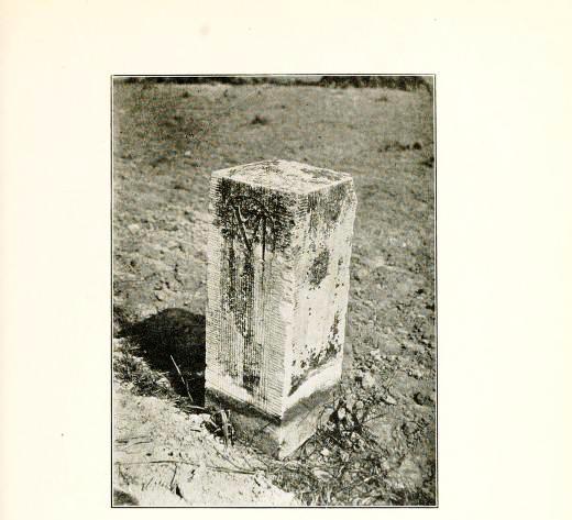
And so the historic Mason and Dixon Line was run. It is marked from the "middle point" to the Newcastle tangent and thence to the western limit of Pennsylvania by square mile stones, for successive having on one side M and on the other P, while on the fifth stone on the Maryland side has the coat of arms of the Baltimore's and the reverse side that of the Penn's. Such is the story of the Mason and Dixon Line which someone has said, "Next to the Equator is the most widely known line in the world."