North Dakota Post Route Map 1911

Showing present day Morton, Grant and Sioux counties


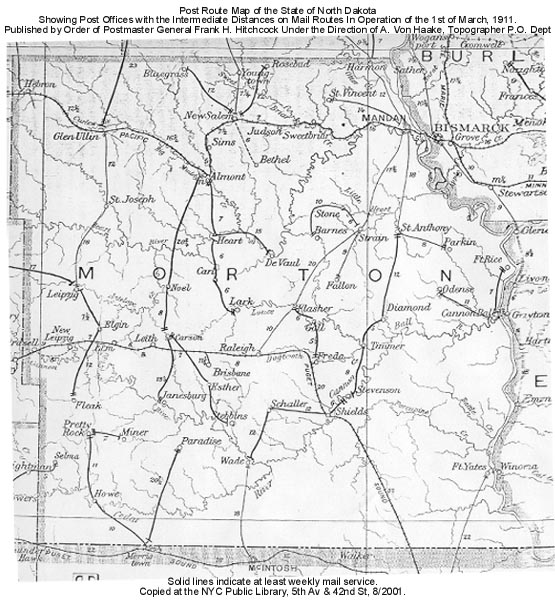
Which county would these places be in today? See below.


  • Birdsell
  • Brisbane
  • Carl
  • Carson
  • DeVaul (?)
  • Elm
  • Elgin
  • Esther
  • Fleak
  • Freda (?)
  • Heart (?)
  • Howe (*)(1)
  • Janesburg (*)
  • Lark
  • Leipzig (*)(2)
  • Leith
  • Miner
  • Noel
  • New Leipzig
  • Paradise
  • Pretty Rock
  • Raleigh (3)
  • Schaller
  • Selma
  • Shields
  • Stebbins
  • Stevenson (*)(?)
  • Wade (*)(1)

Morton county(northern part of map)
  • Almont
  • Barnes
  • Bethel
  • Bluegrass
  • Cannon Ball (*)
  • Diamond
  • Fallon (*)
  • Flasher
  • Ft. Rice (*)
  • Gall (?)
  • Glen Ullin (*)(1)
  • Harmon (*)
  • Hebron (*)
  • Judson
  • Mandan (*)
  • New Salem (*)
  • Odense
  • Parkin
  • Rosebud
  • St. Anthony
  • St. Joseph (?)
  • St. Vincent
  • Sims (*)
  • Stone
  • Strain
  • Sweetbriar (*)(2)
  • Timmer (?)
  • Youngtown
(1) Spelled Glenullin on 1900 map (2) Spelled Sweetbrier on 1900 map
(*) Also listed on 1900 map (?) I'm not sure I've got the right present-day county.


Sioux county (south of the Cannonball River)
  • Fort Yates