Maine Old Cemetery Association (MOCA). Waldo County Cemeteries located on
Maine township road maps. [chiefly charts and maps] Contributed by many, c1981.
BELFAST
(G. R # = Reference from Belfast Vital Records (pub. 1917)
Brackett Cemetery (G. R. 11) - private cemetery located on east side of Hunt Road
Citypoint Cemetery (G. R. 3)
Eastside Cemetery (G. R. 5)
Evergreen-Simmons Cemetery (G. R. 7)
Grove Cemetery*. The Grove Cemetery, Belfast, Waldo County, Maine. Copied by Donald V. and Christine R. Brown n.p. c1993. (G. R. 1)
Head of the Tide Cemetery (G. R. 2)
Hurt/Hunt Cemetery (G. R. 9 - private cemetery on west side of Hunt Road.
Lower Lot Cemetery - located off Route 3 - approximately a five minute through an old woods road.
Pitcher Cemetery/West Belfast (G. R. 4)
Pitcher Cemetery (G. R. 12) - private cemetery on Bateman Farm
Piper Cemetery/West Belfast (G. R. 8)
Russ Cemetery (G. R. 14) - at City Point
South Belfast Cemetery (G. R. 13)
Unmarked Cemetery - located at Upper Bridge on West Swanville Rd.
Watson Cemetery on the Elijah Knowlton Farm (G. R. 10)
Carter Cemetery - Follow the above directions go past the Lane Cemetery until you come to a 4 corners by the House of James Tripp, then take your left go about a mile turn right and the cemetery sits on a hill beside a barn.
Ide Cemetery - Same directions as above. After you pass the Tyler Cemetery go 1 mile up a discontinued road, on your left there is a sign for this cemetery--is a summertime trip
Lane Cemetery - Use the same directions as above about 2 miles from the village take your 1st left on the Searsport Road go about 1-1/4 miles turn onto the Swan Lake State Park rd., look to your left and the cemetery is just across the field.
Lowe Cemetery - Travel out the Logging road 2-1/2/miles, when you come to the intersection take your left go down the Marsh Stream rd 1-1/2 miles on your left is the cemetery.
Metcalf Cemetery - From the village go up the "Old Belfast Rd." after you go under the trestle at the top of the hill by the Tyler Road on your right is the cemetery.
Treat Cemetery - From the village proceed north on Rte. 1 across the bridge and take your 1st right travel to the very end of the road about 1-1/2 miles from 1A the last 1/2/mile is a summertime drive the cemetery is on your right at the end of the road.
Tyler Cemetery - Use same directions as above, go up the Tyler Rd. 1/4 mile on your left in the field is the cemetery.
West Cemetery - Same directions as above. Go past the Wiswell Cemetery, up the hill on the right.
Wiswell Cemetery - Go out the Logging Rd. from the village, take your 1st right about 500 feet from intersection of 1A and Logging rd, go up the West Hill Rd. , cross the tracks up the hill on your left.
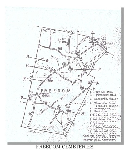
FREEDOM
Contributed by Tom Elliott, whose father transcribed many of the Freedom cemeteries. Info from the tombstone, and/or census, vital records, personal knowledge of Norman R. Elliott. Cemetery inscriptions of Freedom, Maine. Cemetery inscriptions of Freedom, Maine. Copied by Norman Elliott. s.l., Maine Old Cemetery Association, c1971.
Bradstreet Cemetery, "located on farm formerly owned by Herbert Bradstreet, So. Freedom, Maine") (1 Tombstone)
Briggs Cemetery
Commings Cemetery
Glidden - Abbott Cemetery
Gould Cemetery - located in the woods on the road from Freedom village to South Freedom, adjacent to the road that goes to Beaver Hill. (12 Tombstones)
Hutchins Cemetery
Kelley - Danforth Cemetery - located in woods on a woods road adjacent from the old Freedom Town building on the road from Freedom to South Freedom. (12 Tombstones)
Penney Cemetery - located on Mitchell Road.
Pleasant Hill Cemetery - located on Belfast Road, 1/4 mile W of Freedom village (Main cemetery for Freedom)
A - B
C - E
F - H
J - L
M - P
Q - T
U - Z
Smithton Cemetery
Spinney Cemetery
Ranlet - Bowen Cemetery
ISLESBOROUGH
Bay View Cemetery
Dark Harbor Cemetery
Greenwood Cemetery
Maple Grove Cemetery
Pendleton Yard Cemetery
JACKSON
Cates Cemetery
Chase Cemetery
Eastman Cemetery
Grant Cemetery
Jackson Corner Cemetery
Kimball Cemetery
Maplewood Cemetery
Pease Cemetery
Snow Cemetery
Stiles Cemetery
KNOX
Abbott Cemetery
East Knox Cemetery
Knox Ridge Cemetery
Knox Station Cemetery
Leonard/Kelsey Cemetery
Sunnyside Cemetery
LIBERTY
Bolen Hill Cemetery
Boynton Cemetery
Cargill Cemetery
Carter Cemetery
Daggett Cemetery
Fish Cemetery
Glidden Cemetery
Gove Cemetery
Hamilton Cemetery
Hannon/Moody/Brown Cemetery
Hunt Memorial Cemetery
Knowlton Cemetery
M. Cayford Cemetery (located in a pasture)
Nash/Rhodes Farm Cemetery
Sherman's Corner Cemetery
West Liberty Cemetery
Whitten Cemetery
LINCOLNVILLE
Beach (or French) Cemetery
Cross Cemetery
Ducktrap Cemetery
Fletcher/Lovett Cemetery
Lower Cemetery
Maplewood Cemetery
Sylvester Cemetery (Abandoned)
Thomas Cemetery
Union (or Millertown) Cemetery
Upper Cemetery
Youngtown Cemetery
MONROE
Bartlett Yard Cemetery
Goodwin Hill Cemetery
Grout Cemetery
Harmony Place Cemetery
Mansur Cemetery
Monroe Village Cemetery
Mt. Rest Cemetery
Mt. Solitude Cemetery
Pilgrim Home
Robertson Yard Cemetery
MONTVILLE
Allen Cemetery
Averill Cemetery
Carter/Foster Cemetery
Greenwood Cemetery
Halldale Cemetery
Howard Cemetery
Mount Solitude Cemetery
Mt. Repose* Lundberg, Gertrude W. Maine tombstones: Mt. Repose, Montville, Waldo County. Homewood, Illinois, Root and Tree Publications c1972.
North Ridge Cemetery
Pierce Hill Cemetery
Ripley Cemetery
Vose Cemetery
Whitten Cemetery
Whites Corner Cemetery
MORRILL
Cross Cemetery
Cushman Cemetery
Village Cemetery
NORTHPORT
Northport, Waldo Co., Maine cemetery inscriptions with index..
Transcribed by Evelyn A. Cottrell Frost [et al.]; typed for John Cochran
Chapter, D.A.R. Belfast, Maine, The Chapter, c1900, 1987.
Collier Cemetery
East Northport Cemetery
Knight Cemetery
Pitcher Cemetery
Saturday Cove Cemetery
PALERMO
Contributed by Roy Clement
Brown Cemetery - Leaving Hussey's General Store in Windsor, going east to Somerville on Route 105 and at the four corners in village, turn left onto the Turner Ridge Road to Palermo, approx. one mile out take dirt road off to the left, called Colby Rd. or Week's Mill Road, proceed 1-3/4 miles or approx. 1/10 mile beyond the town line of Somerville, left hand side of road, going north, this cemetery has grown up in trees, located in the Woods between old Brown or Brann place and Huck Staples Place. Only 10 marked graves.
Cain Cemetery - Located behind Melvin Higgins' house and in a pasture on road from Sawdust Trail to Hostile Valley.
Center Cemetery - Located on the corner of Nelson Lane and Marden Hill Road.
Colomy Cemetery - Located on discontinued road running north from the Somerville/Deer Hill road; cemetery lies west of Turner Mill Pond.
Dennis Hill Cemetery - Located in field off to right of Nelson Lane from Freedom Road. I have visited. There is a rock formation and cultivated blueberry field, walk along side of field approximately. 1/4 mile, up hill.
Eastman Cemetery - Located on Hibberts' Gore, behind house, old Everett Cunningham Place.
East Palermo Cemetery - Located on north side of Route 3, junction of Banton Road.
Glidden Cemetery - Located on side of road from Walter Banton's to John Tibbetts - E. Palermo.
Greeley Corner, Old and New Sections - Located on Route 3 at Greeley Corner. Separated by a brook.
Hannan Cemetery - Located on road from East Palermo to So. Liberty.
Hisler/Turner Cemetery - Located on former Bill Hisler Farm on discontinued road from Turner Ridge to Sheepscot Lake. This is a private road. Cemetery is located on a knoll to left of this road under a large pine tree (1972)
Lenfest Cemetery - Located on a discontinued road toward Washington from East Palermo - Gore Road.
Marr Cemetery - Located at entrance to John Tibbetts' driveway.
Osgood Cemetery - Located on right about 1/2 mile toward Albion line from Western Ridge, Palermo
Parmeter Cemetery
Perkins Cemetery - Just before Carr's Corners on left, right on road.
Riley Parmenter Cemetery - Located on road from Longfellow Corner to Center of Palermo.
Rust Cemetery - Going from Turner Ridge toward the State Fish Station, watch for gap in the stone wall on the right, into old field, go directly west to far side. Knurled old pine (1972).
Sand Hill Cemetery - Located in the Hostile Valley on the Palermo Town Road or the road connecting the Valley Road and Liberty Road.
Smith Cemetery - Located on Road from No. Palermo to Level Hill.
PROSPECT
Bowdoin Point Cemetery
Burdeen Cemetery
Clark Cemetery
George Cemetery
Harding Cemetery
Maple Grove Cemetery
Prospect/Ferry/Batchelder Cemetery
Silver Cemetery
SEARSMONT
East Searsmont Cemetery
Hillcrest Cemetery
Lassell/Wentworth Cemetery
Lawry/Old Yard Cemetery
Oak Grove Cemetery
Pine Grove Cemetery
SEARSPORT
Bowditch Cemetery - Corner of Main St. and Pendleton Rd.
Elmwood Cemetery
Gordon Cemetery
Mount Hope/Sargent Cemetery
North Searsport (or Evergreen) Cemetery
Sargent Cemetery
Village Cemetery
STOCKTON & SANDY POINT
Contributed by Kitty McLaughlin
Dickey Roberts Cemetery - No stones, Old County Road
Lamphere Cemetery
Mount Recluse Cemetery - Cape Jellison
Mount Prospect Cemetery - Stockton Springs
Otis Harriman Cemetery
Sandy Point Cemetery - Sandy Point
Riverside Cemetery - The Narrows, Route 1, Sandy Point
SWANVILLE
Bailey Farm ("Lost Cemetery") - Follow Route 141 from Belfast to Swanville, Turn left at store, Turn right on Oak Hill Road. Follow road seven or eight miles and cemetery is on the left in the woods. -Private Cemetery
Greenlawn Cemetery - Located in Village on south side of Route 141 (across from church)
Harvey Cemetery - located on Oak Hill Road - immediately after crossing from Belfast. Cemetery on right side of road.
Jeremiah Small Cemetery - Follow directions past Webster/Knowlton Cemetery. Very small cemetery located in woods.
Land of Rest - Follow route 141 from Belfast to Swanville. Turn left at store, turn right on Oak Hill Road. Cemetery located on left by Grange Hall
Nickerson Cemetery - Turn right at Swanville Store, Left on Harriman Rd. Cemetery located on left.
Seekins Cemetery - Follow directions to Harvey Cemetery only continue on Oak Hill Road. Cemetery located on left in the woods. Accessible by woods road.
Tripp Cemetery - Turn right at Swanville Store, Left on Harriman Rd, past Nickerson Cemetery, follow sharpe curve. Cemetery located on left.
Union/Smart Cemetery - Follow Route 141 from Belfast, turn right on Smart Road, Left on Curtis Road. Cemetery on left. (Belfast G. R. 15)
Webster/Knowlton Cemetery - Follow Oak Hill Road towards Swanville, turn left on Roberts Road. Cemetery on left.
THORNDIKE
Blethen Cemetery
Center Yard Cemetery
Coffin Cemetery
East Thorndike Cemetery
Files Hill Cemetery
Friends/Quaker/Cole Cemetery
Hubbard Cemetery
Patterson Cemetery
Sayward Yard Cemetery
Stevens Cemetery - private cemetery
Wing Cemetery
TROY
Contributed by Ralph Hillman
Estes Cemetery - A small family cemetery in the woods east of Barker Road and south of North Dixmont Road. Very difficult to locate.
Fairview Cemetery
Hathaway Cemetery - Established in the 1840s. On Ward Hill Road about 1-1/4 miles north of Roger's Corner and the North Dixmont Road. Cemetery on the east side of the road. Generally well kept.
Jewell Cemetery - Actually located in Dixmont about on the Troy/Dixmont line. Many Troy families buried here. About 0.9 miles south from US202/St Rte 9 on Jewell Road. Jewell Road leaves US202 just over the Troy Town Line into Dixmont.
Mt. Holly Cemetery - Established in 1836. Many of the earliest settlers are buried here. Many stones damaged or missing. On the north side of US202/St Rte 9 just east of Troy Corner and across from Troy Union Church.
Rogers Cemetery - (formerly "Fairview") established in 1837. The largest cemetery in Troy. North from Hales Corner on Rogers Road about 1/2 mile from US202/St Rte 9. On the east side of the road. Well kept.
Webb Cemetery - Established in the 1840s. From US202/St Rte 9 at Green's Corner where St Rte 220 goes north, go south on Myrick Road about 1.7 miles to Gerrish Corner. Turn east on Whitaker Road (the old Penobscot Road) about 0.9 miles. This is a small cemetery away from the north side of the road and on the north side of a small stream.
Webster Cemetery - Established in the 1840s. South from Troy Corner on Bagley Hill Road about 1-1/4 miles. Turn east on the Webster Cemetery Road (continuation of Whitaker Road and the old original Penobscot Road) for about 1.4 miles on the dirt road. Cemetery on the south side of the road.
Whitten Cemetery - A small family cemetery about 0.4 miles north of the North Dixmont Road on a dirt track. The dirt track is about 0.3 miles west of the Dixmont Town Line.
Ralph Hillman's Note: There are quite likely one or two other small family cemeteries that have been lost from memory. If anyone finds these locations I would like to know. A Barker Cemetery is quite likely east of Barker Road in the woods about at the junction of Bishop Road. A Bennett Cemetery was somewhere along the east shore of Unity Pond west of Smart's Corner. [Check] DeLorme's The Maine Atlas and Gazetteer for names of roads and locations. I have data from most of these cemeteries if people wish to contact me.
UNITY
Boulter Cemetery - North Side of Hunter Road at the intersection of Bryant and Ayer Ridge Road
Douglass Cemetery - West side of Stevens Road prior to crossing town line of Freedom
Farwell Cemetery - On the left of Berry Road after crossing Sandy Stream from Crosby Brook Road
Fowler Cemetery - West side of State Route (s) 9/202 3/10ths of a mile from Albion Town Line
Pond Cemetery - On both sides of Kanokolus Road, west of State Routes 9 and 202
Village Cemetery - On south side of School Street (Route 139); west of village
WALDO
Contributed 31 Mar 2000 by Debbie Sue Berry
Evans Corner/Ellis Cemetery - located on Route 7, second cemetery on right as you take Route 7 from Belfast to Brooks
Hadley Cemetery - located on Route 7, first cemetery on right as you leave Belfast for Brooks
Harding/Roberts Cemetery - located on Route 131 - take Route 7 to junction of Route 131 and turn right - cemetery on right
Littlefield Cemetery - Waldo Station, Route 7 to junction of Route 131, turn right on Route 131, turn left at first 4-way, cemetery is the next left [Cemetery is off the road and hard to see from the road]
Paul Cemetery - located on Birches Road, off Route 137, second cemetery on right
Piper/Durham Cemetery
Shorey Cemetery - located on Birches Road, off Route 137, first cemetery on right
Walls/Bartlett Cemetery
WINTERPORT
Bald Hill Cove Cemetery
Gravestone inscriptions in cemetery at Bald Hill Cove, Winterport, Maine. Copied by Myra E. Sullivan. Bangor, Maine. ME. Sullivan, c19--? Use same directions as above about 3 miles from the village on your right is the cemetery.
Brown/Hurd Cemetery - From Winterport Village, take the Back Winterport road about 2 miles you will come to a 4 corners take a right onto the "Bald Hill Cove road about a mile down that rd on your right in the woods is a cemetery with only 2 stones.
Chase Monument Cemetery - From Winterport village go out Rte.69 about 4 miles you will come to Ellingswood Corner, take a left onto the Monroe road go about 2 1/2 miles on your right will be the Thornton Patterson house, beside the house is a lane going up thru a field in the corner of the field is the cemetery.
Clark Cemetery - From Winterport village proceed out Rte.69 until you come to the Rte.139 turnoff on your left about 2 miles from the village. Travel out Rte139 about 2miles on your right will be the Goshen rd. on your left will be Deb's Market, go out the Goshen rd 3/4mile on your right will be the Clark rd. turn onto it and the cemetery is on your left.
Clements Cemetery - Use the above directions go down the Monroe road about 4 miles on you right by the Vandestine home in the woods is the cemetery.
Cole Cemetery - From Winterport village go out the Back Winterport Road about 2 miles at the intersection take your left onto the Meadow road about a 1/2/mile on your right is the cemetery.
Coffin Cemetery - Use the same directions as above but only go about a mile on your right up in the field sets the cemetery behind the Littlefield home.
Ellingwood Corner Cemetery
Ellingwood Corner Cemetery, Winterport, Maine. Gardiner, Maine, M. McDonald, c1988. Use the same directions as above when you get to Ellingwood Corner go thru the Intersection and just on your right is the cemetery.
Grant/Littlefield Cemetery - Use the same directions as above go out the Goshen rd 1mile as you pass the Clark farm the cemetery will be at the top of the hill on your left.
Kempton Cemetery
Oak Hill Cemetery - From the center of the village going north on Rte.1 take a left and start out the Lebanon Road at the top of the hill by the ballpark on your right is the "Oak Hill Cemetery".
Perkins Cemetery
Stubbs Cemetery
Twining Cemetery - Use same directions as above but travel about 3 miles just after you cross the R.R. tracks on your left is the Twining Rd go up the rd 1/2 mile on the right.
Winterport Cemetery [2] - From the village go north on Rte.1 2miles on your right will be the Lower Oak Pt. Rd down this road are 2 Cemeteries-- the Kempton which will be by the river and the Stubbs Cemetery both of these are summertime visits.
Woodman Cemetery - Use the same directions as above go about 1/4 mile on your right there sets 1 stone just back in the woods.


