

Ottawa County
KSGenWeb

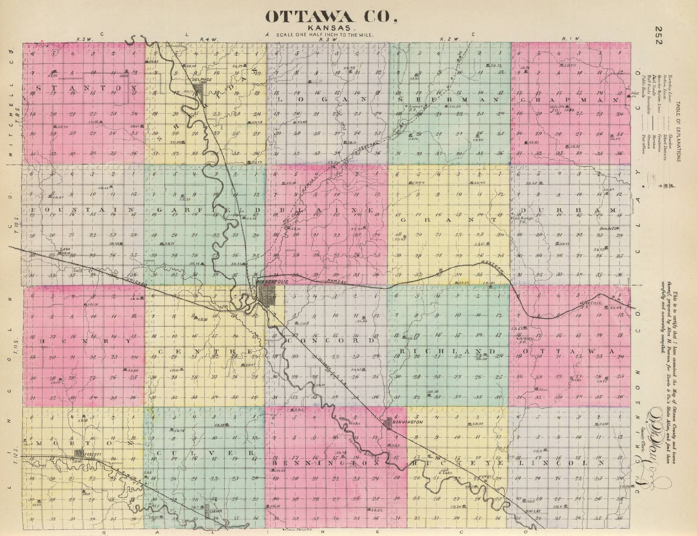
1887 Ottawa County
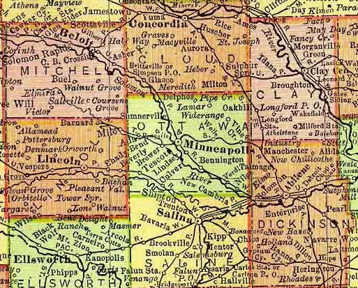
1895 Rand McNally Atlas
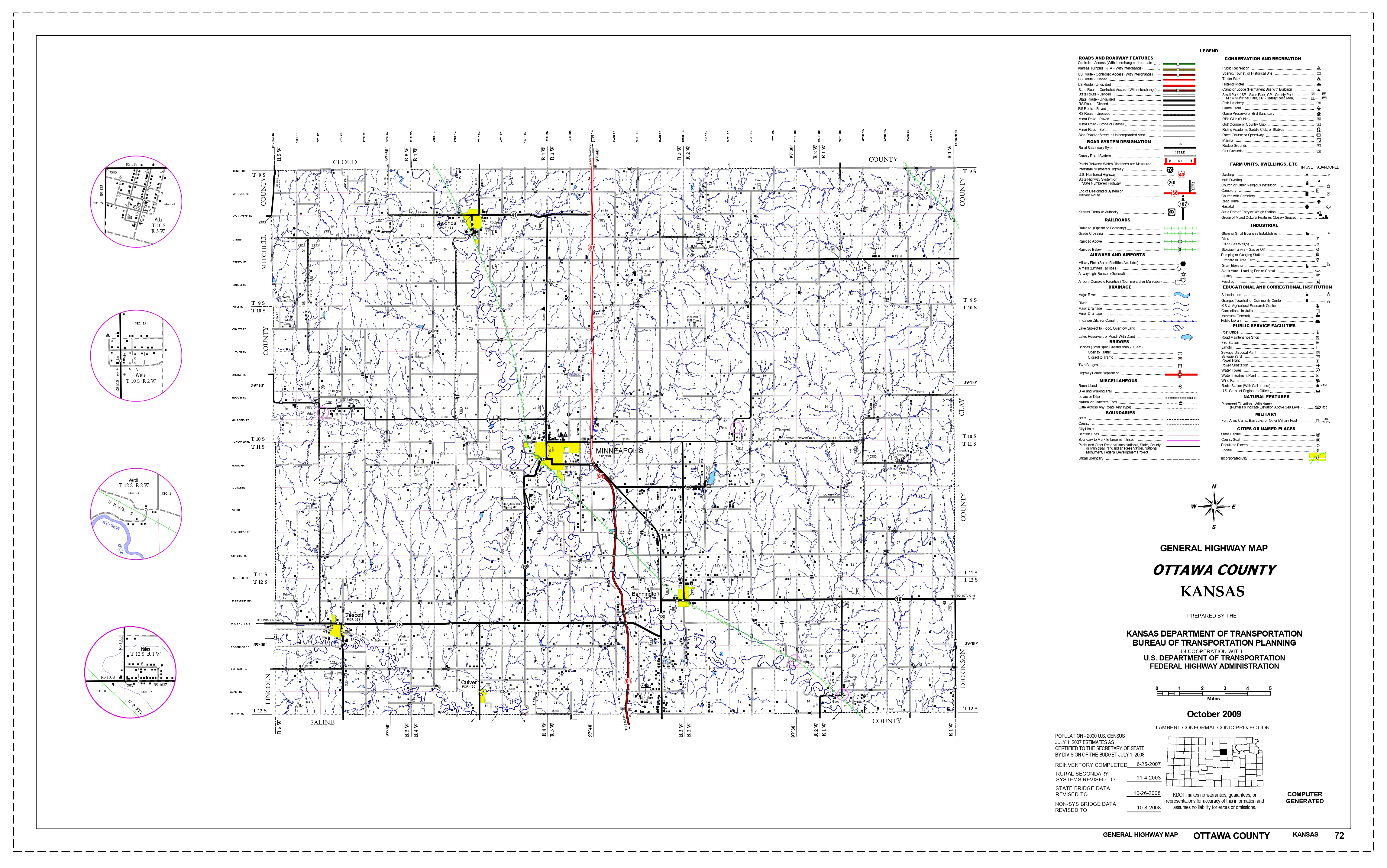
2009 Kansas Dept. of Transportation
Ada, a village of Ottawa county, is located on the Atchison, Topeka & Santa Fe R. R., and on Salt creek in Fountain township, 10 miles west of Minneapolis, the county seat. It has banking facilities, all lines of business activity, telegraph and express offices and a money order postoffice with one rural mail route. It is the shipping point of a prosperous farming community. The population in 1910 was 300. Extracted 2002 by Carolyn Ward from Kansas: A Cyclopedia of State History, volume I, page 25.
Bennington, one of the incorporated towns of Ottawa county, is located on the Union Pacific R. R. and on the Solomon river, in Bennington township, 9 miles southeast of Minneapolis, the county seat. It has two banks, an opera house, two grain elevators, flour mill and a weekly newspaper, as well as all the main lines of business. There are telegraph and express offices, and a money order postoffice with two rural routes. The population in 1910 was 386. The community was settled in 1870 and a store opened in 1873 by George Parker. When the railroad was built in 1878 the town was laid out. The promoters were Daniel Struble and C. Nelson. An iron bridge was built over the Solomon at a cost of $4,500; Markley Bros. put up a flour and saw mill run by water power at a cost of $20,000, and in 1880 a $2,000 school house was built. Extracted 2002 by Carolyn Ward from Kansas: A Cyclopedia of State History, volume I, pages 174-175.
Culver, an incorporated town of Ottawa county, is located in Culver township, on the Union Pacific R. R. and the Saline river, about 10 miles southwest of Minneapolis, the county seat. It has a bank, telegraph and express offices, and a money order postoffice with 2 rural routes. All lines of business activity and the leading denominations of churches are represented. The population in 1910 was 326. Extracted 2002 by Carolyn Ward from Kansas: A Cyclopedia of State History, volume I, page 486.
Delphos, the second largest town of Ottawa county, is located on the Solomon river and on the Union Pacific R. R., in Sheridan township, about 12 miles northwest of Minneapolis, the county seat. It has a public library, an opera house, 2 banks, a weekly newspaper (the Republican), telegraph and express offices and an international postoffice with four rural routes. It is an important receiving and shipping point, having two flour mills and a creamery and facilities for handling large quantities of grain. It is an incorporated city of the third class and the population in 1810 was 767. The promoter of the town, W. A. Keizer, platted it in 1870. A postoffice had been established two years before with Levi Yockey as postmaster. The first store was opened by Simpson, Seymour & Easley. In 1872 a bridge was built over the Solomon, $5,000 n bonds being voted for the purpose. Delphos was from the first a grain market and elevators were built before the railroads came through in 1878. In 1879 half of the town was destroyed by a tornado. The first newspaper was started that year, the "Delphos Herald." The first bank was established in 1880. Delphos is famous as the yearly camping ground of the society of spiritualists, which was organized in 1877 at that place with thirteen members. This camp meeting brings hundreds of people to Delphos every summer. Extracted 2002 by Carolyn Ward from Kansas: A Cyclopedia of State History, volume I, page 507.
Lindsey, a station on the Union Pacific R. R. in Ottawa county, is located in Concord township, 2 miles southeast of Minneapolis, the county seat. It has express and telegraph offices, a money order postoffice, and is a shipping point for agricultural products and stock. The population in 1910 was 28. Extracted 2002 by Carolyn Ward from Kansas: A Cyclopedia of State History, volume II, page 165.
Minneapolis (county seat), the judicial seat of Ottawa county, is located a little to the west of the center of the county on the Solomon river and at the junction of the Union Pacific and the Atchison, Topeka & Santa Fe railroads. The Solomon river furnishes water power for manufacturing purposes. There are machine shops, flour mills, grain elevators, a foundry, alfalfa mills, a creamery, an ice plant, an electric light plant, waterworks, an opera house, public library, 2 weekly and 3 monthly newspapers and 3 banks. There are telegraph and express offices and an international money order postoffice with 7 rural routes. The main products shipped are wool, live stock, poultry and produce. The city has fine church and public school buildings, and in 1910 reported a population of 1,895. Minneapolis was laid out in 1866 by Israel Markley, Elijah Smith, Dr. James McHenry, A. C. Stull and A. J. Smith. It was first called "Markley Mills," because Mr. Markley built a grist mill at that point in 1866. In that same year the county seat was brought there from Ayersburg by vote of the people. At the same time Col. John Kerwin moved his store from Fort Solomon. The town was incorporated as a city of the third class in 1870. The first hotel was opened in 1870 and the first bank established in 1875. The railroad was built in 1878. Extracted 2002 by Carolyn Ward from Kansas: A Cyclopedia of State History, volume II, page 289.
Niles, one of the thriving litttle[sic] towns of Ottawa county, is located on the Union Pacific R. R. in Lincoln township near the county line, 18 miles southeast of Minneapolis, the county seat. It has a bank, telegraph and express offices, and a money order postoffice with one rural route. All the main lines of business activity are represented. The population in 1910 was 200. Extracted 2002 by Carolyn Ward from Kansas: A Cyclopedia of State History, volume II, page 370.
Sumnerville
Tescott, the third largest incorporated town of Ottawa county, is located in Morton township on the Salina river and the Union Pacific R. R., 18 miles southwest of Minneapolis, the county seat. It has a bank, a flour mill, telegraph and express offices, and a money order postoffice with two rural routes. The population in 1910 was 421. Extracted 2002 by Carolyn Ward from Kansas: A Cyclopedia of State History, volume II, page 803.
Verdi, a station on the Union Pacific R. R., in Ottawa county, is located in Buckeye township, 15 miles southeast of Minneapolis, the county seat. It has an express office and a money order postoffice. The population in 1910 was 65. Extracted 2002 by Carolyn Ward from Kansas: A Cyclopedia of State History, volume II, page 843.
Vine, a village on the Atchison, Topeka & Santa Fe R. R., in Ottawa county, is 18 miles east of Minneapolis, the county seat. It has a money order postoffice and telegraph and express office. The population in 1910 was 50. The railroad name is Vine Creek. Extracted 2002 by Carolyn Ward from Kansas: A Cyclopedia of State History, volume II, page 848.
Wells, a station on the Atchison, Topeka & Santa Fe R. R. in Ottawa county, is located in Grant township, 9 miles east of Minneapolis, the county seat. It has a money order postoffice with one rural route and an express office. The population in 1910 was 42. Extracted 2002 by Carolyn Ward from Kansas: A Cyclopedia of State History, volume II, pages 899-900.
Copyright © 1996 - The USGenWeb® Project, KSGenWeb, Ottawa County
Design by Templates in Time
This page was last updated 04/01/2024