

Montgomery County
KSGenWeb

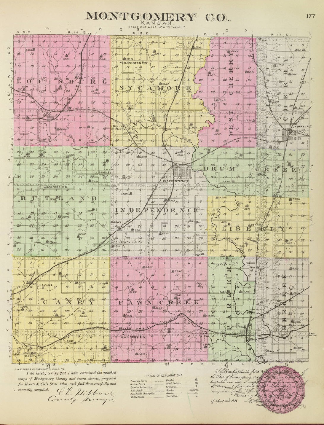
1887 Montgomery County

1887 Havana, Independence, and Coffeyville

1895 Rand McNally Atlas

2010 Kansas Dept. of Transportation

| 1. All Saints, E3 | 2. Bethel, D2 | 3.Black Jack, B4 | 4. Brock, A2 | 5. Calvary (Coffeyville), D4 |
| 6. Calvary (Independence), D2 | 7. Centennial, E2 | 8. Choteau. D1 | 9. Elmwood, D4 | 10. Evangelical Lutheran Immanuel, B4 |
| 11. Fairview (Cherryvale), E2 | 12. Fairveiw (Coffeyville), D4 | 13. Farm Ridge, C1 | 14. Fawn Creek, B4 | 15. Harding, C4 |
| 16. Harmony, E2 | 17. Harrisonville, C3 | 18. Havana, A3 | 19. Highland Center, B2 | 20. Hilts, E1 |
| 21. Irish Creek, D2 | 22. Jefferson, C3 | 23. Josaphat (Catholic), D4 | 24. Kalloch, E4 | 25. Krone, C1 |
| 26. Le Hunt,C2 | 27. Liberty, D3 | 28. McClure-Gorham, A4 | 29. Mt. Hope, D3 | 30. Oak Hill, B2 |
| 31. Parker, B2 | 32. Pleasantdale, E1 | 33. Pratt, D2 | 34. Pumpkin Creek, E4 | 35. Quaker, B2 |
| 36. Radical, C2 | 37. Restlawn Memorial Park, D4 | 38. Robbins, C4 | 39. Rutland, B3 | 40. St. Francis Xavier, E2 |
| 41. Simpson, C1 | 42. Spring Hill, D3 | 43. Sunnyside, A4 | 44. Union, E4 | 45. Westrailia, E4 |
| 46. White, B1 | 47. Woodring, B2 | 48. Zion Lutheran, D2 | 49. Carson, A2 |
Avian
Blake
Bolton, a village of Montgomery county, is a station on the line of the Atchison, Topeka & Santa Fe R. R. that runs from Independence to Tulsa, 8 miles southwest of Independence. It is a money order postoffice, is suppiled[sic] with telegraph, telephone and express service, and is a shipping and supply point for that section of the county. The population in 1910 was 75. Extracted 2002 by Carolyn Ward from Kansas: A Cyclopedia of State History, volume I, page 203.
Caney, one of the four important
towns of Montgomery county, is located near the Oklahoma line at the junction of
the Missouri Pacific and the Missouri, Kansas & Texas R. R., 20 miles southwest
of Independence, the county seat. It is in the gas belt and has grown very
rapidly, especially in the past ten years, during which time it has trebled its
population. It has a good system of waterworks and an efficient fire department.
The combined output of the gas wells in the vicinity is 175,000,000 cubic feet
per day. The largest oil tank farm in the state is located near here. It covers
800 acres. The manufacturing interests in Caney include 2 large glass factories,
a brick and tile works, a large zinc smelter and an oil refinery. There are 2
banks, an ice and cold storage plant, 3 public school buildings, a public
library, 2 weekly newspapers (the Chronicle and the News), telegraph and express
offices and an international money order postoffice with one rural route. The
town was incorporated in 1905. About this time it received extensive advertising
throughout the whole nation on account of a gas well which took fire and burned
furiously for several months. Tourists, many of whom were from distant states,
flooded the town to view the immense flames, the roaring of which could be heard
for miles. According to the census of 1910 the population of Caney was 3,597.
The first store in Caney was opened by Dr. J. W. Bell in 1869. A genera!
merchandise store was established by O. M. Smith in 1870. A mail route was
established in that year which enabled the settlers to get their mail regularly.
The town was laid out and a number of business enterprises started. The first
newspaper (the Caney Chronicle) was started in 1885. Caney was organized and
incorporated as a city of the third class in 1887. The first officers were:
Mayor, P. S. Hollingsworth; police judge, F. H. Hooker; clerk, F. H. Dye;
councilmen, William Rodgers, Harry Wiltse, J. J. Hemphill, J. A. Summer and W.
B. Williams. The first railroad reached Caney about 1887.
Extracted 2002 by Carolyn Ward from Kansas: A Cyclopedia of State History,
volume I, pages 278-279.
Cherryvale, one of the four important towns of Montgomery
county, is located near the east line, 12 miles northeast of Independence, the
county seat. It is a railroad center, being the point where the main line of the
Atchison, Topeka & Santa Fe R. R. diverges, one line running south and the other
southwest, and where the St. Louis & San Francisco diverges both lines running
eastward. Cherryvale is a manufacturing town. It has a large zinc smelter which
handles most of the zinc that comes from the world famous Joplin-Galena
district, 6 brick and tile plants, iron works, glass plant, implement factory,
oil refinery, foundry, machine shops, shovel factory, grain elevators, flour
mills, planing mills, creamery, ice and cold storage plant, etc. The city also
has 2 daily and weekly newspapers (the Republican and the Journal), a well
equipped fire department, an electric light and power plant, churches, lodges
and schools, and good banking facilities. Cherryvale is connected with
Independence and with Coffeyville by an electric interurban railway. It is
supplied with telegraph and express offices and has an international money order
postoffice with 6 rural routes. The population in 1910 was 4,304.
The
town was laid out in 1871 by the Kansas City, Lawrence & Southern Kansas Railway
company. The first building was the Grand Hotel erected by a Mr. Darr. The first
store was opened by C. A. Clotfelter and J. P. Baldwin. A number of business
enterprises had been established by 1873, when the town was swept by fire. The
buildings were later replaced by brick structures, but the growth of the town
was slow until 1879, when a large increase in the railroad mileage in this
section of the country opened up the avenue of trade. The first church
organization was effected in 1871 and the first school was taught in 1873 by
Miss Mary Greenfield.
Cherryvale was incorporated as a city of the third
class in 1880. The first election was held in April of that year and the
following officers chosen; mayor, C. C. Kincaid; police judge, A. Wood;
councilmen, A. Buch, J. M. Richardson, Frank Bellchamber, J. A. Handley and A.
V. McCormick. At the first meeting of the council, the following officers were
appointed: treasurer, A. Palp; clerk, M. F. Wood; marshal, J. C. Cunningham;
street commissioner, B. F. Hinds.
In 1889 bonds to the amount of $5,000
were voted for use in prospecting for coal. Gas was found instead of coal and
later oil was discovered. There are at present 31 gas wells in the vicinity from
which the total output is 160,000,000 cubic feet of gas per day, the largest
well producing 11,000,000 cubic feet. It is said to be the largest gas well in
the state. Cherryvale has a live commercial club, which is doing a great deal to
promote the general prosperity of the town.
Extracted 2002 by Carolyn Ward from Kansas: A Cyclopedia of State History,
volume I, pages 322-323.
Coffeyville, the largest city in Montgomery county and one of the
important cities of southeastern Kansas, is located on the Verdigris river near
the Oklahoma state line, 15 miles southeast of Independence, the county seat.
Four railroads converge at this point—the Atchison, Topeka & Santa Fe, the
Missouri, Kansas & Texas, the Missouri Pacific, and the St. Louis & San
Francisco. It is located in the natural gas fields, the wells in the vicinity
yielding about 1,000,000,000 cubic feet of gas per day. This is furnished to the
factories for three cents per 1,000 feet, which has resulted in building up
extensive manufacturing interests among which are, 9 glass factories, 6 brick
plants, an oil refinery, 4 foundries, a plow factory, 2 box factories, 2 planing
mills, carriage and wagon factory, paper factory, zinc smelter, pottery works,
excelsior factory, plaster factory, roof tile works, wire fence factory, egg
case factory, novelty works, and implement works. Other manufacturing plants are
under process of construction. The Missouri Pacific railroad shops are located
here.
The town is advanced in the matter of public improvements, having a
sewer system, waterworks, fire department, police department, 9 public school
buildings, street railway, public parks and electric lights. There are 5 banks,
4 theaters, a hospital, 3 daily and 3 weekly newspapers, 4 flour mills, grain
elevators, several wholesale jobbing houses, 2 ice plants, a packing house and
all lines of retail trade. Coffeyville is also an important grain market and a
shipping point for all kinds of farm produce. It is connected with Cherryvale
and Independence by means of interurban electric lines. The town is supplied
with telegraph and express offices and has an international money order
postoffice with 4 rural routes. The population according to the census of 1910
was 12,687, which is nearly treble the population of 1900.
Coffeyville
was founded in the fall of 1869, by Col. Coffey, N. B. Blanton, Edward Pagan,
John Clarkson and William Wilson. This town was later absorbed by another of the
same name located a mile north and promoted by the railroad company in 1871, as
the terminus of the first railroad built in the county. The towns of Westralia,
Parker, Verdigris City and Claymore were all eventually absorbed by Coffeyville.
The postoffice was established in 1871 at the original town, and Col. Coffey was
made postmaster. The next year it was moved to the new town. Coffeyville was
organized and incorporated as a city of the third class in 1872, with the
following officers: Mayor, A. B. Clark; clerk, I. N. Neeld; treasurer, T. B.
Eldridge; police judge, G. A. Dunlap; marshal, Peter Flynn; councilmen, G. J.
Tallman, David Blair, C. W. Curry, W. H. Bowers and E. S. Eldridge. The first
school was taught in a store building on the old town site in 1871 by J. T.
Creswell. The Coffeyville journal was established in 1875 by W. A. Peffer. The
first banking house was opened in May, 1880, by Ayres & Steel. A board of trade
was organized in 1884, and on July 20, 1887, Coffeyville was incorporated as a
city of the second class by proclamation of Gov. Martin.
In 1888 an
incident occurred in Coffeyville which startled the whole state and led to an
investigation by the state officials. A package directed to Winfield was left at
the express office on Oct. 18. While still in custody of the express agent it
exploded and killed Mrs. Upham and her daughter, Mabel. It was a package of
dynamite and a political murder was intended by the party who prepared it.
In 1892 occurred the famous Dalton raid at Coffeyville. The Daltons with two
accomplices, comprising a band of five, came into the town with the intention to
rob the banks and commit as many murders as necessary in the process. While
robbing the bank of Condon & Co., the ruffians were attacked by the citizens and
one of them wounded so that he could not shoot. Undismayed by the rain of
bullets, they took all the currency, amounting to $11,000, and went to the First
National bank, where they secured $20,000 and went out into the alley, by which
they expected to escape. Here they were fired upon by the citizens and a battle
began, which lasted 12 minutes. When it was over four of the robbers were dead
and one seriously wounded. Out of the ten citizens who took part 4 were killed
and 2 wounded. The wounded robber was Emmet Dalton, who was at that time 16
years of age. He never fully recovered from his wounds. After serving a number
of years in the state penitentiary he was released in 1909.
Extracted 2002 by Carolyn Ward from Kansas: A Cyclopedia of State History,
volume I, pages 387-388.
Corbin, a town of Falls township, Sumner county, is 13 miles south west of Wellington, the county seat, and is a station on the Chicago, Rock Island & Pacific, and the Atchison, Topeka & Santa Fe railways. It has a money order postoffice with one rural route, express and telegraph offices, telephone connections, a hotel, a good local trade, Protestant churches, and in 1910 reported a population of 174. Extracted 2002 by Carolyn Ward from Kansas: A Cyclopedia of State History, volume I, page 445.
Dearing, a little town of Montgomery county, is located on Onion creek 12 miles south of Independence, the county seat, at the junction of two lines of the Missouri Pacific R. R. It has a bank, and all the main lines of mercantile enterprise. A large smelter is in operation handling ore which is mined in the vicinity. The town was incorporated in 1909, and the population according to the census of 1910 was 250. Dearing is supplied with telegraph and express offices and an international money order postoffice. Extracted 2002 by Carolyn Ward from Kansas: A Cyclopedia of State History, volume I, page 498.
Elk City, an incorporated town of Montgomery county, is a station on the
Missouri Pacific and on the Atchison, Topeka & Santa Fe railroads, 13 miles
northwest of Independence. It has natural gas for heating, lighting and
commercial purposes. There is a brick and tile manufacturing works, a flour
mill, a weekly newspaper, one state and one national bank. The town is supplied
with express and telegraph offices and has an international money order
postoffice with 6 rural routes. The population according to the 1910 census was
659.
Elk City is the oldest town in Montgomery county, being an outgrowth
of the trading post established at that point by John Kappel in 1868. A town
company was formed the same year and the site located. A. E. Baird put in a
stock of general merchandise and in 1870 M. D. Wright, who had brought a stock
of notions with him in his prairie schooner opened the third store. A. R. Quigg
started a hardware store. The first saw mill was built in 1869 by S. B. Davis,
T. J. Brown and Samuel Maples. The first blacksmith shop was built by J. P.
Morgan. The first death as well as the first birth was in the Hammond family. In
April, 1869, a son was born to Thomas and Bertha Hammond. The child was killed
by accident the same month. Thomas Hammond was shot and killed by a man by the
name of Morrison in a quarrel over a plow.
In 1870 the Elk City
postoffice was established with William H. H. Southard as postmaster. The next
year the town was incorporated as a city of the third class. The first election
resulted in the choice of the following officers: Mayor, Herbert Prentis; police
judge, James Smith; councilmen, Uri Coy, J. Baldwin, William H. H. Southard, W.
W. Woodring and A. R. Quigg.
The first school was taught in a log school
house by William Osborne in 1869. The first bank was established by E. E. Turner
in 1881. Prior to 1882 three attempts had been made to establish newspapers. A
brick yard and a flour mill had been put in operation.
In 1902 a company
was organized to prospect for gas, which was found after several failures.
Several companies are now operating in the vicinity and a number of fine oil
wells, as well as gas wells are producing.
Extracted 2002 by Carolyn Ward from Kansas: A Cyclopedia of State History,
volume I, pages 572-573.
Havana, one of the smaller towns of Montgomery county, is a station on the Atchison, Topeka & Santa Fe R. R. 16 miles southwest of Independence, the county seat. It is the trading center for a large territory devoted to agriculture and stock raising. It has a bank, telegraph and express offices and a money order postoffice with two rural routes. The town was founded in 1869 when Callow & Myers opened the first general store. It was incorporated as a city of the third class in 1910, and the population according to the census of that year was 227. Extracted 2002 by Carolyn Ward from Kansas: A Cyclopedia of State History, volume I, page 830.
Independence (county seat), one of the
important cities of southeastern Kansas, and from a manufacturing standpoint,
one of the most important in the state, is located in the central part of
Montgomery county, of which it is the judicial seat. It is on the Verdigris
river in the midst of the great natural gas and oil fields, and the gas, which
is furnished for commercial purposes for 3 cents per 1,000 feet, has been a
great factor in developing the local mineral deposits. Coal, limestone, cement
stone, clay shale and sand for glass are found in considerable quantities in the
immediate vicinity. The manufacturing establishments include a rubber factory, 3
glass factories, 2 ice factories, 2 iron plants, vitrified brick plant, paper
mill, cracker factory, cotton twine factory, shirt factory, machine shops,
foundries, candy factory, several oil refineries, extensive cement works and an
electric light plant. The city is one of the best equipped in the state so far
as public improvements are concerned. It has a good system of waterworks, a
$50,000 opera house, more miles of paved streets than any other city in the gas
belt, a fine sewerage and drainage system, a $25,000 Carnegie library, and an
auditorium seating 3,000 people. It claims to have the best band and the finest
high school building in the state. All the business houses are of brick and
stone with plate glass fronts, and some of the finest lodge buildings in the
state are located here. There are 4 banks, 2 daily and 2 weekly newspapers,
flour mills and elevators. A hospital and nurses training school is maintained
in a building erected for the purpose at an expense of $20,000. Independence is
connected with Cherryvale and Coffeyville by interurban electric railway. It is
supplied with telegraph and express offices, and has an international money
order postoffice with seven rural routes. The population, according to the
census of 1910, was 10,480.
The site of Independence was bought from the
Indians by George A. Brown in Sept., 1869, before the land had been acquired by
the government. The town was promoted by Oswego men, and a paper was started in
Oswego called the "Independence Pioneer," through which the new town was
extensively advertised. In October the first colony, consisting of 18 families
from Indiana, settled on the town site. They built temporary huts of prairie
hay, and it is said that no less than 40 hay huts stood on the Independence town
site that winter. The next spring building began. The town company erected a
hotel called the Judson House. The first store was opened in Oct., 1869, by E.
E. Wilson and F. D. Irwin. In May, 1870, Independence became the county seat,
and in July the postoffice was established. A government land office was
established there in 1872. In January of that year the branch railway called
"Bunker's Plug" was completed. At this time over 200 houses had been built, the
population numbered 2,300, mills had been put up and other business enterprises
established. Independence now became a city of the second class, having been
first organized as a village in July, 1870, and made a city of the third class
in November of that year. The trustees of the village were: J. H. Pugh, J. E.
DonLavy, E. E. Wilson, R. F. Hall and O. P. Smart. The first officers elected
after the incorporation as a city of the third class were: Mayor, J. B. Craig;
clerk, C. M. Ralstine; treasurer, J. E. DonLavy; councilmen, Thomas Stevenson,
A. Waldtschmidt, W. T. Bishop, G. H. Brodie and F. D. Irwin. Independence was
made a city of the second class March 20, 1872.
The first school was
taught by Miss Mary Walker in 1870. The first religious services were held in
the hay-shed residence of Mrs. McClurg in 1869. The south Kansas Tribune, which
is still published, was the first newspaper and was established in 1871 by L. U.
Humphrey & W. T. Yoe. The first banking house, known as Hull's Banking company,
was established in Dec., 1871. It was the only one that continued in business
during the subsequent hard years. In 1881 a company was organized to mine coal.
The discovery of gas and oil followed.
Extracted 2002 by Carolyn Ward from Kansas: A Cyclopedia of State History,
volume I, pages 898-899.
Jefferson, one of the villages of Montgomery county, is located on Fawn creek 8 miles south of Independence, the county seat, and is a station on the Missouri Pacific R. R. It has an express office, a good local trade, and a money order postoffice with one rural route. The population, according to the census of 1910, was 100. Extracted 2002 by Carolyn Ward from Kansas: A Cyclopedia of State History, volume I, page 22.
Le Hunt (historical)
Liberty, the former county seat of Montgomery county, is located in Liberty township on the Atchison, Topeka & Santa Fe R. R., 10 miles east of Independence, the county seat. It has a bank and a weekly newspaper (the Liberty Sentinel). It is an incorporated city of 385 inhabitants, according to the census of 1910, has telegraph and express offices and a money order postoffice with three rural routes. Liberty was established by the citizens of the towns of Verdigris and Montgomery in 1869, the original site being 6 miles south of Independence. It was made the county seat in the same year, but retained the honors only a few months. When the railroad was built in 1870, the town was removed several miles to its present site. One of the early important industries was the flour mill of John McTaggart, which was built in 1875 at a cost of $14,000, and had a cotton gin in connection with it. Extracted 2002 by Carolyn Ward from Kansas: A Cyclopedia of State History, volume II, page 152.
Sycamore, one of the villages of Montgomery county, is a station on the Missouri Pacific R. R. in Sycamore township 7 miles north of Independence, the county seat. It has telegraph and express offices, a money order postoffice with one rural route, a good local trade, and does some shipping. The population, according to the census of 1910, was 175. Extracted 2002 by Carolyn Ward from Kansas: A Cyclopedia of State History, volume II, page 793.
Tyro, a town of Montgomery county, is located in Caney township on the Missouri Pacific R. R., 26 miles south of Independence, the county seat. It is a thriving little city having more than doubled in population in the last ten years. It was incorporated as a city of the third class in 1906. It is located in the gas fields; a shipping point for grain, live stock and farm produce; has a bank and a large local trade; is supplied with express and telegraph offices, and has a money order postoffice with one rural route. The population according to the census of 1910 was 603. Extracted 2002 by Carolyn Ward from Kansas: A Cyclopedia of State History, volume II, page 823.
Videtta Spur
Wayside, a hamlet of Montgomery county, is a station on the Atchison, Topeka & Santa Fe R. R. in Caney township, 11 miles southwest of Independence, the county's seat. It has an express office and a money order postoffice with one rural route. The population according to the census of 1910 was 40. Extracted 2002 by Carolyn Ward from Kansas: A Cyclopedia of State History, volume II, page 897.
Copyright © 1996 - The USGenWeb® Project, KSGenWeb, Montgomery County
Design by Templates in Time
This page was last updated 03/31/2024