

Washington D.C.
DCGenWeb

Genealogical materials often make reference to the old street names, particularly city directories. This can cause confusion. For example, my ggg grandparents were married at the "Congress Street Protestant Methodist Church" on what is now 31st St., now called the Dumbarton United Methodist Church. --Contributor unknown

Ellicott's 1792 revision of L'Enfant's plan

War of 1812
Road to Washington

1888 Streetcar Map

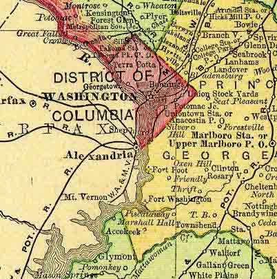
1894 Map of DC Alexandria
Courtesy of the University of Texas Libraries
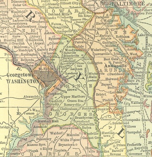
1895 Rand McNally Atlas
1914 Atlas
Anacostia - Population 1,027; Post Office; Railroad Station; Express Office
Benhing's - Population 267; Post Office; Railroad Station; Express Office
Benning - Post Office
Brightwood - Population 153; Post Office
Brookland - Population 86; Post Office
Brooks - Post Office
East Capitol - Post Office
Garfield - Population 123; Post Office
Georgetown - Population 12,578; Post Office
Ivy City - Post Office
Metropolitan Junction - Railroad Station; Express Office
Navy Yard - Railroad Station
Potomac Junction - Railroad Station
Shepherd - Railroad Station; Express Office
Silver Springs - Railroad Station; Express Office
South Washington - Post Office
Tacoma Park - Population 189; Post Office
Takoma - Railroad Station
Tenallytown - Population 278; Post Office
Terra Cotta - Population 57; Post Office; Railroad Station; Express Office
Union Stock Yards - Railroad Station
Uniontown - Railroad Station; Express Office
University Station - Railroad Station
WASHINGTON - Population 230,392; Post Office; Railroad Station; Express Office
Winthrop Heights - Population 23; Post Office
Moreover, the character of public assistance extended to needy families depended in considerable part upon where they lived. For the method the city early adopted in distributing funds for poor relief, policing, and other public purposes penalized the poorer parts of the city. Each ward collected its own taxes, paid a small part into the city treasury and spent the rest within its own limits; each ward independently solicited contributions for relief of its own poverty-stricken inhabitants.
After 1820 when a rearrangement made six wards out of the original four, the second and third wards were the wealthiest, and, because they could afford expensive improvements, the area above southwest E Street stretching from the Capitol to the Treasury rapidly drew to itself the most enterprising householders. The wards to the northeast and along the river front, where poor people lived and where want was greatest, lost progressively the capacity to attract the well-to-do.
The previous two paragraphs refer in footnotes to the following reference documents:
Washington Acts, May 10, 1816; Washington Laws,
April 4, May 22 and 24, June 1, 1820;
National Intelligencer
Jan. 31, 1816, Jun. 2, 1819, May 22, 1821, and May 17, 1822.
The Wards in 1832:
| Ward | # of Inhabitants | Tax Assessment |
|---|---|---|
| 1st Ward | 3678 | 1,573,477 |
| 2nd Ward | 4058 | 1,617,133 |
| 3rd Ward | 5750 | 2,438,610 |
| 4th Ward | 1859 | 588,823 |
| 5th Ward | 1357 | 533,871 |
| 6th Ward | 2138 | 463,435 |
The ward system was done away with after 1871. Prior to that there were Ward Maps done for 1868, 1855, 1846, 1836, and 1829. Microfilm for these are available from the LDS (Latter Day Saints) Family History Centers. It is FHL film # 1377700 and can be rented from any center for a modest fee.
All DC census from 1880 to date use the enumeration district system for locating people.
Generally the streets run three ways: east-west, north-south, and diagonally. East-west street are designated alphabetically; north-south streets are designated numerically; and diagonal streets have state names.
The alphabetical designated streets running east-west begin on each side of East Capitol Street and the Mall. The first street on each side is A, the next is B, and so forth. Once the letters of the alphabet are exhausted, the streets have two-syllable names, then three, and then names of trees and flowers--all in alphabetical order.
The numerical designated streets running north-south begin on each side of North and South Capitol Streets. The first street on each side is First Street, the next is Second Street, and so on.
The District is divided into four sections by the intersection at the U.S. Capitol of East Capitol Street and the Mall with North and South Capitol Streets. These four sections are Northwest (NW), Northeast (NE), Southwest (SW), and Southeast (SE). District streets are identified with a name and the section of the city in which they are located--for example: Pennsylvania Ave. NW.
Odd house numbers are on the right when you stand with your back to East Capitol or North Capitol or South Capitol Streets or the Mall.
Source: publication of DC Dept. of Transportation
The earliest bridge was Chain Bridge, upriver from Georgetown, followed by the Aqueduct Bridge from Georgetown into what is now Rossly, Va. (Arlington County). Alexandria was to some extent a competitor of Georgetown, and much more culturally and commercially tied to Virginia than to the rest of the Federal District. This particularly became the case because the 1791 Act of Congress including Alexandria in the District expressly forbade the construction of public buildings on the Virginia side of the river. Ultimately, the Virginia portion of the District was retroceded to Virginia in 1846.
The WNY is the oldest shore establishment of the U. S. Navy. Its extensive history is discussed in Wikipedia with consideration for military, cultural, and scientific areas.
Port of entry for Georgetown, included all the waters and shores from Pomonkey Creek on the north side of the Potomac River to the head of navigable water of the river. When the District was formed it was included, however, after it was abolished in 1913, it became a part of Maryland.
First settled in 1695, the port was a part of the District of Columbia from 1801 to 1846. The port included all the waters and shores, bays and harbors on the south side of the Potomac River from Cockpit Point to the highest tidewater. In 1871 that part of the district of Tappahannock extending from Boyd's Hole to Cockpit Point was annexed and the Potomac became a port of delivery. Alexandria remained the sole port of entry until 1913 when the district was abolished. During the Civil War the port was closed from 4/27/1861 to 9/24/1863.
The main areas where Irish immigrants to Washington settled were as follows:
Although the main wave of Irish immigration to America was during the Potato Famine, there had nonetheless been a steady influx of Irish immigrants since colonial days. Every new chapter in the ongoing saga of "troubles" brought more immigrants, as did the laws circumscribing land ownership, educational and economic opportunities for Catholics in Ireland in the 18th - 19th centuries. By the late 18th century, there were already a fair number of first and second generation Irish-Americans living in Georgetown, as the early parish registers of Holy Trinity Catholic Church, Georgetown (est. 1794) will attest.
Some of the earliest immigrants became successful shopkeepers, craftsmen and small merchants, although the later influx were mostly ordinary laborers. Some Irish immigrants found work in the building of the C&O canal after the ground-breaking in 1828, and others in working as navies in Georgetown's port area, called "Wapping" after the Dockland area of London by the same name.
Construction work on the Canal continued through its completion in 1850, providing yet more jobs for the Potato Famine immigrants. Once the Canal was open, several Irish-Americans worked as watermen, whereas others found employment as casual day laborers in construction work in the expanding new National Capital across Rock Creek and in building houses in still-expanding Georgetown. Still more found work in the wide range of small manufacturing industries along the Georgetown waterfront.
In the earliest days, the main Irish neighborhood in Washington was the waterfront area, below Bridge Street (today's M St.), Georgetown's poorer area. Wealthier Irish-American residents living north of Bridge Street began to become more assimilated into the Georgetown mainstream, intermarrying with middle class Catholic families of English and German extraction.
In 1871, Georgetown's fortunes took a turn for the worse. The 1861-65 War had put a damper on the shipping trade to some extent, but the final straw was the abolition of Georgetown's independent charter and city government and its annexation by the District of Columbia. Prior to this time, Georgetown had been the most fashionable area of Washington in which to live, as the amenities int he Federal City were basic. After annexation, local money and resources were diverted toward the continuing building and development of the Federal City, major parts of which were still swampland, forest and meadow. Newer neighborhoods with fashionable new late Victorian architecture and grand, luxurious houses sprang up in Northwest Washington. Apart from a handful of older families with strong ties to the old port town, the wealthy began to leave Georgetown. By the late 19th century, Georgetown became in large part a working-class neighborhood, with areas north of Bridge Street (renamed M St. in 1895) economically accessible to the Irish, particularly the areas east of the High Street (Wisconsin Avenue) Around the turn of the century, 29th and 30th Streets were the heart of the Georgetown Irish neighborhoods.
In the earliest days, Rock Creek was still navigable and there were docks on either side of Rock Creek, both in Georgetown and in Foggy Bottom. The Irish neighborhood south of Bridge Street in Georgetown expanded across Rock Creek to the Foggy Bottom area, where there was more affordable housing. This area particularly grew as an Irish neighborhood in the years after the Potato Famine, up until the earliest decades of this century. Major employers in the area included the Washington Gas Light Company Gasworks and the Christian Heurich Brewery, located where the Kennedy Center stands today.
The curiously-named
neighborhood of Swampoodle was located in a marshy area of Capitol Hill
around North Capitol Street. Gonzaga High School, the pre-eminent
Catholic High School in DC, is in the heart of the old neighborhood,
the sole surviving relic of the once large Irish community there,
although the arrival of the Dubliner and the Irish Times in the last 20
years, has brought a modern-day Irish cultural presence to the area.
Swampoodle was truly a
shanty town, with ramshackle single-family housing and tenements,
housing some of the poorest laborers of Washington. It was a rough
area, with street gangs a common phenomenon. Oddly, it was a hot-bed of
Secessionist sentiment during the 1861-65 War, with the Swampoodle
residents forming a rag-tag coalition with the two other predominantly
"sesesh" Washington populations, the city's Episcopalians, and the
local upper classes as a whole.
"My grandmother and her parents and siblings lived on I St NW between North Capitol and First in the late 1800s. Those houses on Eye St. And K Sts. were very nice architecture although they were abandoned when I attended Gonzaga in the late 1960s. Myrtle Street was the street between Eye and H Sts where black families lived. My great grandfather ran a horse shoing trade or I guess the proper name is farrier. They owned a piano and my grandmother learned to "play by ear" and played accompaniment for silent films at the Liberty Theater near North Capitol and Florida. My sister still has some bills of sale from his business." --Lawrence T. Phelps
The main areas where German immigrants to Washington settled were as follows
Western Maryland and particularly Frederick County were major areas of
settlement for Germans from the Rhineland Palatinate area, including Alsace
Lorraine in the early to mid-18th century.
Most of the Palatinate settlers were Protestants, who left their homeland for
religious freedom reasons. However, a number of German Catholics also came over,
because of the broader economic opportunities available in the new world.
When the tobacco port of Georgetown was first founded in 1751, it was within the
boundaries of Frederick County.
Several of these early Palatinate immigrants
came to the new town to seek their fortune as craftsmen, shopkeepers and
small-scale agricultural merchants. Churches attended by these early
Georgetowners were usually either the old log Lutheran Church on the upper part
of Georgtown High Street (Georgetown Lutheran, Wisconsin Ave. and Volta Place)
or, for Catholics, Holy Trinity.
The opening of the Chesapeake & Ohio Canal
in 1840 and its completion in 1850 coincided with another major influx of German
immigration, caused by the civil war and general internal political situation in
Germany in 1848. Several German-Americans came over during this time and settled
in Georgetown, becoming watermen on the canal, or craftsmen or shopkeepers.
Some of the earlier wave of immigrants moved across Rock Creek to the Foggy
Bottom area. This is the neighborhood where the State Department, Kennedy Center
and George Washington University are today. Many of the post-1848 German influx
also settled in this area, which soon became a culturally vibrant
German-American neighborhood, with German-style breweries, food shops, and
community institution. A major employer in that area was the old gasworks of the
Washington Gas Light Company. Stories handed down from the Webmaster's (Irish)
great-great grandfather mentioned German beer-sellers bringing fresh-brewed
Pilsner-style beer to the gasworks in pails, to sell to their co-workers of all
nationalities during lunch break.
The Concordia Lutheran Church was established by a German-speaking congregation
in 1833, and, as the merged entity of the Unity Church (19th and G, NW) still
has services in German to this day, a lone relic of the once-thriving German
community in this neighborhood. Concordia parishioners were buried at the
Prospect Hill Cemetery at 2201 North Capitol Street, NE, Tel: (202) 667-0676.
There is are card file and microfilm indexes in the cemetery office, and
reportedly an on-line search system (could not find via web search). The
cemetery office also has a book on its history available for sale.
(1) Several Hessian mercenary soldiers who died in the War of 1812 are
buried in what is now Mt.
Zion Cemetery, Q St., Georgetown, between 27th St. and the Q St. (Buffalo) Bridge. This was
originally a part of the Congress St. Methodist Church Cemetery.
(2) The Menno Simons Historical Library in Harrisonburg, VA, Tel: (540)
432-4178, has a wealth of historical and genealogical material about German
settlements in Maryland, Virginia, Pennsylvania, West Virginia, Ohio and DC.
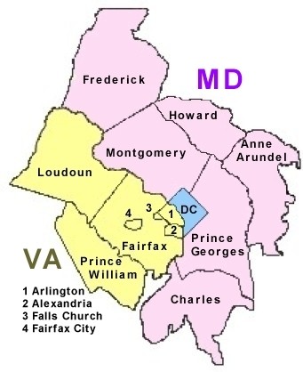
Note that the areas that are now Arlington County and Alexandria were part of DC until 1846.
Copyright © 1996 - The USGenWeb® Project, DCGenWeb

This page was last updated
07/12/2026