Industry
Ogden Rails, A History of Railroading At The Crossroads Of The West
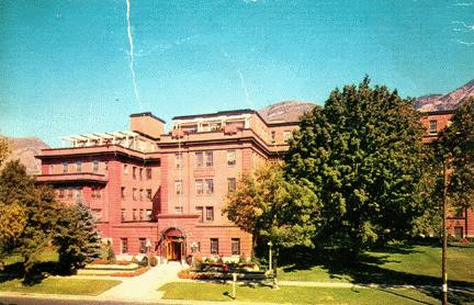
The Thomas D Dee Memorial Hospital, Ogden, UT
Submitted by
Trini Tracy
A modern, well-equipped 220 bed hospital owned and operated by the LDS
Church, located in the West's most picturesque valley----Ogden. Nearby
mountains offer the best in sports and recreation---fishing, deer and elk
hunting, boating, skiing, and duck hunting on the shores of the Great Salt
Lake.
The "Dee" has an active medical staff of 108 doctors, and is fully
accredited by JCAH. The intern-resident training program is fully approved
by the Council of Medical Education and hospitals of AMA.
History of Utah, ... Vol. 1, by Whitney, Orson F., Chapter XXII, 1849-1851, includes creation of numerous counties, etc. - transcribed and contributed by Denise Wells.
Pictorial History of Ogden City
Courtesy of D. Boyd Crawford
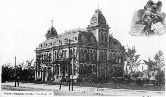
Ogden City Hall
This building was built in 1889 and torn down in the 1930's.
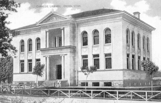
Carnegie Library, Ogden
This building was built in 1902 and torn down in the 1970's.

Masonic Lodge, Ogden
This building was built in 1906 and is still in use as a commercial
structure.
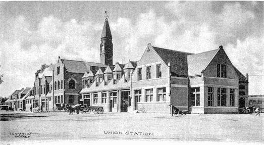
Union Station
This building was built in 1888 and destroyed by fire in 1923.
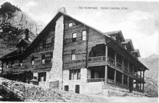
Hermitage Hotel, Ogden Canyon
This building was built in 1905 and destroyed by fire in 1939.
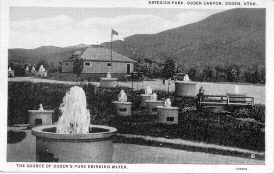
Artesian Wells Park, Ogden Canyon
The wells were drilled in 1915 and the park existed until 1937. This is
now under Pineview Reservoir.
Weber County, Utah Locations
West Weber-aka Alma, Blanchard and Weston, absorbed part of
Garland-located west of Ogden
Eden-aka North Fork Town-located in Ogden Canyon
Farr West-aka West Harrisville-located west of Harrisville
Harrisville-located northwest of Ogden
Roy-aka Central City, The Sandridge, absorbed part of Fairmont-located
west of Riverdale
Plain City-aka City of the Plains, North Weber, Poplar and Skeen-located
west of North Ogden
South Ogden-aka Burch Creek-located south of Ogden
Riverdale-aka John Thompson Settlement, South Weber and Stringtown,
absorbed part of Fairmont-located southwest of Ogden
Uintah-aka Deseret Railroad Station, East Weber and Easton-located south
of South Ogden
Hooper- aka Hooperville and Muskrat Springs-located west of Roy
Slaterville-aka Mill Creek-located west of Marriott
Kanesville-absorbed part of Fairmont-located west of Ogden, north of West
Haven
Liberty-located in Ogden Canyon
Huntsville-aka Hawkins Grove, absorbed Middleton-located in Ogden Canyon
Marriott-located on east side of Ogden, between Ogden and Slaterville
North Ogden-aka North Ogden Fort-located north of Ogden
Warren-aka West Warren, Salt Creek-located northwest of Ogden
Taylor-aka Taylorsville-West of Ogden, north of Kanesville
Pleasant View-Northwest of North Ogden
Washington Terrace-Former military housing now incorporated, south of
Ogden, west of South Ogden, east of Riverdale
Wilson-absorbed part of Garland, absorbed part of Fairmont
West Haven-absorbed Wilson-located north and northwest of Roy
Ogden- aka Brownsville
Bingham Fort-absorbed by Ogden, in area of Five Points in Ogden (2nd
Street, Washington Blvd., US 89)
Farr's Fort-absorbed by Ogden. Built in 1850, abandoned in 1853, now the
1000 block of East Canyon Road.
Mound Fort/Fort Mound-absorbed by Ogden, west of Washington Blvd., between
10th and 12th Streets
Lynn or Lynne-absorbed by Ogden City, in area of Five Points in Ogden
Brown's Fort-former name of Fort Buenaventura, now a historical park in
Ogden
Goodyear's Fort-former name of Fort Buenaventura
Other locations
Fremont Island-formerly Disappointment Island, Castle Island, and Miller
Island, in the Great Salt Lake
Malan's Basin-Ghost town, one and one-half miles east of Ogden