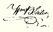
William B. Giles Esqr. governor of the Commonwealth of Virginia
To all to whom these presents shall come greeting, Know Ye, that in Conformity with a survey made on the ninth day of May, 1826; by virtue of two Land office treasury Warrants to wit: 250 acres by No. 6238 issued March 28th 1818; and 63 acres by No. 7858 issued February 9th 1825 there is granted by the said Commonwealth unto Adam Barb junior, a Certain tract or parcel of Land, containing three hundred and thirteen acres situate in the county of Shenandoah, on the West side of Sup and Lick mountains, on some drains of Stony Creek; and Bounded as followeth to wit:
Beginning at two pines on the east branch of a draught at the foot of the Supen Lick mountain, a corner to Adam Tusings Land thence north sixty five degrees East fifty four poles to a white oak chesnut oak and pine, South sixty two degrees East - ninety six poles to a Large chesnut oak and two small hickory grubs on a ridge; thence south twenty six degrees East one hundred and forty eight-poles to a chesnut oak and pine on a ridge, thence north fifty degrees East twenty Eight poles to a large Chesnut oak; thence North thirty four degrees, East two hundred and Sixty four Poles to three pines near the head of a hollow, thence north forty degrees West thirty four poles to a gum dogwood and chesnut oak, at the Edge of a draught, thence south seventy degrees West six poles to three chesnut oaks on the side of a steep ridge a corner to John Sheetz Land, thence with his Line north forty degrees West forty poles to a dogwood and gum on the bank of a dry branch near a large white pine in Sheetz Line a corner to said Barbs other land, thence with a line thereof South thirty degrees West one hundred and twenty poles to a hickory and Locust Saplings in a hollow, another corner said Barb; thence south forty degrees west three hundred and seventy poles to ??? marked pines on the point of a ridge, thence North fifty degrees west seventy two poles to a pine spanish oak and chesnut oak at a path, on the dividing ridge, thence North twenty three and a half degrees East thirteen and a half poles to a pine and red oak sapling, thence south fifty two degrees East seventeen poles to a white oak by the edge of a small march a corner to Henry Tusings Land, thence With his Line north fifty six degrees, west one hundred and twenty four poles to two chesnut oaks and two spanish at or near said Tusings Corner, thence north twenty five degrees West forty Eight poles to two pines and two spanish oak grubs in said Tusings Line, thence Leaving his line south thirty two degrees West one hundred and forty Eight poles to two Chesnut oaks thence North seventy seven degrees west Eight poles to a pine thence south Eleven degrees West thirty six poles to two spanish oaks and a black oak, thence north seventy seven degrees East thirty six poles to a chesnut oak and two spanish oaks in said Adam Tusings Line, thence with his line north twenty six East ninety two poles to two pines on ground oak flat said Tusings Corner, thence with another of his lines south fifty one degrees East two Hundred and four poles to the Beginning.
To have and to hold the said tract or parcel of Land with its appurtenances to the said Adam Barb Junior and his Heirs forever.
In witness whereof the said William B. Giles Esqr. governor of the Commonwealth of Virginia; hath hereunto set his hand and caused the Lesser seal of the said Commonwealth to be affixed at Richmond on the twenty ninth day of September in the Year of our Lord, one thousand eight hundred and twenty seven, and of the Commonwealth the fifty second.

