—JoLee Gregory Spears 2002
Return to the VAGenWeb Charlotte County Project Home Page
Or use you browser "Back" feature to return to the previous page
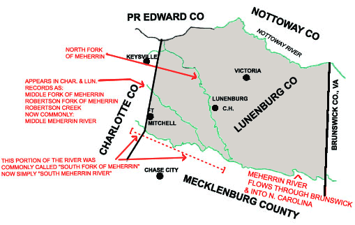
The Forks of
the Meherrin River
&
The Dividing line between Charlotte County and Lunenburg
This drawing is to show how the heads of the forks of Meherrin are barely in Charlotte County. The North and Middle Forks flow southeastwardly through Lunenburg. The South Fork forms the division between Lunenburg and Mecklenburg before the forks join to form the Meherrin which divides the rest of Lunenburg from Mecklenburg. The various labels given the Middle Fork (or Middle Meherrin) in deeds sometimes create confusion. It was frequently referred to as "Robertson Fork of Meherrin" and sometimes, Robertson Creek. |
—JoLee Gregory Spears 2002
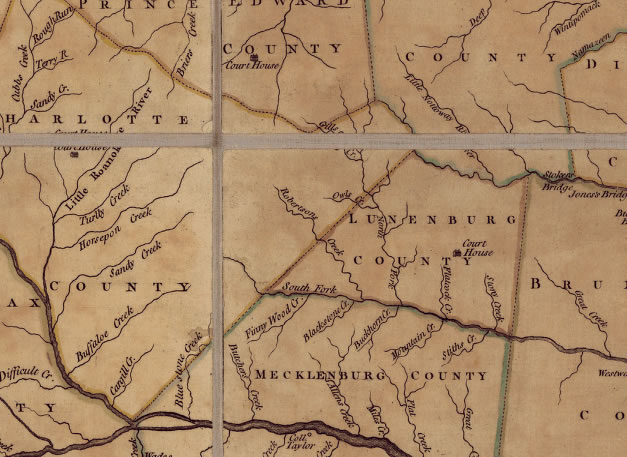
The below map section shows the Lunenburg/Charlotte Co., VA line as it was in 1770. This was five (5) years after Charlotte County was formed from Cornwall Parish, Lunenburg County, and seven (7) years before the change in 1777 from the point the South Fork of Meherrin joins the Lunenburg/Charlotte dividing line and northward. From Charlotte County-Rich Indeed, p. 62 "Whereas part of the parish of Cornwall and county of Charlotte,
is very inconvenient for the inhabitants thereof, and would be more
convenient to the parish of Cumberland and county of Lunenburg: Be it
therefore enacted, that the surveyor of the said county of Lunenburg
shall, on or before the first day of October next, run a line, to begin
WHERE MECKLENBURG AND LUNENBURG STRIKE CHARLOTTE COUNTY LINE, DIRECTLY
TO THE PLACE CALLED WIMBUSH'S ORDINARY; and that all that part of the
said parish of Cornwall, and county of Charlotte, which shall lie on
the east side of the said line, shall from thenceforth be add to the
parish of Cumberland and county of Lunenburg." Following is the full reference to the map and a search method to find
it online:
|