The first table contains data on the former town of Downes. It is on Log Cabin Road (Route 312) at an unused railroad crossing between Hillsboro Ridgely Road (Route 480) and Hillsboro Denton Road (Route 404). It appears to have been a railroad stop (jerkwater town?) as unused tracks still are in place. Most current maps do not depict the town nor the railroad. The railroad appears to end in Denton. The area is mostly farming with only three houses near the tracks. Just one appears to be more than fifty years old.
The second table contains data on a Downes Landing on the Choptank River. The area is primarily farmland with several large homes built in the area of Downes Landing. A scenic drive to Downes Landing can start at Hillsboro or across the Tuckahoe Creek in Queen Anne, Talbot County. From Main Street (Route 404) turn onto Tuckahoe Road. After crossing the Easton Denton Road (Route 328) Tuckahoe Road narrows. It is about a mile to the Downes Landing area.
The third table contains data on a former Downes post office.
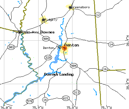
Last is a graphic depicting the relative locations of the town, Downes, and the "Downes Landing."
![]()
| Feature Name: | Downes |
| Feature Type: | Populated place |
| Elevation: | 57 feet |
| State: | Maryland |
| County: | Caroline |
| USGS Map: | Ridgely |
| Latitude: | 385516N |
| Longitude: | 0755334W |
![]()
| Feature Name: | Downes Landing |
| Feature Type: | Locale |
| State: | Maryland |
| County: | Caroline |
| USGS Map: | Ridgely |
| Latitude: | 385516N |
| Longitude: | 0755243W |
![]()
| Feature Name: | Downes Post Office |
| Feature Type: | Post office |
| State: | Maryland |
| County: | Caroline |
| USGS Map: | Ridgely |
| Latitude: | UNKNOWN |
| Longitude: | UNKNOWN |
![]()
US Gazetteer Place and Zipcode files .
![]()
Copyright © 1997 - The MDGenWeb Project