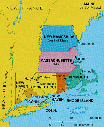
 1650 New England |
Windham & Vermont |
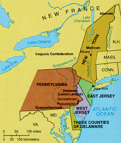 1685 New England |
|
1650 New England |
Windham & Vermont |
1685 New England |
Historical Maps to Help Identify Early State and County Locations
|
||||||||||||||||||||||||
MAPS
· Vermont
Area Map of ca. 1756: An accurate map of His Majesty's Province of
New-Hampshire in New England & all the adjacent country northward to the
River St. Lawrence, & eastward to Penobscot Bay, containing the
principal places which relate to the present war on the continent of
North America. By Saml. Langdon
(1723-1797).
· Ca.
1780 Map which shows land grants and purchases in northeastern New York
State and granted townships in Vermont and parts of New Hampshire, and
Massachusetts: A chorographical map of the Northern Department of
North-America, drawn from the latest and most accurate observations, at
Amsterdam by Cóvens and Mortier and Cóvens,
junior. By H. Klockhoff,
sculp., [Amsterdam] 1780. Repository: Library of Congress
Geography and Map Division Washington, D.C. 20540-4650 USA, url:
<http://hdl.loc.gov/loc.gmd/g3715.ar082800>
· Ca.
1781 Map: An Accurate map of New Hampshire in New England, from a late
survey. [London, 1781]. From the Universal magazine of
knowledge and pleasure. March, 1781. Repository: Library of Congress
Geography and Map Division Washington, D.C. 20540-4650 USA, url:
<http://hdl.loc.gov/loc.gmd/g3740.ar087200>
· Ca.
1784 Map: An accurate map of the State and Province of New-Hampshire in
New England, taken from actual surveys of all the inhabited part,
and from the best information of what is uninhabited, together with the
adjacent countries, which exhibits the theatre of this war in that part
of the world, by Col. Blanchard and the Revd. Mr.
Langdon. Engraved by Thomas Jefferys.
With many additions by Abel Sawyer. Boston, 1784. Repository:
Library of Congress Geography and Map Division Washington, D.C.
20540-4650 USA, url: <http://hdl.loc.gov/loc.gmd/g3740.ar087100>
· 1795
Map of Vermont, from actual survey. By Doolittle, Amos
(1754-1832). From Carey's American Atlas, Philadelphia,
1795. DLC. Philadelphia, 1795. Repository:
Library of Congress Geography and Map Division Washington, D.C.
20540-4650 USA, url: <http://hdl.loc.gov/loc.gmd/g3750.ct000093>
· 1814
Map of Vermont, from actual survey. By Carey, Mathew (1760-1839).
From Carey's General Atlas of the World. DLC. [S.l.],
1814. Repository: Library of Congress Geography and Map
Division Washington, D.C. 20540-4650 USA, url:
<http://hdl.loc.gov/loc.gmd/g3750.ct000094>
· Vermont
Maps – Middlebury College digital collections. · GIS Windham Regional Commission - Maps |
||||||||||||||||||||||||