Grayson County Deed Records
Vol. 39/pg. 170
State of Texas
County of Grayson
Know all men by these presents that we
M.G. Taylor, I.B. Taylor in
consideration of the sum of Eleven
hundred and twenty four & 00/00 of
which 621.35 is in hand paid the receipt
of which is hereby acknowledged and the
balance evidenced by two promissory note
both signed by T.R. Taylor one of them
payable to M.G. Taylor for 181.22 and
due December 27, 18-- both bearing
interest from date at rate of ten per
cent per annum to secure which a
vendor's lien is hereby retained have
granted, bargained and sold and by these
presents do grant, bargain, sell and
convey unto said T.R. Taylor our
interest in the following described
tracts of land all situated in said
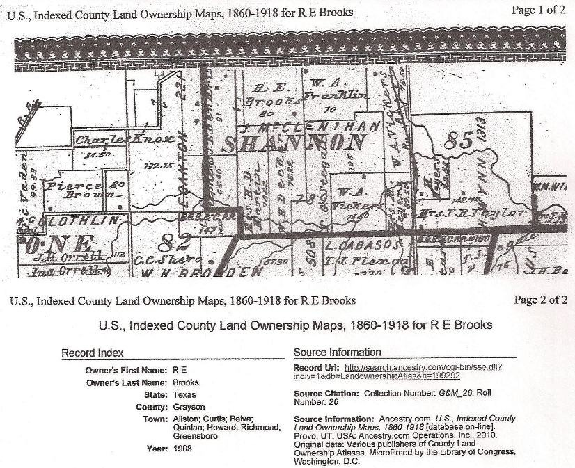
State and County and in a survey in the
name of Harmon Winn
1st tract described as follows:
Being part of 100 acres mentioned in
Book F page 155 of Grayson County
Records
Beginning at the S.W. corner of said 100
acres and being 440 vrs W from the SE
corner of the Winn Survey. Thence
N with the West line of said 100 acres
608 vrs to the bed of Shannon Creek.
Thence down said creek with its
meanders until it crosses the E line of
the Winn Surveyat the mouth of a branch.
Thence up said branch up said
creek where it crosses the South line of
the Winns Survey.Thence West with said
line with said South line 360 vrs to the
place of beginning containing 24-1/2
acres more or less.
2nd tract described as follows:
Beginning at the NW corner of Henry B.
Taylor's survey of 45 acres at a stake
from which a gray ash marked "A"
bears240 E 3-1/2 vrs. Thence East
503 vrs to the NE corner of Taylor's
survey. Thence N with the said
East line to Shannon's creek. Then
with the creek where the West line of
120 acres survey crossed said creek.
Thence S with said line to the
beginning containing 43-3/4 acres.
3rd tract described as follows:
Beginning at 420-1/2 vrs N from the SW
corner of said Winns original survey a
post from which a forked pecan marked
"x" & bears N 48 degrees E 2 vrs.
Thence East 503 - to a post from
which a Spanish oak marked "x" N
49 West . Thence N for enough to
include half of the A.D. Moore tract of
land or 45 acres by running West
straight angles to the West line of said
A.D. Moore's 90 acre Survey.
Thence S to the beginning
containing 45 acres.
To have and to hold said above described
tracts of land unto him the said T.R.
Taylor, his heirs and assigns forever,
together with all and singular the
rights members hereditments and
appurtances to said bargained tracts
belonging or in any wise incident or
appertaining And we the said M.G. Taylor
and J.B. Taylor hereby bind ourselves
our heirs executors and administrators
to warrant and forever defend all and
singular the interest herein conveyed in
the above tracts against all persons
whomsoever lawfully claiming or to claim
the same or any part thereof by through
or under us
Witness our hands this 1st day of
February 1878
M.G. Taylor
J.B. Taylor
STATE OF TEXAS
COUNTY OF GRAYSON
Before me S S Fears a notary public
personally came M.G. Taylor - J.B.
Taylor to me known and acknowledged they
sign and delivered the foregoing Deed
for the purpose and consideration
therein expressed.
Given under my hand and official seal on
this the 1st day of February 1878.
S S Fears
Not Pub
Filed Feb. 2nd 1878 at 2 p.m.
Recorded Feb 27th 1878
G.A. Dickerman, Clerk