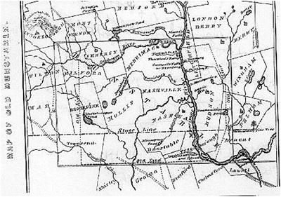
 Nearly all the territory embraced within the bounds of the present Hillsborough
County, New Hampshire, originally comprised a portion of the old town of
Dunstable, which was granted by Massachusetts October 16, 1673 (O.S.), and
embraced the present town of Tyngsborough, the east part of Dunstable, a narrow
gore on the east side of Pepperell and a tract in the northeast part of
Townsend, Mass., and the towns of Litchfield, Hudson, portions of Londonderry,
Pelham and nearly all the present towns of Nashua and Hollis and parts of
Amherst, Milford and Brookline, in New Hampshire.
December 28, 1739, the
westerly portion of Dunstable was erected into a separate and distinct precinct
by the government of Massachusetts, and went by the name of West Dunstable until
April 3, 1746, when, in answer to a petition from the inhabitants, about
one-half of it was incorporated with full town privileges by the Governor and
Council of the province of New Hampshire, and named Holles.
Contributed by Ann Mensch, found in History of the Old Township of Dunstable including Nashua, Nashville, Hollis, Hudson, Litchfield and Merrimac, N. H.; Dunstable and Tyngsborough, Mass by Charles J. Fox. Nashua: Charles T. Gill Publishers. 1846.
The township of Hollis was entirely included within the Dunstable
grant, and continued to form a part of Dunstable until December 28,
1739, when it was set off as the "West Parish of Dunstable," and soon
after was incorporated into a separate township by the name of Hollis.
Its Indian name was Nisitisset. It was incorporated by the Legislature
of New Hampshire, April 3, 1746.
The eariiest settlement in
Hollis was made in 1730, by Capt. Peter Powers, who was born in
Littleton, Mass., in 1707. In 1728, he married Anna Rogers, of
Chelmsford, who was born in 1708. He had been a soldier in 1725, under
Capt. Lovewell, and on his return settled at Dunstable. Here he brought
his wife upon his marriage, and resided about two years. In the fall of
1730, he crossed the Nashua, — built him cabin in the forest, and in
January, 1731, with his wife and two small children, took up his abode
in Hollis. The remains of his dwelling were visible in 1830, "a little
southwest of the dwelling house of Thomas Cummings."
Source: History of the Old Township of Dunstable, by Charles J. Fox, published in 1846, pages 229-230.
We have seen that this town was included in the original grant of
Dunstable, and was set off into a separate township by the General
Assembly of Massachusetts in 1732, by the name of Nottingham. After the
establishment of the boundary line, by which it fell within the limits
and jurisdiction of New Hampshire, it received a new act of
incorporation, July 5, 1746, and its name was changed to Nottingham
West, there being already a Nottingham in the eastern section of the
state. A small addition was made to its territory, by annexing a part of
Londonderry, March 6, 1778, and the township now contains 17,379 acres.
July 1, 1830, its name was changed by the Legislature to Hudson.
Hudson was not settled until after 1710, although several tracts of land
within its bounds were granted before 1660. The names of some of the
early settlers were Blodgett, Colburn, Cross, (taken captive at
Dunstable, in 1724,) Cummings, Greeley, Hill, Lovewell, Marsh, Merrill,
Pollard, and Winn. The first settlements were made on the banks of the
Merrimac where the Indians had cleared fields for cultivating corn. The
first settlers lived in garrisons, but there is no record that any
depredations were ever committed by the Indians in this town. — Near the
Indian cornfields have been found cinders, like those of a blacksmith's
forge, which have led to the conjecture that they employed a smith to
manufacture their implements of war and agriculture.
Source: History of the Old Township of Dunstable, by Charles J. Fox, published in 1846, pages 216-217.
The greater part of the township of Litchfield was granted, as we
have seen, as early as 1656, to William Brenton, and called "Brenton's
Farm." Its Indian name was Naticook, and the intervale portions of the
town, as well as of Merrimac, Hudson, and Nashua, were inhabited and
cultivated by a branch of the Penacooks, called sometimes, the
Naticooks. It was settled about 1720, but when and by whom is unknown.
Of the early settlers some were from Billerica, and some from
Chelmsford, and among them were the names of Underwood, Chase, Bixby,
Tufts and Parker. It was set off from Dunstable, and incorporated by
Massachusetts as a township, extending on both sides of Merrimac river,
July 5, 1734. The charter was afterwards confirmed by New Hampshire,
June 5, 1749, the Merrimac being established as its western boundary. It
contains 8,426 acres.
In the petition for incorporation, signed
by Aquila Underwood in behalf of the town, dated May, 1734, it is said
''that they have supported a minister for some time." This was probably
Rev. Joshua Tafts, who was settled in 1736, and dismissed in 1744.
Source: History of the Old Township of Dunstable, by Charles J. Fox, published in 1846, pages 220-221.
The area was part of a 200-square-mile (520 km2) tract of land in Massachusetts called Dunstable, which had been awarded to Edward Tyng of Dunstable, England. Nashua lies approximately in the center of the original 1673 grant. The previously disputed boundary between Massachusetts and New Hampshire was fixed in 1741 when the governorships of the two provinces were separated. As a consequence, the township of Dunstable was divided in two. Tyngsborough and some of Dunstable remained in Massachusetts, while Dunstable, New Hampshire, was incorporated in 1746 from the northern section of the town.
Located at the confluence of the Nashua and Merrimack rivers, Dunstable was first settled about 1655 as a fur trading town. Like many 19th century riverfront New England communities, it would be developed during the Industrial Revolution with textile mills operated from water power. By 1836, the Nashua Manufacturing Company had built three cotton mills which produced 9.3 million yards of cloth annually on 710 looms. On December 31, 1836, the New Hampshire half of Dunstable was renamed Nashua, after the Nashua River, by a declaration of the New Hampshire legislature (the Dunstable name lives on across the Massachusetts border).The Nashua River was named by the Nashuway Indians, and in the Penacook language it means "beautiful stream with a pebbly bottom," with an alternative meaning of “land between two rivers.” In 1842 the town split again in two for eleven years following a dispute between the area north of the Nashua, and the area south of the river. During that time the northern area (today "French Hill") called itself "Nashville," while the southern part kept the name Nashua. They reconciled in 1853 and joined together to charter the "city of Nashua". Six railroad lines crossed the mill town, namely the Boston, Lowell and Nashua; Worcester and Nashua; Nashua and Acton; Nashua and Wilton; Concord and Nashua; and Rochester railroads; with 56 trains entering and departing daily in the years before the Civil War. These various railroads led to all sections of the country, north, east, south, and west. The Jackson Manufacturing Company employed hundreds of workers in the 1870s.
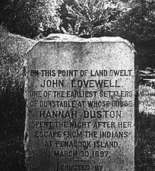
 On
this point of land dwelt John Lovewell, one of the earliest settlers of
Dunstable, at whose house Hannah Duston spent the night after her escape
from the Indians at Penacook Island March 30, 1697.
Source: Unknown.
Copyright © 1996 - The USGenWeb® Project, NHGenWeb, Hillsborough County