

Aroostook County
MEGenWeb

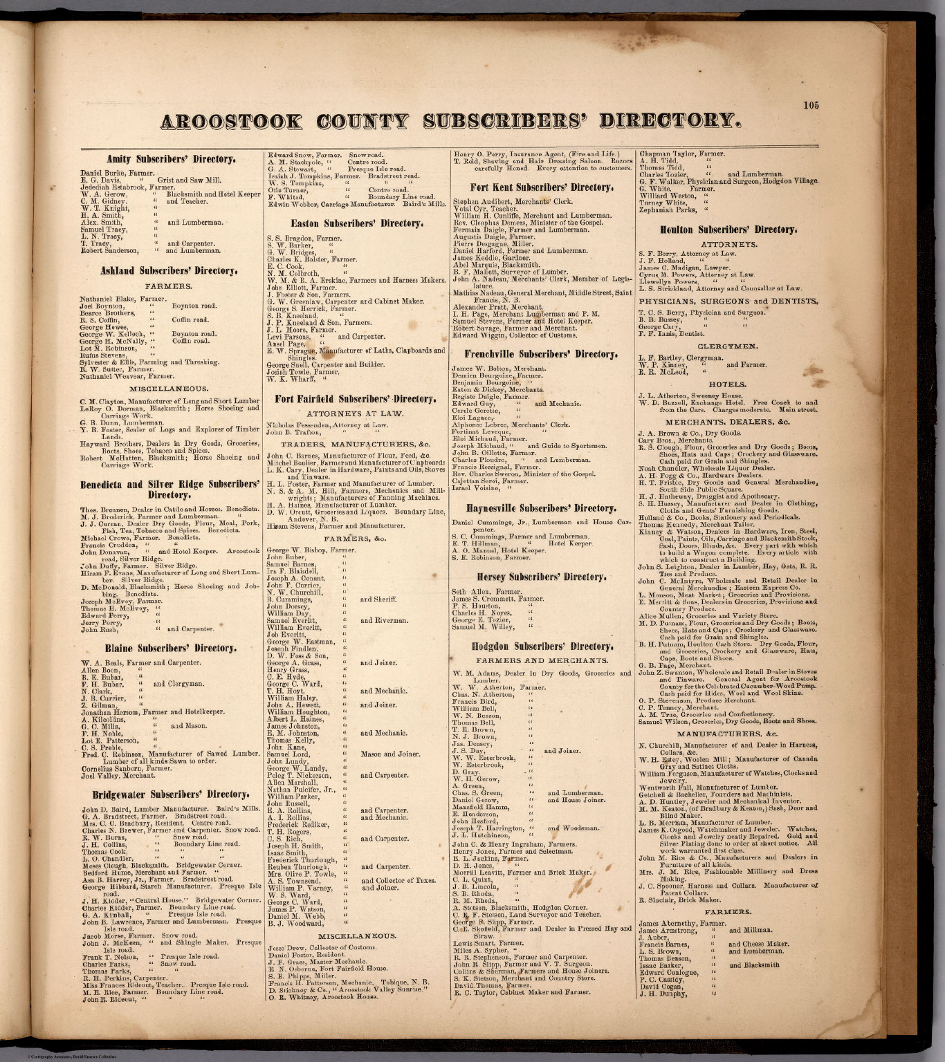
1876 Atlas Subscribers Directory, Page 105
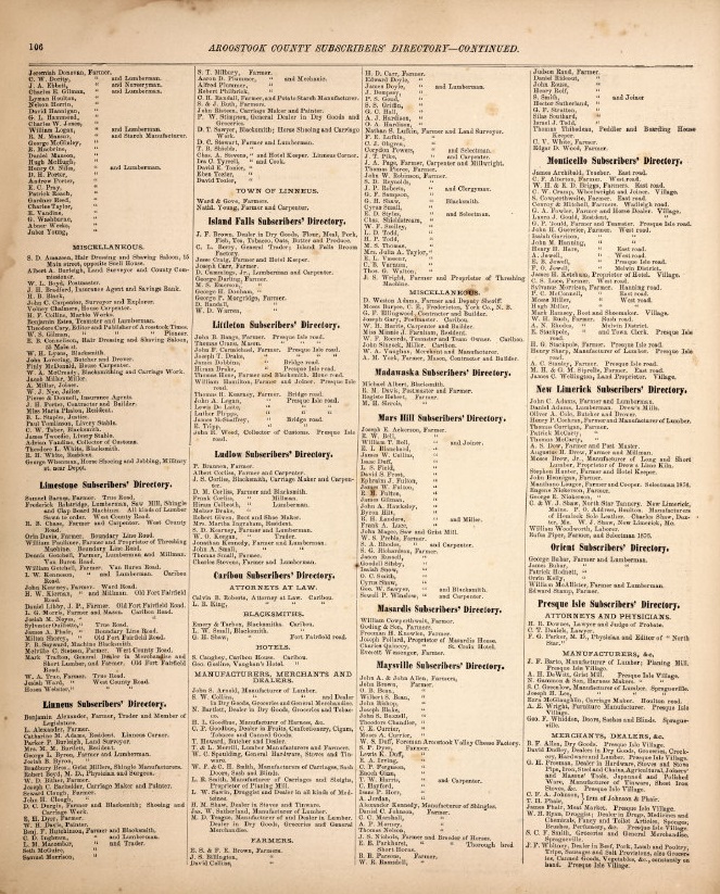
1876 Atlas Subscribers Directory, Page 106
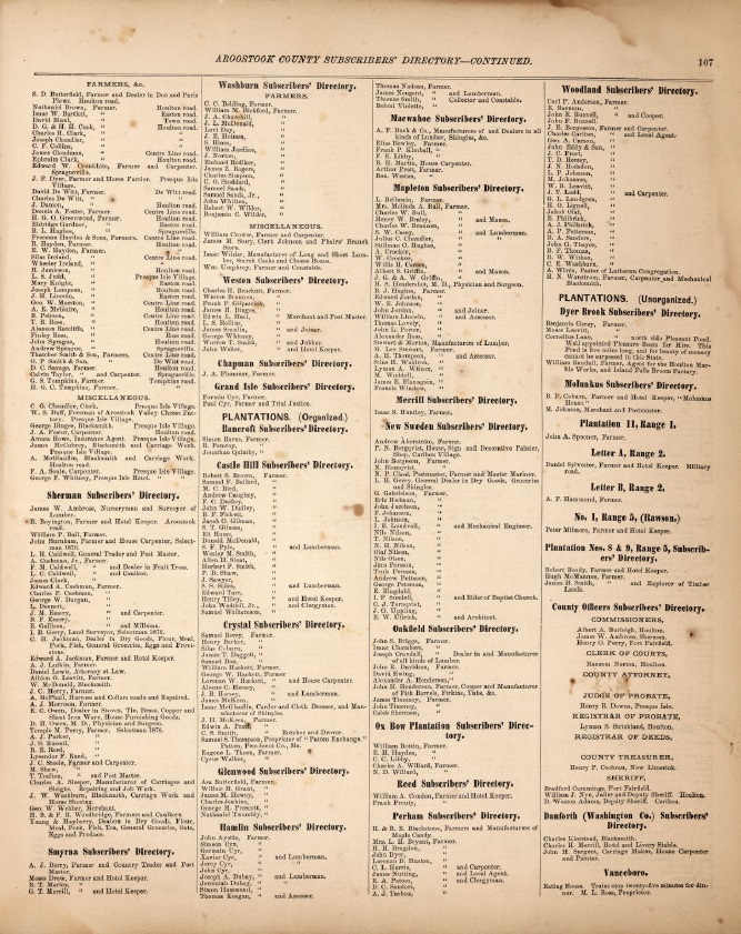
1876 Atlas Subscribers Directory, Page 107
Caribou
1940
... The Acadian colony was never very prosperous. Two years after the first
cabins were built at Port Royal, part of the colony moved across the bay and
settled at the mouth of the St. John river. Soon after a large strip was clipped
off the western part of the grant and given to some colonists in Canada. Hard
winters followed with sickness and famine, and the great bulk of the French
emigrants were going up the St. Lawrence and to the great lakes. So we find that
at the beginning of the year 1790 there were scarcely 20,000 white people in all
Acadia and probably not a dozen in all Aroostook county. Other troubles had
come; bands of English traders with their long whiskers and blue eyes, and armed
to the teeth, were constantly coming up the river They hated the docile French
and their religion but they loved the Indian as long as they could make a
shilling out of him. In this time the Indians had decreased in numbers, too. The
great Gaspesian tribe had moved northward to the St Lawrence, the Abenakis had
moved south and afterwards became the. Passamaquoddies and the MicMacs occupied
Aroostook territory. ...
Source: History of Aroostook County, by W. T. Ashby, 1910, Chapter 3.
"Acadian culture and heritage is well represented in the county. In
the Saint John Valley (northern Aroostook county), many of the residents
are bilingual in English and Acadian French. New England French is the
predominant form of French spoken in the rest of Maine."
Source: unknown.
The same spring another great change took place in Aroostook. The settlers, all British subjects, who had always cherished such bitter hate against the Americans, especially against the Maine Yankees, now, with very few exceptions, sided with the Americans, not only in word, but in deed. It is true, they and their teams had been pressed into the service of the state and made to work early and late; their timber had been seized and their camp property had been confiscated, but they had been used like men and paid like men. The officers and engineers treated them as equals, and often allowed them to visit their homes with only their word to assure their return. And those rabid Bluenoses now expressed a desire to live and die in their beloved Aroostook, and sincerely hoped it might be under the American flag. There were a few exceptions, however, Peter Bull, James Fitzherbert, Richard Hox, George Rodgers, John Twaddle, John Bradley, DavidWark and a few others, when they saw the disputed territory was about to go to Maine, moved to New Brunswick. Benj. Weeks, who had long held a British land patent on the Johnson brook, including about all the land in the present village of Fort Fairfield, had waited patiently for the border trouble to be settled so that he could build his mills, and was much disgusted as he saw his property slipping from his grasp. He did not leave the territory, but traded his land patent with William Johnson for a squatter's right on the Reach. The U. S. Government honored the patent and Johnson held the land. But the Bishops, Doyls, Russells, Dorseys, Johnsons, Armstrongs, Uptons, McDougals, Fairbanks, Cochrans and the Whitneys, remained and laid the foundation for the greatest county in New England.
Source: History of Aroostook County, by W. T. Ashby, 1910, Chapter 19
The great County of Aroostook is yet in the morning of its day: located as it
is geographically, it is destined to become the cornerstone of this great
Republic. As the northeast corner of King Solomon's temple became the most
important angle of that vast building so will Aroostook be to the United States.
No wonder it is called the "New Northeast" for Aroostook County has an
area of 6500 square miles; it is much larger than any county in the State,
larger than the State of Connecticut and contains almost as much territory as
the State of Massachusetts. There is in the county 100 townships of wild land
heavily covered with virgin forests of valuable timber; underneath this primeval
wilderness is a deep rich soil awaiting husbandman. It is hard to compute in
dollars today the value of the Aroostook forests. Cedar, that durable wood,
grows abundantly on the low lands. More shingles and railroad ties are shipped
from Aroostook annually than all the rest of New England produces. It is
estimated that Aroostook contains cedar enough to lay ties for a broad gauge
railroad around the globe and then have enough left to set a line of telegraph
poles beside it.
Spruce, the king of all trees now growing in the East
grows abundantly all over the county; so rapid is the growth of the spruce, that
a seed dropped in an old pasture will become a tree a foot in diameter in 20
years. I'he hard wood growth on the ridges, so called, is very heavy; nowhere
else in the east do trees grow so large; the giant birches, beech and sugar
maples grow tall and straight and are free rifted, while the ash and elm are
unsurpassed in any. land. The giant pumpkin pines—most of them are gone now,
grew so tall that they seemed to reach the sky, but of these we will speak
later. The hard woods of Aroostook are among the most valuable in the world; for
carriage’ and cabinet work they have no equal. A carriage made of seasoned
Aroostook iumber will weigh a third more than one made of the same kind of wood
from one of the western states. Ax shelves or peavy stocks made of Aroostook
rock maple will stand a much greater strain than those made from the same wood
in Michigan, New York or Vermont. Altogether the forests of Aroostook are a
valuable asset—worth more than the mines of Colorado or Pennsylvania on the same
amount of territory.
Today these woods are swarming with countless
numbers of deer, great droves of moose, bears, beaver, lynx and scores of other
valuable fur bearing animals. The beautiful lakes are alive with the gamy trout,
salmon and other freshwater fish and a variety of game birds make their home
around the lakes and in the woods. The big woods of Maine is now about the only
big forest left in the United States and more than half of it is in Aroostook
county. It is the game preserve of the nation today and will be for years to
come. Besides the one hundred townships of wild land mentioned above Aroostook
has 44 organized or incorporated towns and 26 plantations. Each township
contains 36 square miles. The population at the elope of the so-called Aroostook
war in.1840 was 9413, in 1900 it was 60,744, in that year there were 3843 polls
in the county. In 1906 the county had 16,732 polls. If the population now bears
thesame ratio to polls as it did. In 1900 the population today is over 80,000, a
gain of about 20 percent in the last six years. The towns and plantations that
are settled are nearly all on the northeastern.and eastern border of the county
extending from the St. Francis river on the north to Orient in the southern part
of the county, a distance of nearly 200 miles. We will tell later on how this
happened.
Aroostook County is bounded on the North and East by the
Canadian province of New Brunswick, on the West by the Province of Quebec and on
the South by Somerset, Piscataquis, Penobscot and Washington counties.
Underneath is a solid bed of limestone and above Heaven.
In 1900 the
largest towns in the county were Caribou, with a population of 4,768, Houlton
4680, Fort Fairfield 4,181, Presque Isle 3,804, Fort Kent 2,528, Van Buren
1,878, Madawaska 1,698.
Some 15 other towns then had a population of
over 1000. Some of the small towns have doubled their population since 1900.
Source: History of Aroostook County, by W. T. Ashby, 1910, Chapter 1
At the close of the war, Queen Anne war, when the English changed the name of Port Royal to Annapolis, all the territory east of the Penobscot River was named Nova Scotia so you see, our historic Aroostook territory was part of Acadia under the French, Nova Scotia under the English, and later New Brunswick under the Canadians. We all know to what nation it belongs to now. The term Nova Scotia was not generally applied to the territory till at the close of the Revolutionary war. At that time the territory west of the Bay of Fundy was New Brunswick, which included Aroostook. Then Nova Scotia became the common name for the peninsula."
Source: History of Aroostook County, by W. T. Ashby, 1910, Chapter 7
As the years passed by, the settlers commenced
to clear up little patches of land. Potatoes were a necessity, and to bring them
from the Province in winter was an impossibility. As near as we can learn, the
first potatoes planted in the Aroostook Valley were planted at the mouth of the
Lovely brook in Letter G. Township, by one William Lovely, one of the early
settlers. He had a little patch of new land and his wife insisted he should get
some potatoes and plant them. So Lovely took his canoe and started to New
Brunswick. It was a long, crooked route by water; the Aroostook Falls had to be
carried around going and coming, but there were no customs officers to interfere
and in those days he returned with a bushel of potatoes. They looked so good
that the family ate about half of them, and the rest were planted. The story
goes that Lovely took a spade and dug holes that would hold about half a bushel
each and his wife followed behind and dropped a seed into each hole and kicked
in some dirt.
When fall came Lovely had forgotten all about his potato
crop but his wife had not; so one Sunday morning they went out to investigate.
They uncovered a hill and it was full to the brim with great, smooth , handsome,
potatoes; some of them weighed two pounds. The good wife filled her apron and
William filled his hat with the products of their first harvest, and they
returned to the cabin. When the potatoes were cooked they proved to be better
than any they had ever eaten. The yield from the half bushel planting filled the
little hole under the house they called a cellar, and there was nearly 50
bushels that had to be pitted out of the field.
Those potatoes were a
variety known as the "Early Blues." The seed end was a bluish purple tint and
they were called "Bluenoses,” or the blue nosed potato. When the soldiers came
in after years they were supplied with this variety which they were very fond
of, and they got to calling the people who raised them "Blue Noses." The name
stuck and from Maine to California, the people of New Brunswick are known as
"Blue noses." At first they used to resent being called a Bluenose, but today
they appear to be proud of the title.
Source: History of Aroostook County, by W. T. Ashby, 1910, Chapter 16
Before the war, all the mail that came to Aroostook territory came from New Brunswick. There was a post office at Tobique. When the soldiers came the communications with Tobique were cut off. After the military road was cut through from Houlton, David Bubar, the Aroostook giant, of whom I shall mention later, was hired to carry the mail to and from Houlton. He made two trips per month. There was no road then through what are now the towns of Easton and Mars Hill, and Mr. Bubar traveled via Presque Isle. He made the trips on foot. The mail to Houlton had always come from Woodstock, NB. In 1828, a mail route was established between Mattawamkeag and Houlton. The mail to Fort Kent came from Patten and was carried by Acadians on horseback once a week. It cost at least 25 cents to send a letter.
Source: History of Aroostook County, by W. T. Ashby, 1910, Chapter 20
He was the first surveyor who ever
set foot in the Aroostook wilderness. He was born in Massachusetts and was a
young lieutenant in the Continental army and served in the war of the
Revolution. He was an educated man and one of the best surveyors of his time
when given a fair chance. But his work in Aroostook was not a very good job. He
was the first man to blaze out the line from the source of the St. Croix
northward to the St. John river. Early in the 19th century he surveyed the
grants in the southern part of what is now Aroostook County, and in 1806 was
sent to survey some grants on the Aroostook river. His orders were to measure 50
miles from the monument and run out a township of land; he got north, however,
more than 50 miles and his line on the boundary did not correspond with the
survey that was made in 1842 as it was over 200 feet farther eastward than the
permanent survey, where the two lines struck the St John river. Consequently the
two lines formed a long, narrow V with the angle on the starting point at the
monument.
But Mr. Holland's was only a preliminary survey and was made as
a test to see what the New Brunswick government would say or do. He was poorly
supported and his time was limited. As he had to measure around great trees and
over windfalls, lakes and streams, we wonder that he did as well as he did. He
died in Bangor in 1844, when nearly 100 years old. He predicted great things for
Aroostook. He noted the heavy forest growth and reasoned that a rich, fertile
soil must lie underneath. Where trees had been uprooted he noticed the soil was
rich and mellow. He admired the clear, sparkling river, the crystal lakes and
the pure bracing air. In the last years of his life, had been settled and a new
county created, he predicted that the time would come when the favored land
would be covered with a network of railways, would outstrip and excel in wealth
and population all the other counties in Maine and finely become a state and a
bright star on the National banner.
Source: History of Aroostook County, by W. T. Ashby, 1910, Chapter 29
Copyright © 1996- The USGenWeb® Project, MEGenWeb, Aroostook County
Design by Templates in Time
This page was last updated 08/22/2024