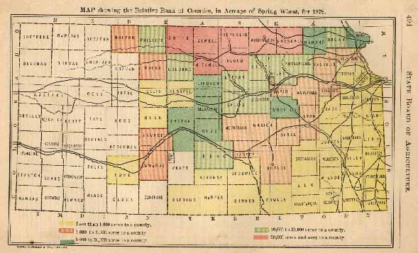
The increase in acreage of spring wheat this year over last was actually more than the entire acreage last year, the ratio of gain being one hundred and nine per cent., and there were seven acres in 1878 to every one in 1872.
The spring-wheat belt, that is, the seven counties having upwards of 20,000 acres, lies in one compact body in the northwest, five of the counties - Marshall, Washington, Republic, Jewell and Smith - being upon the extreme northern border, and the other two - Cloud and Mitchell - adjoining. The following, showing the spring-wheat acreage in these seven counties in 1877 and 1878, and the increase, and the acreage in 1872, will be found of interest, the counties, the different years, being given as they ranked in acreage:
| Acreage 1877. | Acreage 1878. | Increase 1878 Over 1877 |
Acreage 1872. | ||||
| Washington | 33,438 | Marshall | 37,220 | Republic | 18,843 | Marshall | 8,990 |
| Marshall | 21,224 | Republic | 36,429 | Jewell | 18,359 | Republic | 3,599 |
| Republic | 17,586 | Jewel | 30,313 | Mitchell | 17,148 | Washington | 3,393 |
| Jewell | 11,954 | Cloud | 27,104 | Could | 16,560 | Cloud | 2,107 |
| Smith | 10,994 | Washington | 26,187 | Marshall | 15,996 | Mitchell | 778 |
| Cloud | 10,544 | Mitchell | 25,682 | Smith | 13,379 | Jewell | 271 |
| Mitchell | 8,534 | Smith | 24,373 | Washington | *7,251 | Smith | 110 |
| 114,274 | 207,308 | 93,034 | 19,248 | ||||
In 1872, the acreage of these seven counties was 30 per cent. of the spring-wheat acreage of the State, in 1878 it was nearly 48 per cent., while the increase in the seven counties was 41 per cent. of the acreage of the State. The second belt embraces counties having over 10,000 and less than 20,000 acres, and almost entirely confined to the west and northwest, Reno being the only county in the southwest. The other nine counties in this belt - Brown, Dickinson, Clay, Ottawa, Phillips, Saline, Osborne, Riley and Pottawatomie - with the single exception of the first named, all lie contiguous to the counties comprising the main spring-wheat belt. The third belt, 5,000 to 10,000 acres, embraces Nemaha, Lincoln, Ellsworth, Morris, Barton and Rice.
TABLE showing the Number of Acres of Spring Wheat in each County to the Square Mile for 1878, arranged in seven groups of ten counties each, commencing with the highest.
| ACRES | ACRES | ACRES | |||
| Republic | 50.59 | Marion | 5.23 | Anderson | 0.34 |
| Marshall | 41.35 | Wabaunsee | 4.78 | Leavenworth | 0.34 |
| Cloud | 37.64 | McPherson | 4.72 | Ellis | 0.29 |
| Mitchell | 35.66 | Barton | 4.68 | ||
| Jewell | 33.68 | Chase | 4.40 | Linn | 0.29 |
| Washington | 29.09 | Lyon | 3.46 | Ford | 0.24 |
| Smith | 27.08 | Greenwood | 0.17 | ||
| Brown | 25.20 | Harvey | 3.43 | Franklin | 0.13 |
| Dickinson | 22.56 | Jackson | 2.60 | Bourbon | 0.12 |
| Clay | 21.32 | Shawnee | 2.56 | Wyandotte | 0.11 |
| Atchison | 2.48 | Barbour | 0.10 | ||
| Doniphan | 21.15 | Pawnee | 2.19 | Johnson | 0.06 |
| Riley | 16.63 | Norton | 1.88 | Montgomery | 0.06 |
| Ottawa | 16.51 | Butler | 1.81 | Neosho | 0.06 |
| Saline | 15.26 | Edwards | 1.50 | ||
| Morris | 13.29 | Rooks | 1.42 | Woodson | 0.06 |
| Reno | 13.19 | Rush | 1.36 | Cherrokee | 0.04 |
| Phillips | 12.77 | Crawford | 0.04 | ||
| Nemaha | 12.10 | Russell | 0.99 | Chantauqua | 0.02 |
| Rice | 11.96 | Osage | 0.88 | Labette | 0.02 |
| Pottawatomie | 11.85 | Sedgwick | 0.79 | Elk | 0.003 |
| Douglas | 0.62 | Sumner | 0.003 | ||
| Osborne | 11.78 | Jefferson | 0.51 | Wilson | 0.003 |
| Lincoln | 8.52 | Allen | 0.42 | Cowley | 0.000 |
| Davis | 7.85 | Coffey | 0.40 | Miami | 0.000 |
| Ellsworth | 7.81 |
* Decrease.

![]()
