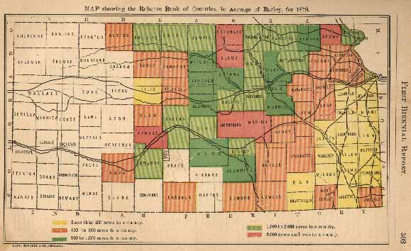
There is a decrease in barley acreage to report, that of 1878 showing an aggregate of 56,255 to 79,704 in 1877 - less this year by something over 29 per cent. than last year.
The main barley belt may be said to be subdivided, three of the leading six counties - those having upwards of 2,000 acres - being in the north and the northwest, and the other three in the southwest. In rank of acreage, Republic, Brown and Cloud, in the northwest, are first, second and fifth, respectively, and McPherson, Pawnee and Marion, in the southwest, third, fourth and sixth. Rice, adjoining McPherson, in the southwest, lacks but 91 acres of coming within the main belt, and Jewell, adjoining Republic, in the northwest, but 120 acres.
The following tabular statement shows the acreage of the counties embraced in the first belt in 1877 and in 1878, the increase this year over last, and the acreage in these same counties in 1872, the counties being so placed as to show their relative rank in the different columns:
| ACREAGE 1877. | ACREAGE 1878. | INCREASE 1878 OVER 1877. | AGREAGE 1872. | ||||
| Brown | 8,565 | Republic | 5,781 | Pawnee | 1,928 | Brown | 4,448 |
| Republic | 6,228 | Brown | 5,166 | McPherson | 89 | Republic | 241 |
| Cloud | 3,340 | McPherson | 2,762 | Republic | * 447 | Cloud | 192 |
| Marion | 2,926 | Pawnee | 2,387 | Marion | * 972 | McPherson | 85 |
| McPherson | 2,673 | Cloud | 2,128 | Cloud | * 1,212 | Marion | 27 |
| Pawnee | 459 | Marion | 2,024 | Brown | * 3,399 | Pawnee | - |
| 24,191 | 20,248 | * 3,943 | 4,993 | ||||
In 1872, the barley acreage of the six counties named was a little over 27 per cent. of the acreage of the State. In 1878, it was 36 per cent., while of the decrease in acreage, less than 17 per cent. of it was in these counties.
The second belt, including counties having over 1,000 and less than 2,000 acres, is confined, much as the first belt, to the north, northwest, west and southwest - Dickinson and Saline in the west, Doniphan in the northeast, Pottawatomie, Marshall, Washington, Clay, Jewell, Smith and Phillips, in the west and northwest, and Harvey, Rice, Barton and Edwards, in the southwest.
In 1866, Kansas ranked twenty-fourth among the States in aggregate of barley product. In 1876, Kansas ranked fifth, only California, New York, Iowa and Illinois leading her.
TABLE showing the Number of Acres of Barley in each County to the Square Mile for 1878, arranged in seven groups of ten counties each, commencing with the highest.
| ACRES | ACRES | ACRES | |||
| Brown | 8.96 | Barton | 1.21 | Cowley | 0.18 |
| Republic | 8.02 | Lincoln | 1.06 | Douglas | 0.18 |
| Dniphan | 4.06 | Nemaha | 0.96 | Crawford | 0.16 |
| Pawnee | 3.16 | Ellsworth | 0.87 | ||
| McPherson | 3.06 | Reno | 0.77 | Russell | 0.15 |
| Harvey | 3.01 | Sedgwick | 0.69 | Butler | 0.14 |
| Cloud | 2.95 | Chase | 0.14 | ||
| Rice | 2.65 | Atchison | 0.68 | Elk | 0.14 |
| Saline | 2.43 | Jefferson | 0.54 | Barbour | 0.13 |
| Davis | 2.38 | Wabaunsee | 0.53 | Coffey | 0.13 |
| Jackson | 0.50 | Franklin | 0.10 | ||
| Dickinson | 2.17 | Osborne | 0.48 | Labette | 0.10 |
| Marion | 2.12 | Cherokee | 0.38 | Wyandotte | 0.09 |
| Jewell | 2.08 | Sumner | 0.38 | Ellis | 0.08 |
| Pottawatomie | 1.98 | Shawnee | 0.36 | ||
| Clay | 1.94 | Lyon | 0.33 | Bourbon | 0.07 |
| Washington | 1.74 | Ford | 0.32 | Wilson | 0.05 |
| Mitchell | 1.32 | Neosho | 0.04 | ||
| Morris | 1.31 | Norton | 0.28 | Anderson | 0.02 |
| Edwards | 1.30 | Osage | 0.24 | Allen | 0.01 |
| Phillips | 1.30 | Rooks | 0.23 | Chautauqua | 0.01 |
| Leavenworth | 0.22 | Linn | 0.01 | ||
| Smith | 1.29 | Rush | 0.22 | Woodson | 0.01 |
| Marshall | 1.28 | Greenwood | 0.21 | Johnson | - |
| Riley | 1.27 | Montgomery | 0.19 | Miami | - |
| Ottawa | 1.24 |
* Decrease

![]()
