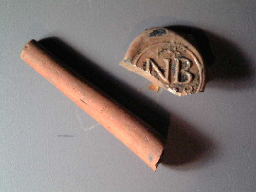
FAIRFIELD UPDATE 2. I've avoided writing these things for too long and this one is a big one so my apologies for the length and I'll try and make these more frequent and shorter in the future. Again the first chance I get to do these updates seems to be rain days. And today wasn't even that rainy. The weather has been fluctuating wildly between nasty and beautiful but the soil continues to be near perfect regardless of mother nature. So now I sit down for this second update wondering if we'll escape the wet season and still get all of our work done on time. The shovel test survey of the open fields is nearly complete with about 1200 done so far and another 300 left. We're up to about 85 a day now and getting more negatives than positives is finally a reality. We'll still have a 60-acre site, but at least we should be able to tell where some concentrations start and stop as we get further away from the main house. The most exciting find last month was the "NB" wine bottle seal. The reason I mention it again is that a local relic hunter has an identical one with "17_5" on it. This coincides with the dates we were imagining (either 1705 or 1715). It was found to the west of the house above the trash midden and we hope to have him come by so we can photograph it in the near future. Beyond that, the most exciting discoveries we've made shovel testing are the occasional features in the middle of the fields 1000 feet away from the ruins. These artifact concentrations are actually discernable and when linked with the subsurface features may show us our slave quarters and other outbuildings. The brush around the ruins is slowly disappearing. We've cleared everything down to the surface, leaving the occasional stump and sapling to remove, along with leaves and dead logs. We are planning to clear the remaining debris by the end of the month and then take on a close-interval contour survey of the area. Bruce Bevin of Geosight conducted a geophysical survey of approximately 6-acres surrounding the main house ruins and in select areas throughout the fields. The survey took 6 days and included the use of ground penetrating radar, a magnetic detector, and soil resistivity meter. The results of the survey were outstanding. He identified over 65 different features ranging from small trash pits to buried topsoil layers to large brick-filled cellars. This alone would keep us busy for multiple years and now our most difficult task is choosing where and which of these features to test over the next month. Mr. Bevin's survey was particularly helpful in further delineating our future open-area excavation, slated for initial work staring at the end of March. He identified two features beyond the 10 ft. x 10 ft. x 4 ft. brick-lined cellar and the hearth we located with shovel tests. This information, coupled with the shovel test concentration maps, should help us prioritize where we should start our excavations and what will provide us with the most information for our efforts. His work has proven well worth the monetary investment and I highly recommend his services as both a time saving measure and as a method for non-intrusive data collection. So in summary: We've identified the locations of no fewer than ten buildings and two prehistoric encampments dating from the Woodland prehistoric period (approx. 1000 B.C. to the 17th century) through to the 20th century. This last week we finished the first test unit within the ruin area and started a second concentrating on the bulkhead entrance to the house's ballroom wing. The first 5 ft. x 5 ft. unit revealed a foot and a half of brick rubble (from the destruction of the house) covering the early 20th-century ground surface. Laying on top of this buried surface was the complete remains of the lock plate to the bulkhead entrance door. Next to the lock plate was a complete mason jar lid with porcelain lining. At the center of this lining was the number "05", possibly dating the manufacture of this item to 1905. If that were true, we'd know that the ruin remained standing for at least eight years after the fire of 1897. The test unit excavation also revealed a handful of postholes associated with fences or scaffolding. Adjacent to the destroyed entrance to the cellar was the builder's trench for the bulkhead which contained a beautiful base fragment of polychrome Chinese export porcelain tea bowl. The remains of the bulkhead revealed that the architect Thomas Waterman was correct in 1932, assuming that this feature was a later addition to the building, possibly as late as the nineteenth century. Unfortunately, the lack of diagnostic material limits our interpretation of the feature's construction date. None of the bulkhead foundation (one-and-a-half-bricks-wide) was bonded with the ballroom foundation (three-bricks-wide) and clearly cut the main building's builder's trench (which unfortunately contained no diagnostic artifacts). Our intermittent document research has proven very fruitful. Changes in land value and building value fluctuated significantly at times and may be related to periods of renovation or destruction throughout the period 1820 to 1897 (see comments below). An auction or sale of the estate of the last Lewis Burwell of Fairfield mentions his vast collection of fine furniture, his much varied livestock and carriages, and his prized horse "Eclipse." This and other information from the Virginia Gazette is complementing the genealogical data we've received from across the country and the court records available at the county courthouse. Colonial Williamsburg's architectural files also included two photos of the main house we had not seen. The first was a view of the "back" side of the building, included in Waterman's book as a sketch. The picture was quite dark and was accurately portrayed in great detail in Waterman's book. The second view included a glimpse of the south gable wall, heretofore unseen by anyone we knew. It had a pair of windows on the first floor, none on the second, and two small windows flanking the chimney on the attic floor. The belt course continued around the side of the house, with a small decrease in thickness, but the water table did not. This last photo seems to be one of a set of photos, all taken with the same people in them. The most interesting discovery made through the historical research relates to the architectural evolution of the main house. References in 1844 and 1857 describe a manor house in much decay and ruin with significant sections recently taken down. This leaves the question of what was taken down and how does it compare to the building we see in photos from the 1880s? To this point most people had assumed that the original house was very similar to the house in the photographs, although the existence of other buildings and of an intended "evolution" in the houses design is referenced throughout the literature. We are now forced to reconsider how we envision the main house during its initial existence in the seventeenth and eighteenth centuries. While Thomas Waterman's drawing takes a significant step in that direction, he is not blessed with the archaeological perspective that we have access to and the means to investigate. Our research will be integral in this matter, forming the only reasonable method for finally deciphering the building "code" of this grand pre-Georgian period mansion. Over the next month we will hopefully complete
the shovel testing, open a few more test units around the ruin
and test some of the features that Bruce Bevin identified throughout
the property. We may also have some aerial photography done via
Blimp. Kim Robins of the Gloucester-Mathews Gazette-Journal is
preparing our first article and plans on continuing a series
of articles on our works over the coming months. Dave Brown, Assistant Director, |
|
|
| Copyright © Jane B. Goodsell, 2001 |