 (c) 1996-2024 Last Updated December 2023 |
 THIS COUNTY IS AVAILABLE FOR ADOPTION |
 |
|
(c) 1996-2024 Last Updated December 2023 |
THIS COUNTY IS AVAILABLE FOR ADOPTION |
|
| Interim State Coordinator:
Karen De Groote County Coordinator: Adoptable Contact the State Coordinator if you are interested in being the new Washington County Coordinator |
| Home |
Archives |
Bibliography |
Biographies |
Cemeteries | Census |
Cities/Towns |
History Maps | Military | Miscellaneous | Town Histories | Vital Records | Volunteer | What's New *Links will be activated when the pages have content. |
|
Washington County is one of several Vermont counties created from land ceded by the state of New York on January 15, 1777, when Vermont declared itself to be a distinct state from New York. The land originally was contested by Massachusetts, New Hampshire, and New Netherland, but it remained undelineated until July 20, 1764, when King George III established the boundary between New Hampshire and New York along the west bank of the Connecticut River, north of Massachusetts and south of the parallel of 45 degrees north latitude. New York assigned the land gained to Albany County. On March 12, 1772, Albany County was partitioned to create >Charlotte County and this situation remained until Vermont's independence from New York and Britain.
Washington County was originally established as Jefferson County in 1810 from parts of Caledonia County, Chittenden County, and Orange County and organized the following year.
In 1814 it was renamed to Washington County. The name change occurred after the Federalists took control of the Vermont Legislature from the Jeffersonians. Vermont which conducted significant trade with British Canada had suffered particularly by passage of the Embargo Act of 1807 during the Jefferson administration.
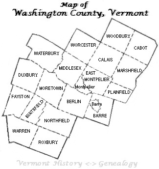
Surrounding counties: Addison | Caledonia | Chittenden | Lamoille | Orange
|
.png)
 Located in central Vermont, Washington County was incorporated in 1810 and organized in 1811, with Montpelier as the shire town (county seat).
It was called Jefferson County until 1814, when the name was changed to Washington.
Washington County was formed from portions of Addison, Orange, Caledonia and Chittenden counties as follows:
Montpelier, Plainfield, Calais and Marshfield were taken from Caledonia County.
Barre, Berlin, and Northfield were taken from Orange County.
Stowe, Duxbury, Fayston, Waitsfield, Waterbury, Moretown, Middlesex, and Worcester were taken from Chittenden.
Additional towns were later added to Washington County - including Roxbury (taken from Orange County in 1820), Elmore (taken from Orleans County in 1821),
Warren (taken from Addison County in 1829), Woodbury (taken from Caledonia County in 1835) and Cabot (taken from Caledonia County in 1855).
Located in central Vermont, Washington County was incorporated in 1810 and organized in 1811, with Montpelier as the shire town (county seat).
It was called Jefferson County until 1814, when the name was changed to Washington.
Washington County was formed from portions of Addison, Orange, Caledonia and Chittenden counties as follows:
Montpelier, Plainfield, Calais and Marshfield were taken from Caledonia County.
Barre, Berlin, and Northfield were taken from Orange County.
Stowe, Duxbury, Fayston, Waitsfield, Waterbury, Moretown, Middlesex, and Worcester were taken from Chittenden.
Additional towns were later added to Washington County - including Roxbury (taken from Orange County in 1820), Elmore (taken from Orleans County in 1821),
Warren (taken from Addison County in 1829), Woodbury (taken from Caledonia County in 1835) and Cabot (taken from Caledonia County in 1855).
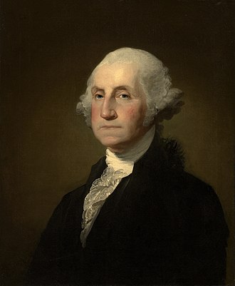 Named after George Washington, its county seat is the city of Montpelier (the least populous state capital in the United States) and the most populous municipality is
the city of Barre. ---
Named after George Washington, its county seat is the city of Montpelier (the least populous state capital in the United States) and the most populous municipality is
the city of Barre. ---