
![]()

a Proud part of USGenWeb ®

Jesse Pugh Jr. - Land Grant - 1789
Submitted by Clara Lawver
386
Jesse PUGH jr
267 Acres
Frederick
Exd
Beverley RANDOLPH Esquire Governor of the Commonwealth of Virginia
to all to whom these presents shall come. Greeting Know ye that by
virtue
of a warrant Issued from the late Lord Proprietors Office of
the Northern Neck
and in Consideration of the ancient Composition of
one pound ten Shillings
Sterling paid by Jesse PUGH jun. into the
Treasury of this Commonwealth
There is granted by the said
Commonwealth unto the said Jesse PUGH Junr.
a Certain Tract or parcel
of Land Containing two hundred and Sixty Seven
Acres by Survey
bearing Date the Twenty seventh day of September one
Thousand Seven
hundred and Eighty Eight. Lying & being in the County
of Frederick
adjoining the Land of James LAURANCE son of John LAURANCE
Decd. on
Hog Creek and Bounded as followeth To wit Beginning at a white
oak
and Hickory Corner to the Land of James LAURANCE, (formerly John
LAURANCE and running thence with his line reversed' South forty nine and
three quarters Degrees West one hundred and ninetysix poles Crossing a
branch several times
387
Times to a pine on a hill said
LAURANCES Corner thence along said LAURANCES line
reversed North
thirtyfour and three quarter Degrees West fortyfive poles to two white
oaks
Corner to John WHITE, thence along WHITE's line, South
twentyfive and three
Quarter Degrees West Crossing the Branch
eightytwo poles to a large white oak ~
Stump in a valley in said
WHITE's line & Corner to CLEAVER South seventy
four Degrees East
sixtysix poles to a white oak on the South side of a hill thence
Down
the hill South forty Degrees East thirtyfour poles to a Hickory on
CLEAVERS
line thence along it South sixtyone Degrees East twentyeight
poles Crossing Hog
Creek to a pine on the side of a hill CLEAVERS
Corner & the Course Continued
in all forty two poles to three pines
thence North forty Degrees East thirty
four poles to two pines on a
hill, thence North sixty Degrees East one hun-
dred and seventyeight
poles to two Chesnut oaks on a high hill thence
North forty degrees
East one hundred poles to a white oak and Spanish
oak on the North
Westside of a hill in the line of said James LAURANCE
thence North
twelve Degrees West sixtysix poles to a Spanish oak on the
side of a
hill thence, South eightyfour and one quarter Degrees West one
hundred and fifty poles to the beginning with its appurtenances to have
and to
hold the said tract or parcel of land, with its appurtenances
to the said
Jesse PUGH junr. and his heirs for ever In witness
whereof the said)
Beverly RANDOLPH Esquire Governor of the
Commonwealth of Virginia
hath hereunto set his hand and caused the
Lesse Seal of the said Com-
monwealth to be affixed at Richmond on
the second day of April in
the year of our Lord one thousand seven
hundred and eightynine
and of the Commonwealth the thirteenth ~~
B. Randolph

Jesse Pugh Jr. - Land Survey - 1789
Submitted by Clara Lawver
455
Jesse PUGH junr.
267 Acres
Frederick County
Recd. 30th Septemr. 88
Grant (Issued?) 2d.
April 1789
Examd.

Frederick County Sct. By Virtue of a Warrant from the Office of the
late Proprietor of the Northern neck N 1380. Dated the 16" day
of
January 1789 I have Surveyed for Jesse PUGH Junr. the following
tract
of Land in Frederick COunty Aforesaid. Adjoining the lands
of James
LAURENCE son of John LAURENCE dec'd on Hog creek which
is bounded as
follows. Beginning at a white oak and hickory
corner to the land of
James LAURENCE (formerly John LAWRENCE and
running thence with his
line reversed S 49 3/4 degr. W 196 poles crossing
a branch several
times to a pine on a hill said LAURENCES corner thence
along said
LAURENCES line again reversed N 34 3/4 ds. W 45 poles to two
white
oaks corner to John WHITE thence along WHITES line South
25 3/4 degs.
W (crossing the branch) 82 poles to a large white oak
stump in a
Valley in said WHITES line and corner to CLEAVER
thence S 74 d. E 66
poles to a white oak on the South side of a hill
thence down the hill
S 40 degrees E 34 poles to a hickory on CLEAVES line
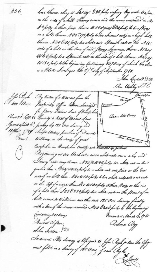
456
line thence along it S 61 degs. E 28 poles crossing Hog creek to a pine
on the side of a hill CLEAVERS corner and the course continued in all
42 poles to three pines thence N 40 degrees E 34 poles to two Pines
on a hill thence N 60 E 178 Poles to two chesnut oaks on a high hill
thence N 40 E 100 poles to a white a Spanish oak on the N W
side of a
hill in the line of said James LAURENCE thence N 12 degs.
W 66 poles
to Spanish oak on the side of a hill thence S 84 1/4 dgs.
W 130 poles
to the beginning Containing 267 Acres of which the above
is a Plott
Surveyed the 27th day of September 1788.
John Cordell D S F C
Ben Ashby S F C

If you have questions, contributions, or problems with this site, email:
Coordinator - Rebecca Maloney
State Coordinator: Jeff Kemp
Asst. State Coordinators:
If you have questions or problems with this site, email the County Coordinator. Please to not ask for specfic research on your family. I am unable to do your personal research.
![]()