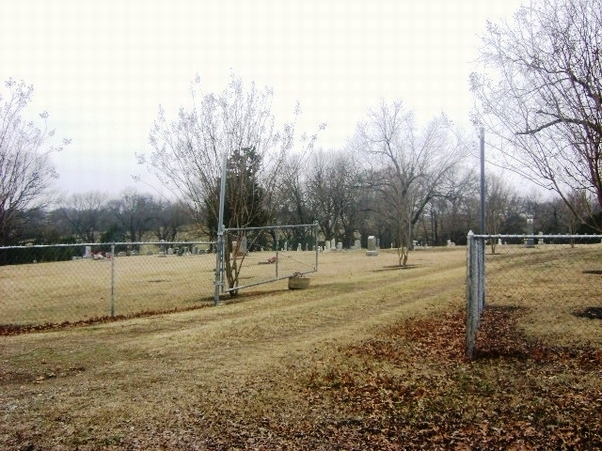
  Located east Sherman, take Hwy 11 to Camp-Ground Road and turn left. GPS Coordinates: Latitude: 33.5608, Longitude: -96.50691 Cedar Cemetery ca 1848 - 1969 The limited information of the history of Cedar Cemetery comes from personal interviews, early land titles, a few early historical papers, newspaper clippings, names and dates from Cedar's Memorial Rocks. The Cedar Church's early interment records were destroyed in 1960 when a tornado demolished the building. Another lapse of identification was caused by the disintegration of all stones quarried in some local areas. Many such tombstones erected before the close of the Civil War have been worn away by time. Pre-Civil War burial grounds in the Cedar community: Burt Snapp's farm in West Cedar - one burial Harris Family Cemetery located about 300 yards from the Snapp farm - as many as twenty King Family burial plot located southeast of Dr. King's home in a cotton field (now a pasture) is less than a mile away. It is not recorded as to why Cedar was a public burial yard. Whether penniless, destitute, large land owner, passing transient - anyone could be buried in a 'free' lot. Cedar is situated in Grayson County, Texas, lying on a high bluff located on the southside, and overlooking the waters of Big Cedar Creek, a tributary of Choctaw Bayou. The cemetary site lays astride the eastlin of the original Ignacio Trebeno survey (Vol. A, Page 348, 1848) and the west line of R. M. Williamson survey (Vol. 187, page 110, 1847). A factual documentation of the cemetery is scarce. It is often referred to as a 'graveyard' and as a landmark in land title transfers, in Vol. 121, page 378; Vol. 31, page 574, etc. To date, no documentation can be found that either side of this original survey line has ever been plotted, charted, mapped, deeded or given as a cemetery. Some graves already existed here, on, or before, the original survey lines were established in 1847-1848. Originally a spur of the old "Watershed Trail", also known as the "Divide Ridge", was used by the B. M. Carr family to go to church at Cedar in early-times. It is still in use today as the main road between Hwy 1281 on the south and Hwy 691 on the north. While still a part of Fannin County, white settleres were known to be in the area as early as January 1838 when a Bounty Warrant No. 1891 was issued by Barnard E. Bee, Secretary of War, to Lewis Ham, assignee of William Cox (Vol 179, pg 140). It was then sold to Rene Allred in 1844 who became the first land-owner in the Cedar Community, Through subsequent chain transfer to R. A. King, Dr. R. D. King and his brother, A. P. King, who were trustees of the first organized school. This particular spot is first mentioned as a cemetery in the field notes in Vol. 107,page 506 in 1893 as an "already established" landmark. The burying ground has been a respected cemetery for over one hundred years. No one has ever made a claim, under a tax-deed, for a title. It is not known who the first, or who was among the first buried here. The first 'known' grave was of the victim of marauding Indians. Gertrude Mead was three years old when her parents found her. She had been scalped by Indians (1848). Mr. and Mrs. Tom Mead were so discouraged at this tragedy, they returned to Virginia. When their cousins, the Mrs. Carrie Mead Martin family, moved here, the Meade's would send money to care for the grave of their daughter. Another early identified grave was of an unknown slave (1860). Members of the community saw vultures circulating over a clump of trees. They found the body of a slave whom they assumed had run away from his owner and met with unfriendly Indians known to be in the area. His body was wraped in a quilt and buried in the Cedar Graveyard. McKelvey Fogle (1799 - 1865 ), an early settler brought his motherless family to this area in 1854, paid cash to Stephen Jones for his plantation which included the west-portion of the graveyard. His grave site has never been identified. There are four generations of McKelvey Fogle descendants buried at Cedar Cemetery. Another lost burial is that of Mrs. Sarah Wallace, a charter member of the first church, and her husband, S. S. Wallace. Sarah Wallace was a cousin of B. M. Carr. In the beginnng permanent stones were not available with most burials marked by a bois d'arc slab or post with hand-carved initials and dates. Others were marked by the planting of a cedar tree. During the post-war years, a heavy over-growth of brush and native grasees would occasionally be buried over. Wood markers burned and cedar trees died. Lee Simmons began his "clean up cemeteries campaign". Funds were donated for the purchase of equipment. Stumps were removed. Bois d'arc stobs were replaced with concrete building blocks to facilitate mowing. Soon after, the Cedar Cemeterary Association was organized with Mrs. William Burk and Oscar Wetzel.  Burials    Historical Marker Cemetery Index Susan Hawkins © 2024 If you find any of Grayson CountyTXGenWeb links inoperable, please send me a message. |