|
SPRINGS
Herald Democrat Early-day travelers passing through Grayson County on horseback, in wagons or by stagecoach could take their choice of locations to stop for a refreshing drink of cool spring water to wash away a little trail dust. A few years ago a writer named Gunnar Brune, who lived in Arlington, published Volume I of “Springs of Texas,” a detailed study of the springs located in three-fourths of Texas, including Grayson County. Twenty-two springs are pinpointed and discussed in the Grayson County segment of the 566 page book. While Brune says his book primarily is for reference work, it makes good reading for persons interested not only in Grayson County springs, but geology, hydrology, archeology, history and ecology in Texas. Brune discusses each spring and events concerning each. In Grayson County he said the springs are mostly in the northeast portion, flowing primarily from the Woodbine sand, Austin chalk and river terrace sand and gravel. Indians, especially the Tonkawas, and early Americans camped along the Red River and its tributaries for many years where the springs were in abundance. Later the Comanches and Wichitas chose the site for their homes. In the early 1800s, before they were forced out by settlers, other tribes lived at the springs. These included the Delawares in the Northwest part of the county near what is remembered today as Delaware Bend; the Shawnees at the mouth of Shawnee Creek north of Denison; and the Choctaws, Creeks, Chickasaws and Cherokees. Numerous springs were inundated by the waters of Lake Texoma when it was built. One of these was Sand Springs at Coffee’s Trading Post on Preston Peninsula, which was in full operation in 1839. At least two springs are located in or near Sherman. One, Odneal or Big Springs, is near the intersection of Odneal and Branch streets there, according to Brune. In 1858 the Butterfield Overland stage made a stop at this spring as well as at Sand Spring near where Denison later was established. Sand Spring near Waterloo Lake was a watering place for California bound gold seekers, stagecoaches and cattle drovers. One spring is located near the National Guard Armory where the railroad trestle once stood. As recent as the late 1940s residents filled jugs with the cool spring water at the spring. Other sand springs still feed into Waterloo Lake. Post Oak Springs northwest of Sherman gave rise to Post Oak Creek there. Brune said that Lucas and Hall’s “A History of Grayson County Texas,” (1936) said that the Indians had a camp at Post Oak Springs. North of Sadler are Basin Springs and northwest of Pottsboro are Brogdon Springs, where a historical marker relates how a regiment in Ross’ Texas Brigade was organized there in 1861. Near that site are Stout Springs and Dripping Springs, where the water seeps from cliffs of Woodbine sandstone covered with fern, cress and moss. Cooke Springs, southwest of Denison, and Moss Springs, where Micajah Davis built his log cabin in 1837, are not far from Sand Springs. Miller Springs are located at the Verna Blood home, where Indians occupied the area before J.K. Miller built a cabin in 1852. There are Tanyard Springs between Denison and Sherman at Woodlake, although in 1976 when Brune did his research on the area, there was very little spring flow. A second Dripping Springs are just north of the Dripping Springs Cemetery between Denison and Sherman. At Carpenter’s Bluff, east of Denison, are Carpenter Springs, which were popular with persons crossing Red River on the ferry that once operated there. Everhart Springs are located northwest of Whitewright, and Clear Springs are north of Tom Bean. This was a popular spot in early days for revival meetings among the cedar trees, where the fresh springs flowed. Cold Springs are east-southeast of Van Alstyne. Brune said fish gather round the springs in the lake, which now covers the springs, indicating that they still flow. McKinstry Springs are located southwest of Sherman, and Copperas Springs are south of Tioga, as are Pierce Springs and Tiogo Springs, a popular health spa in the 1880s. Brune takes a “wet” subject and makes it interesting with research he did on each of the thousands of springs around this segment of Texas. He includes chemical analyses of spring waters and even maps of location of springs and seeps, hot and warm springs, mineral springs, archaeological features found near springs, 15th, 16th, 17th and 18th century trails and springs that served them, and a generalized map of spring aquifers. Hours upon hour of research was done by Brune to compile his book. The Texas Historical Commission furnished important historical and archaeological information on many of the springs. He had also searched out maps, talked to countless individuals, and searched every nook and cranny where the information might be hiding. Keep in mind that this book was written a number of years ago and some of the springs discussed may not be producing at this time. Twenty-two springs are located in mostly in the northwest portion of Grayson County. Numerous springs were inundated by the waters of Lake Texoma when it was built. One of these was Sand Springs at Coffee's Trading Post on Preston Peninsula, which was in full operation in 1829. (Brune, Gunnar. Springs of Texas. c1981.)  One spring is located under the railroad trestle southwest of the National Guard Amory in Denison, and as recently as the last 40 years, residents filled jugs with cool spring water. Basin Springs Located about 3 miles north of Sadler on Edith Funk's farm Brogdon
Springs Carpenter
Springs Cedar
Springs Located north of Tom Bean and then north of Cedar Cemetery A group of pioneers settled around these springs in 1848. It was a popular spot in the early days for revival meetings among the cedar trees where the fresh springs flowed. Clear Springs Located north of Tom Bean was a popular spot in early days for revival meetings among the cedar trees, where the fresh springs flowed. Cold Springs Located east-southeast of Van Alstyne Fish gathered around the springs in the lake which now covers the spring The presence of the lake indicates that the springs still flow and the lake is spring-fed. Cooke Springs Located southwest of Denison near Sand Springs. Located near the log cabin home of Robert Atchinson where the first court was held in Grayson County - 1846 Copperas Springs Located south of Tioga This was a popular spot for health spas in the 1880s Dripping Springs #1 Located north of Brogdon Springs Water seeps from cliffs of Woodbine sandstone covered with fern, cress and moss. It is reported that horse thieves were hung from a walnut tree here. Dripping Springs #2 Located just north of the Dripping Springs Cemetery between Denison and Sherman and northeast of Sherman. The first Baptist church in the county was established here. Everhart Springs Located northwest of Whitewright Flowing Wells Martin Springs Located due west of Pottsboro McKinstry Springs Located southwest of Sherman Miller Springs Located at 1901 W. Walker St., Denison, Texas, at the W.R. Blood home. The site was occupied by Indians before J. K. Miller built a cabin here in 1852. This spring supplied his household, neighbors and travelers on nearby Ferry Rd. A log cabin was built in 1866 and is still preserved by the current occupants - 1976. Stagecoaches stopped here in the 1850's. Mineral Springs Moss Spring Located southwest of Denison and near Sand Springs Where Micajah Davis built his log cabin in 1837 Odneal (Big Springs) Located near the intersection of Odneal and Branch streets in Sherman In 1848 the Butterfield Overland Stage made a stop at this spring as well as at Sand Spring near where Denison later was established. Pierce Springs Located south of Tioga This was a popular spot for health spas in the 1880s. Post Oak Springs Located about 3 miles northwest of Sherman, gave rise to Post Oak Creek It has been written that Indians used to camp at Post Oak Spring. Sand Spring, which fed into Waterloo Lake Located at the mouth of Little Mineral Creek near Holland Coffee's trading house - 1839 A watering place for California-bound gold seekers, stagecoaches and cattle drovers in the mid 1880s. Spring Creek A cattle trail known as the Sedalia, Missouri Trail had been beaten out by herds of longhorn cattle and the cowboys who drove them near Spring Creek. The men with their herds made Spring Creek their overight stopping place. Soon Jim Swindle and other men of vision began business nearby. When a hotel, a livery stable, a blacksmith shop, a saloon, a grocery store and post office had been established, the little village was called Toadsuck. It flourished there until the completion of the Missouri Kansas and Texas and the Texas and Pacific Railroads laid their tracks through the area, about one fourth mile west of Toadsuck, which later became the town of Collinsville. Stout Springs Located east of the site of Brogdon Springs; both are located northeast of Pottsboro Water seeps from cliffs of Woodbine sandstone covered with fern, cress and moss. A pot of coins is said to have been found at the springs. Downstream is a waterfall which includes the flow of Brogdon Springs also. Tanyard Springs Located midway between Denison and Sherman at Woodlake, on the abandoned right of way of the Sherman and Denison Railroad. In 1901, the railroad built Woodlake Park to promote travel. The first Texas interurban line carried patrons to the Recreational Park. In 1976 there was very little spring flow. Source: Springs Were Important In Early History of Grayson County by Judge R. C. Vaughan; edited by Jerry B. Lincecum 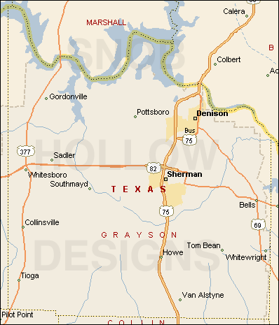 Top Springs in Grayson County, Texas Waterways Susan Hawkins © 2024 If you find any of Grayson CountyTXGenWeb links inoperable, please send me a message. |
