 Denison Dam Spillway The floods were constantly washing out bridges in the old days.
The danger of flood finally led the Federal Government to construct the Denison Dam. When that project was authorized in 1939, army engineers considered the great flood of 1908 as the arch typical emergency that must be counteracted by the dam. Lucius D. Clay, later to be distinguished as a Lieutenant General in World War II, but at that time one of the army engineers at work on the project, predicted that such a flood as that of 1908 would recur once in every hundred years. Since so great emergency was expected so rarely, the recreational facilities at Lake Texoma were planned to border the normal level of the lake. This mean that in an abnormally dry spell picnic areas, concession stands and the like would be a good distance back from the water, but in more normal times they would be convenient to the beaches. And thus things worked out. mostly. But the weather began to ignore the norm in 1956. As drouth settled over the upper reaches of the Red, the water in the lake began to go down and down. Dry beaches widened and looked as though the loose sand had been scuffed up by milling cattle rather than bathers and holiday parties. As the lake subsided, swimmers were sometimes surprised to run into stumps and barbed wire fences. People shook their heads and said, "It's low." Indeed it was low. On March 19, 1957 the water stood at 599.97 feet, more than forty feet below the level of the spillway. The world's largest "earthen-filled folled" dam was still holding back a lot of water, but the lake looked puny and shrunken in its ugly brown borders. 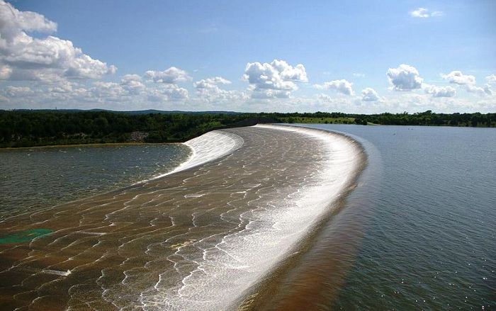 Then it began to rain. Two week later the level of the water had climbed six feet. The rains kept on, and the water continued to collect behind the dam. Still it did not seem that the lake could even approach its normal level by the time summer came. In the third week of April, however, it became evident that general rains over the watershed were making a conspicuous difference in the lake. The level rose five inches on April 21. On April 23 it rose ten inches. On April 28 the level reached 617 feet, the top of the power pool. But the water continued to rise, and on May 1 the flood gates were opened. Very soon residents of the lower valley began to complain that they were already troubled by flooding and that the additional water let out of Texoma through the flood gates would ruin them. Political pressure brought a decrease in the amount of water released. While the flood gates were open, fishing below the dam proved to be sensational. The banks of the river were lined with anglers pulling fish from the racing waters with a frequency which belied the sport of the thing. contributor of information and photograph - unknown Lake Texoma Spillway Overflows, 1957 Lake Texoma Spillway Overflows, 1990 Lake Texoma Spillway Overflows, 2007 Lake Texoma Spillway Overflows, 2015  Denison Dam Susan Hawkins © 2024 If you find any of Grayson CountyTXGenWeb links inoperable, please send me a message. |