 The Trails of our Past 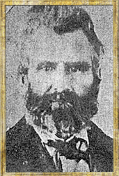 Daniel Montague Trails of Our Past Expedition: Grayson County Montague Grove January 17th 2016 - Today I opened a cold case. I
began to look at some information that I had uncovered in 2015, but had not yet
had time to give it the attention that it deserved. For years it has been said
that the last Indian battle in Grayson County took place near what is now,
Howe. It has also been said that Howe was originally called "Summit" and was
moved to its current location at a later date. While it may have been called
Summit, the relocation of the town is debatable, however that is a story for
another time. So the last Indian battle took place near Howe? Well, in
short, the answer to this question is "No." That’s right, the last Indian battle
did not take place near Howe. So where exactly did this myth arise from? Well
to understand that, let’s start way back in the beginning with the battle
itself. In 1843, prior to Texas’ statehood, a band of Indians were
moving about Red River country stealing from settlers and making life overall
rather difficult for them. One night, the group of natives bedded down and camped
in a grove of trees just south of the Sherman square. Fannin County surveyor
and early pioneer, Daniel Montague, with a group of men, led an attack on the
unsuspecting group of Indians and killed almost every one of them, the number
having said to be about 16. So great was the amount of blood spilled that it
was said the flowers the next year were bright red. This grove of trees came to
be known as, Montague Grove. In the book, Texas: Land of Legend and Lore, by Bill Cannon,
the author states the following: “After seventy-odd years of traversing the
highways and back roads of the Lone Star State and witnessing nature’s
splendor, especially her palette of wildflowers that perennially blanket the
fields and hills of Texas each year, I am confident the rich red color of what
is known as Montague’s Grove near the Grayson County city of Sherman is
nature’s perennial display of Indian paint brushes and Indian blankets rather
that a phenomenon resulting from a skirmish with a band of Indians that
happened in the mid-nineteenth century.” So where did Howe come into play? In Mrs. Lucas and Mrs.
Hall’s, respectively, book on Grayson County History, published in 1936, it is
said that the battle took place in this grove just south of Sherman near the
Old Howe road. It would appear that this was built upon and eventually it was
just simply stated that the battle took place near Howe, rather than the old
Howe rd. Perhaps the best account of this mysterious grove of trees
comes to us in, The Galveston Daily News, published February 06, 1874. In their
“Grayson County” section, the following is written from, “The Courier” of
Sherman. “It is not generally known by the newer part of our citizens that
Sherman possesses a spot sacred to the commemoration of the early struggles of
Texas. But such is the case. About two miles south of the square on the high
prairie, just to the right of the Mantua road, stands a grove of trees covering
several acres, and plainly to be seen from the northern end of the city. This
grove was the scene of a fierce Indian fight in the days of the Republic, some
thirty years ago. The Indians, true to their instinct, had raided down upon the
frontier-then several counties east of here- and stole all the horses they
could drive off. There was no “government policy” to interfere, and a party
settlers, headed by Daniel Montague, followed on their trail and overtook them
about dusk one evening at said grove, where the Indians were camped. Waiting
until dark, they came down upon the unsuspecting Indians in a style that only
frontiersmen can, killed quite a number of them, re-captured their stock, and
learned the Indians a lesson that they remembered for years. Since then the
place has been known as “Montague Grove.” January 24th 2016 - I went to Sherman today and took
my time as I came upon the south end of town. Glancing around I have these
thoughts in regards to the location of the mysterious “Montague Grove.” It
would appear that the grove was located just north of where FM 1417 intersects
highway 75. I would surmise that the grove could be located as far west as
where the golf course is now located and extend east to where the Camelot
Apartments are located and back north toward where the RV park is. The grove
could also continue to extend east back behind Constitution Village. This area
is all roughly 2 miles south of the Sherman Square. I have not been able to find any information thus far giving
a better description of the grove than the ones mentioned before. I will keep
my eyes and ears open and should more information become available I will
surely pass it along to you, the readers. When I created Expedition: Grayson County, I was bound and
determined to be different than those history television shows. You know, the
ones who are forever searching for the next greatest discovery and alas they
are inches away from a revelation when some detour prevents them from revealing
the lost history in which they seek. Unfortunately, for this story anyway, the
same fate plagues Montague Grove. Perhaps the answer shall have to wait until spring. When little red Indian Paintbrushes first stretch their stems up from the black lands of Grayson County. Flowers that surely have a story to tell and perhaps even hide beneath their shallow roots deep secrets of a battle from long ago. So while driving through Sherman’s south end and should you happen to stumble upon a field a red, know that the color may be more than the simple genetics of a flower. For it is said that these sacred flowers shine brightly for all to see as a constant reminder of the bloodshed that bestowed itself on this peaceful grove those many years ago. 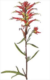 Trails of Our Past Susan Hawkins © 2024 If you find any of Grayson County TXGenWeb links inoperable, please send me a message. |