 The Trails of our Past Expedition Grayson
County McKinney Homestead By: Dusty Williams February 9th, 2016 It’s late and I haven’t much to say, but I have spent the
past several hours looking at the old McKinney family land. This is the Collin
McKinney family who were early settlers to the Grayson-Collin County line area.
I’ve dabbled into bits of this before, but have never fully engulfed myself
into solving the many mysteries that this family has left behind in regards to
their homesteads. I’ve been going through old tax records, learning which
abstracts of land this family owned and comparing them with modern day maps. My
findings thus far indicate that the majority of this family lived along what is
now highway 5 between Van Alstyne and Anna. With the rapid residential
development that is currently taking place here, I will need to quickly
establish the location of these homesteads. For starters, I have definitively proven that the Collin
McKinney homestead was at the following location: Leaving Van Alstyne and
traveling south on highway 5 and crossing into Collin County, Texas. Turn east
onto county road 1106. County road 377 intersects county road 1106 on the
north. The Collin McKinney homestead boundaries begin here on the south side of
county road 1106. The west boundary line of the homestead continues due south
of where county road 377 intersects county road 1106. The west boundary
continues south until it intersects highway 5 as the highway makes a
south-easterly direction. The boundary line slightly crosses over highway 5 to
its south-west and then immediately turns east and back across highway 5, thus
creating the beginning of the south boundary line. The south boundary line
continues due east on the north side of county road 376, this road forming the
south boundary. The south boundary line ends when county road 376 turns to the
north. The now north moving county road 376 creates the east boundary for the
homestead, the homestead being on the west side of county road 376 at this
point. The east boundary continues north until turning west at which point the
name of the road is changed to county road 1106. The north boundary line is
created by the east-west direction of county road 1106, the homestead being on
the south side of this road. The north boundary line continues west until
reaching the point of beginning at the intersection of county road 377. The
property mentioned in this description is the R. Whitaker land survey. It also appears that Collin McKinney owned land out of the
S. Moore survey to the west of highway 5 and to the north of county road 371.
This adjoins the Whitaker survey on its southwest quadrant. He also owned land
out of the M. R. Roberts survey which adjoined the R. Whitaker survey to the
east. There is another S. Moore survey to the south of M. R. Roberts survey,
however it does not adjoin the Whitaker survey. February 10th, 2016 With 70 degree weather today, the kids and I took a drive. I
drove to the old Collin McKinney homestead and I am amazed at the amount of
development that is underway in that area. Coming from the north we turned east
onto county road 1106 which serves as the north boundary line for the Collin
McKinney homestead. The land to the north of this road belonged to William
Creager who married Collin’s niece, Bexey McKinney. On the south and on Collin
McKinney’s land there is a new subdivision going in, making it hard to
recognize the once country landscape. We turned south onto county road 426
which runs right through the middle of the old McKinney home place. When this
road intersects county road 376, Collin McKinney’s land ended, but the land of
his son, William C. McKinney included all of this area as we continued south
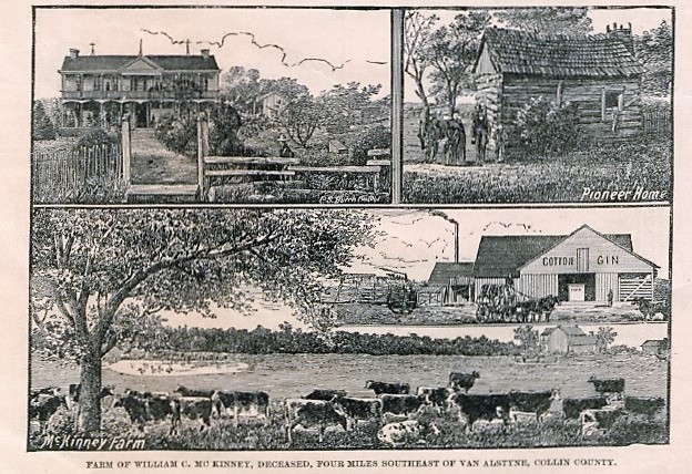
onto county road 427. The Hand-Book of Northern Texas, published in 1886 had this to say about the William C. McKinney farm. “The McKinney Farm of 700 acres, and the old homestead of Collin McKinney, in honor of whom both Collin County and its capital city were named. It lies four miles southeast of Van Alstyne, on the Texas Central Railway, is finely hedged, watered by springs and tanks, and has a pretty modern home, set in ample lawns and surrounded with evergreens, shrubs, fruits, a large cotton gin, good barns, sheds and other outbuildings. About 300 acres are usually in crop to cotton, corn, oats and wheat, all of which give a large average yield. This farm, which is one of the finest in the county, has been settled nearly forty years and is as productive as when it was new. They keep 100 cattle and forty horses and mules, and make the place pay a handsome revenue. Elder McKinney, who left behind him this valuable property and an honored name, died at the old farm in November, 1885, at the age of eighty. He was born in Kentucky in 1806, and in 1824 moved with his father’s family to Texas, settling near Texarkana, with no neighbors on the south nearer than 200 miles. He was married to Margaret Dooley in December, 1827, and settled at Elam’s Prairie, where he lived till 1831, when he moved to the Red River country, remaining there till 1834 when he took charge of his father’s farm while his father was in the convention that made Texas a Republic. In 1840 he was ordained an Elder in the Christian Church, and in 1847 removed with his father’s family to Collin County and settled on the homestead above described. He left a widow, five sons, two daughters, a good many grandchildren, and some great-grandchildren. “Uncle Billy” McKinney, as he was familiarly called, was a large-hearted, earnest Christian man, a devoted and zealous minister, a warm, generous and faithful friend, of kindly impulse and honest purpose; left the impression of a noble life on the social and religious world around him, and died serenely at a ripe old age, beloved and regretted by all.”
So as I stated, we left Collin’s homestead and ventured into
the homestead of William C. McKinney. Currently I have not found any remnants
of his home, although I was able to find a photo of it in the before mentioned
book. After crossing over county road 376 and heading south on county road 427,
the road took a southeasterly direction. Along this stretch and just before the
road straightened out into an east-west road, we observed two old barns on the
north side of this road. The GPS coordinates for these structures is: Lat.
33.370331 and Lon. -93.541089. Just down the road is the grave of Margaret E.
Kelly, a granddaughter of William C. McKinney. I am confident that these old
structures were a part of the William C. McKinney farm. According to old tax
records, William C. McKinney owned all of this land, as well as some land back
towards the west stretching on over to the west side of highway 5 and back
north toward county road 373. The house and the homestead were located in front
of the cemetery on the south side of county road 427 before it begins its
southeasterly stretch. Another farm of interest was the Pleasant View Farm. This
farm belonged to Josiah L. and Emily McKinney Kelly. Emily was the daughter of
William C. McKinney and the mother to little Margaret Kelly who is buried in
the grave mentioned before. The Hand-Book of Northern Texas said that the farm
was “a No. 1 body of land lying two miles south of Van Alstyne, in Collin
County. It is watered by springs and wells, embraces 140 acres of native
timber, fine orchards and fruit yards, and is further improved with eight
tenant houses, good fences, corrals, feed yards, etc., etc. Mr. Kelly grows 100
acres of wheat and oats, and large crops of corn and cotton, his corn averaging
fifty bushels, his oats sixty bushels, and his wheat twenty bushels per acre.
He keeps thirty cattle, forty pigs and a dozen horses, is a capital farmer, and
one of the ablest business men in the county, owns a model farm, has made every
dollar of his fine property since coming here in 1854, and is one of the
strong, level-headed, influential and honorable men of his region.” J. L. Kelly
also ran a grain house in Van Alstyne. I was fortunate in locating the original location of the
Pleasant View Farm. Through the Anna Historical Society I sent out a request as
I was searching for information on any of these properties. One of the replies
was from a descendant of Mr. and Mrs. Kelly who was actually born on the farm
and in the old house. In the 1970’s her parents had the home moved and
constructed a new home. The farm of Mr. and Mrs. Kelly was located at what is
now, 834 County Road 373 in Anna. The approximate GPS coordinates for the
Pleasant View Farm are: 33.386955, -96.570836. This farm was located in the old
town of Mantua. February 14th, 2016 I had quite the adventure yesterday. I met with Betty
Morriss, the president of the Anna Historical Society and we went to a few of
the old McKinney homesteads, including that of Collin McKinney. Our journey
begins heading south on highway 5 from Van Alstyne and turning east onto county
road 1106, again, this road creates the north boundary line for Collin
McKinney’s homestead. We turn south onto county road 426 and cross over
Sweetwater Creek. After crossing the
creek we turned into what once was an old driveway on the west side of the
road. Here, the John W. McKinney home was located at GPS coordinates 33.384210,
-96.544210. John was a grandson of Collin McKinney, he being a son of William
C. McKinney. John said that his grandfather’s old cabin was located due west of
his home. According to a 1935 map that I have found, there were three
structures lined up in an east-west line, the one to the farthest east and
closest to county road 426, being the home John W. McKinney. His home was torn
down in later years. The old cabin of Collin McKinney was moved to Finch Park
in McKinney in 1936, a year after John McKinney’s death, and later burned.
According to later maps and prior to the demolition of J. W. McKinney’s home,
the middle structure of the before mentioned three structures was removed, thus
indicating that it was the middle structure that was the log cabin of Collin
McKinney. According to a 1931 interview with John W. McKinney which is located
in the George P. Brown papers, J. W. McKinney said “arrive at the home of J. W.
McKinney, which is a large two story frame residence with many rooms above and
below and many out houses and barns and plenty farm machinery; go west 300
yards and you arrive at the residence of Collin McKinney in 1845. It stands
today (1931) exactly where it stood when first built, on the south side of a
ravine or branch which runs in a easterly direction into Mahar Branch, a fork
of Sister Grove Creek.” Although none of these homes are still standing here, we
were able to find some of the old barns that accompanied the McKinney
homestead. One rather large barn was located at GPS coordinates 33.384512,
-96.545160 and had a windmill just to its north along the creek. According to
the 1935 map, there was also a structure a little farther west along Sweetwater
Creek near where Dumas Dr. and Elam Dr. meet and a little to the south and
west. When Collin and his wife died in the early 1860’s, William C. McKinney
acquired this land that his father left behind and when his son, John W.
McKinney was of age, he acquired the land and establish his residence. Leaving this home site, we traveled south on county road
426. As we crossed over county road 376 we then entered into the William C.
McKinney homestead. The county road, now called 427, curves to the south east,
however we did not take the curve. We remained straight on an old dirt path
that traveled south. Here, and old two story house once stood which was a part
of the William C. McKinney farm. The house was located at GPS coordinates
33.371594, -96.544640. The house was described as having a long hall upstairs
with several bedrooms located off of the hallway. For that reason, some people
speculated that it may have served as a hotel of some kind for the stage…that
is, however, speculation. To the southeast of this house is a well and an old
barn still standing(33.370936, -96.544541), and just to the south of where this
house stood is a tombstone that belongs to Margaret E. Kelly…this being located
at GPS coordinates 33.370875, -96.544777. While this is the only stone still
standing, several people remember there being more tombstones in this cemetery
at earlier times. There was also an old iron gate that surrounded the sacred
place, however someone has come in a removed it. Perhaps the oldest relic found on this farm was a very large
barn with an adjoining barnyard fence that dates well back into the 19th
century. This was located at 33.371109, -96.545443. As nails were scarce at
this time in history, often times settlers would use wooden pegs to attach one
piece of wood to another. There were several of these wooden pegs still intact
and imbedded into the extremely large fence post that adjoined the barn. Upon
removing some of them we discovered that they had a black color on their
interior tip. Smelling this pegs revealed that they had been dipped into
creosote to keep them from rotting. I walked the width of this barn and it took
me 20 footsteps to reach one end to the other. Upon reaching the front of the
barn, I walked another 15 footsteps to the post that held up the covered pass
through in front of the barn, thus making the barn 35 of my size 9 footsteps
wide. I would estimate that the length of the barn was double this. Twenty feet away from this old barn and the old homestead of
William C. McKinney there were construction men working to ready the land for a
new subdivision. It will be but a matter of time before all relics of this
historic and influential farm are lost to time. At one time, people came from
miles around for the use of the McKinney family “mad stone.” This was an old
stone from Virginia that Mr. Milam purchased and it was believed to have
healing powers, especially for those who were bitten by rabid animals…but that,
my friends, is a story for another day. So there you have it. Three influential farms and ranches
whose proprietors played an important role in Texas’ younger days. The McKinney
family homesteads encompassed the entire area that was mentioned in this
article and consisted of much more land farther north and into Grayson County.
These three home places were gathering spots for many milestone events that
occurred in north Texas. And as is the case with many circumstances of our
area’s past, they are all but lost to time. Development is rapid, especially in
the area mentioned in this article. The grave of little Margaret Kelly was
practically destroyed and its future is still somewhat questionable. I
encourage you to get out and take a drive so that you might see some of this
important history before it is merely a tale recorded in a book. The locations of these homesteads have been proven through
19th century tax records, census records and firsthand accounts. Trails of Our Past Susan Hawkins © 2024 If you find any of Grayson County TXGenWeb links inoperable, please send me a message. |