

Hillsborough County
NHGenWeb

Primarily abstracted in 2002 by Ann Mensch from History of the Town of Wilton, Hillsborough County, New Hampshire, by Abiel Abbot Livermore and Sewall Putnam, Lowell, Mass.: Marden & Rowell Printers, 1888.
The first movement towards the settlement of Wilton was made in
1735. On the 19th of June of that year a petition was presented to the
General Court of Massachusetts by Samuel King and others for relief in
consideration "of their sufferings" in the expedition to Canada under
Sir William Phips in the year 1690. Agreeably to the old Roman method of
rewarding military services by colonizing the veterans, a committee was
chosen, consisting of Samuel Wells, Esq., Samuel Chandler and John
Hobson, to lay out a township of the contents of six miles square, west
of Narragansett, called Number Three, or Amherst, and also called
Souhegan West, and return a plat thereof to this Court within twelve
months for confirmation.
The following is a description of the
tract of land called Salem-Canada, as laid out in May, 1736, by order of
the authorities of Massachusetts Bay, and returned June 2, 1736:
"Beginning at a spruce tree and runs north by the Needle 2191 rods on
province land to a hemlock marked; then runs East 1558 perch on Province
land to a township adjoining to and lying north of Salem-Narragansett
No. 3; then turns and runs south on said township 640 rods to a township
granted to Jona Simpson and others; then turns and runs East on said
township 402 pole to a stake and stones; then runs south 1467 perch on
said Narrangansett town; then runs west 480 perch on Duxbury School Farm
to stake and heap of stones; then turns south 13 perch on said Farm to a
poplar; then runs west 1460 perch to the spruce first named."
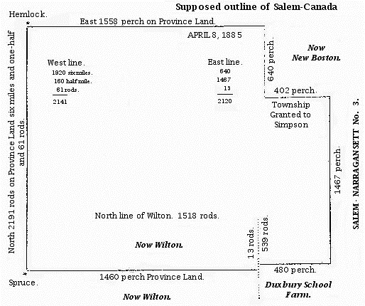
Map of Salem-Canada, Supposed
If we suppose the distance from Duxbury
School Farm to the spruce at the southwest corner of Salem-Canada (1460
rods) to be correct, that spruce must have been in what is now Wilton;
the north line of Wilton being 1518 rods, would leave the spruce 58 rods
east of the present west line of Wilton.
In the town clerk's
office at Lyndeborough was found a copy of the Salem-Canada grant, and
also a plan of the same, from which this is a copy.
The
distances, etc., of the several lines on this plan were put down the
same as they appeared on the plan at Lyndeborough. It may be seen that
there is a discrepancy on the west line of fifty rods between the
figures and the sum as written out, but it is the same in the
description.
The dotted lines on this plan do not represent any
lines on the plan at Lyndeborough, but represent the north line of
Wilton, and the east line as far as Lyndeborough runs south.
This
tract, including Lyndeborough and the north part of Wilton, received
then the name of Salem-Canada. The term "Canada" was obviously given on
account of the remembrance of the expedition to Canada. The prefix of
"Salem" was, perhaps, due to the fact that, in the early history of the
country, Essex County, Massachusetts, of which Salem was the shire town
or capital, was represented as extending back westward from the seaboard
to the Connecticut River, covering, of course, as may be seen by the
map, the territory now occupied by the towns of Lyndeborough and Wilton.
It has also been suggested that the signers of the petition to the
General Court for relief were probably residents of Salem and vicinity.
The town of Salem-Canada, six miles square, was to be divided into
sixty-three equal shares, one of which was to be for the first settled
minister, one for the ministry, and one for the school.
The
conditions of settlement were that on each share, within three years, a
good family should be settled; a house built eighteen feet square and
seven feet stud at least; that six acres of land should be cultivated;
that the inhabitants should settle a learned orthodox minister, and
build and finish a convenient meeting-house for the public worship of
God.
The grant of
Salem-Canada in 1735 by the Massachusetts General Court and the
settlements formed in it, were followed in 1749 by the grant of a new
township, from the proprietors holding under charter of John Tufton
Mason, to a company of purchasers, forty-six in number. Many of them
never resided on property, but afterwards sold their lands to settlers
coming in. These shares were drawn by lot. The deed conveying the land
was dated October 1, 1749, at Dunstable, and the lots were drawn on
October 16, 1749. The name first given to the new township, which
included on the north a part of Salem-Canada, was "Number Two."
The following conditions were prescribed by the proprietors to the
grantees:
1. Two lots of eighty acres each should be set apart to
encourage the building of mills.
2. One share of two hundred and
forty acres should be given to the first minister.
3. One share
should be set apart for the Christian ministry.
4. One share should
be given to schools.
5. The shareholders should make all roads.
6.
The original proprietors should be exempt from all taxes.
7. The
shareholders should settle and build houses on forty lots.
8. Each
settler should pay $13.33 to aid to building up the town.
9. Those
not fulfilling the conditions, except in case of an Indian war, were to
forfeit their shares.
10. White pine trees were to be reserved for
the British navy.
This new township, which, with the new territory on the south, included on the north a portion of "Salem-Canada," received the name of "Number Two," as stated above. This name was continued until 1762, thirteen years, as the title of Salem-Canada had been for fourteen years, viz.: from 1735 to 1749. "Number One" was Mason, "Number Two," Wilton.
Extract from the deed making the grant of the township of Wilton by the Masonian Proprietors:
PROVINCE OF NEW HAMPSHIRE. [pp. 32-34]
Pursuant to the Power and Authority
granted and vested in me by the Proprietors of Lands purchased of John
Tufton Mason Esq. in the Province of New Hampshire by their vote Passed
at their meeting held at Portsmouth in said Province the 16th day of
June 1749 I do by these presents on the terms and conditions hereafter
expressed give and grant unto Thomas READ, Esq., Robert FLETCHER, Jun.,
Joseph BLANCHARD, Jun., Oliver COLEBURN, Oliver FARWELL, Jno. USHER,
THomas SPAULDING, John LOVEWELL, Jun., John VARNUM, William FOSTER, the
Rev. Mr. Thomas PARKER, Josiah BUTTERFIELD, Anthony EMORY, Benjamin
PARKER Jun., Nehemiah ABBOT, Samuel GREELE, Benjn. FARWELL, Oliver
WHITING, Jos. RICHARDSON, Benjn. FARLEY, Jno. KENDALL, Abraham KENDALL,
David ADAMS, Joseph FRENCH, Eleazer BLANCHARD, Zacheus LOVEWELL, Samuel
FARLEY, William CUMMINGS, Jona. POWERS, Samuel CUMMINGS, Archalaus DALE,
Jacob PUTNAM, Nathaniel PUTNAM, John DALE, Stephen HERRYMAN, John SHEAD
and Ephraim PUTNAM, all the right title and property of the Grantors
aforesaid of in and to all that part of a township or tract of land in
the Province of New Hampshire aforesaid containing five miles square
Lying on the branches of Souhegan river between Peterborough and Munson
bounded as follows. Beginning at the Southwest corner of the premises at
a white pine tree, which is the Northwest corner of the Township No. 1
and runs from thence north five miles to a white ash marked, from thence
east five miles to a stake and stones, from thence south five miles to a
Chestnut tree marked, from thence west five miles to the white pine tree
first mentioned which said Township is laid out, drawn for and the lotts
ascertained to each grantee respectively also two lotts for
encouragement for building Mills and three shares for public uses viz.
one for the first settled Minister, one for the Ministry and one for the
school.
In witness whereof I the Subscriber Joseph Blanchard of
Dunstable have hereunto set my hand and seal this first day of October
1749. JOSEPH BLANCHARD.
| SCHEDULE OF LOTS DRAWN BY THE GRANTEES | |||||||
| GRANTEES | Draught | Lot No. | Range | Lot No. | Range | Lot No. | Range |
| Minister | 6 | 12 | 7 | 17 | 10 | 20 | 4 |
| Ministry | 28 | 17 | 2 | 8 | 8 | 9 | 1 |
| Mill lots | 67 | 13 | 4 | 14 | 4 | .. | .. |
| School lots | 42 | 12 | 9 | 10 | 9 | 10 | 1 |
| Nehemiah ABBOT | 43 | 13 | 9 | 3 | 1 | 16 | 1 |
| David ADAMS | 56 | 17 | 1 | .. | .. | .. | .. |
| Eleazer BLANCHARD | 60 | 11 | 6 | 1 | 9 | 1 | 6 |
| Joseph BLANCHARD, Jr. | 2 | 8 | 4 | 8 | 3 | 20 | 2 |
| Joseph BLODGETT | 17 | 5 | 5 | 5 | 6 | 3 | 7 |
| Joseph BLODGETT | 51 | 16 | 7 | 13 | 5 | .. | .. |
| Josiah BUTTERFIELD | 35 | 17 | 7 | 14 | 2 | 17 | 6 |
| Ezra CARPENTER | 22 | 12 | 6 | 17 | 3 | 15 | 1 |
| Oliver COLBURN | 3 | 10 | 6 | 1 | 10 | 16 | 3 |
| John COMBS | 16 | 4 | 3 | 8 | 2 | 9 | 2 |
| Jonathan CUMMINGS | 23 | 3 | 2 | 4 | 2 | 11 | 3 |
| Samuel CUMMINGS | 66 | 6 | 2 | 5 | 2 | 6 | 1 |
| William CUMMINGS | 64 | 2 | 2 | 4 | 1 | 5 | 1 |
| Peter POWERS & A. DALE | 27 | 7 | 8 | 7 | 7 | 7 | 1 |
| Archalaus DALE | 71 | 16 | 6 | .. | .. | .. | .. |
| John DALE | 68 | 16 | 2 | 21 | 2 | .. | .. |
| Anthony EMORY | 36 | 15 | 2 | 2 | 8 | 3 | 8 |
| Benjamin FARLEY | 50 | 19 | 8 | 18 | 6 | .. | .. |
| Samuel FARLEY | 63 | 20 | 9 | 11 | 7 | 11 | 9 |
| Benjamin FARWELL | 46 | 16 | 9 | 9 | 6 | 19 | 9 |
| Oliver FARWELL | 7 | 11 | 5 | 2 | 7 | 1 | 2 |
| Robert FLETCHER, Jr. | 1 | 9 | 4 | 9 | 3 | 11 | 4 |
| Robert FLETCHER, Jr. | 61 | 18 | 2 | 19 | 2 | 19 | 1 |
| William FOSTER | 32 | 7 | 10 | 20 | 8 | 10 | 7 |
| Samuel FOWLE | 19 | 13 | 3 | 13 | 2 | 12 | 10 |
| Joseph FRENCH | 57 | 4 | 7 | 5 | 7 | 6 | 10 |
| Samuel GREELE | 45 | 9 | 8 | 9 | 9 | 8 | 7 |
| Stephen HERRYMAN | 70 | 17 | 4 | 15 | 4 | .. | .. |
| Humphrey HOBBS | 14 | 4 | 4 | 6 | 3 | 10 | 2 |
| Abraham KENDALL | 53 | 19 | 5 | .. | .. | .. | .. |
| John KENDALL | 52 | 5 | 9 | 6 | 8 | 14 | 5 |
| John LOVEWELL, Jr. | 10 | 8 | 6 | 2 | 10 | 1 | 5 |
| Zacheus LOVEWELL | 62 | 20 | 10 | 10 | 5 | 7 | 9 |
| Benjamin PARKER, Jr. | 40 | 11 | 8 | 10 | 8 | 13 | 10 |
| Mr. Thomas PARKER | 34 | 18 | 7 | 19 | 7 | 18 | 3 |
| Thomas PARKER, Jr. | 24 | 3 | 3 | 12 | 2 | 7 | 2 |
| Jonathan POWERS | 65 | 2 | 3 | 2 | 4 | 2 | 1 |
| Peter POWERS | 12 | 13 | 7 | 16 | 10 | 20 | 1 |
| Peter POWERS | 41 | 13 | 8 | 14 | 8 | 20 | 6 |
| Peter POWERS | 55 | 16 | 4 | 18 | 4 | 15 | 3 |
| Peter POWERS & A. DALE | 27 | 7 | 8 | 7 | 7 | 7 | 1 |
| Ephraim PUTNAM | 72 | 16 | 3 | .. | .. | .. | .. |
| Jacob PUTNAM | 69 | 15 | 5 | 18 | 5 | .. | .. |
| Nathaniel PUTNAM | 72 | 16 | 3 | .. | .. | .. | .. |
| Joseph RICHARDSON | 48 | 17 | 5 | 16 | 5 | .. | .. |
| John SHEAD | 49 | 14 | 6 | 15 | 6 | .. | .. |
| Thomas SPALDING | 9 | 18 | 1 | 13 | 1 | 14 | 1 |
| John USHER | 8 | 6 | 5 | 6 | 6 | 1 | 1 |
| John VARNUM | 25 | 3 | 4 | 1 | 3 | 2 | 5 |
| Oliver WHITING | 47 | 6 | 4 | 7 | 4 | 7 | 3 |
| SCHEDULE OF LOTS DRAWN BY THE GRANTORS | |||||||
| GRANTORS | Draught | Lot No. | Range | Lot No. | Range | Lot No. | Range |
| Theodore ATKINGON, Esq. | 44 | 14 | 9 | 14 | 10 | 20 | 5 |
| Joseph BLANCHARD, Esq. | 13 | 5 | 4 | 10 | 3 | 4 | 8 |
| George JAFFREY, Esq. | 33 | 18 | 8 | 17 | 8 | 9 | 7 |
| Matthew LIVERMORE, Esq. | 38 | 4 | 9 | 4 | 10 | 5 | 10 |
| S. SOLLY & C. MARCH, Esq. | 59 | 6 | 9 | 8 | 9 | 19 | 9 |
| John Tufton MASON, Esq. | 54 | 14 | 7 | 15 | 7 | 14 | 3 |
| Nathaniel MESERVE & others | 31 | 18 | 9 | 17 | 9 | 20 | 7 |
| John MOFFATT, Esq. | 29 | 5 | 8 | 6 | 7 | 8 | 1 |
| Daniel PIERCE & Mary MOORE | 37 | 2 | 9 | 3 | 9 | 3 | 10 |
| Jotham ODIORNE, Esq. | 11 | 12 | 4 | 12 | 3 | 12 | 1 |
| Thomas PARKER, Esq. | 4 | 9 | 5 | 8 | 10 | 9 | 10 |
| William PARKER, Esq. | 21 | 12 | 5 | 19 | 10 | 18 | 10 |
| Daniel PIERCE & Mary MOORE | 37 | 2 | 9 | 3 | 9 | 3 | 10 |
| Joshua PIERCE, Esq. | 18 | 4 | 5 | 4 | 6 | 1 | 7 |
| S. SOLLY & C. MARCH, Esq. | 59 | 6 | 9 | 8 | 9 | 19 | 9 |
| Thomas WALLINGFORD, Esq. | 15 | 5 | 3 | 11 | 2 | 7 | 6 |
| John WENTWORTH, Jr. | 26 | 3 | 5 | 2 | 6 | 3 | 6 |
| M. H. WENTWORTH, Esq. | 5 | 7 | 5 | 8 | 5 | 1 | 4 |
| Mark H. WENTWORTH, Esq. | 58 | 15 | 9 | 15 | 10 | 20 | 3 |
| Richard WILBIRD, Esq. | 39 | 12 | 8 | 15 | 8 | 16 | 8 |
The schedule of the lots drawn is certified thus:
The afore-written lists were drawn and finished at Dunstable, the 16th
day of October 1749. Copy examined for JOS. BLANCHARD,
Proprietors' Clerk.
[Note: The names in the above tables have been
placed into alphabetical order by surname, rather than in the order lots
were drawn as appears in Livermore & Putnam's history.]
The Indians of the vicinity of Wilton
consisted principally of the Pawtucket tribe, who had their headquarters
at, and perhaps their designation from, Pawtucket Falls on the Merrimack
River, in Lowell, Massachusetts; the Pennacooks, who frequented the
region about Amoskeag Falls on the same river in Manchester, New
Hampshire; and the Souhegans, who either took their name from, or gave
their name to, the Souhegan River.
The Merrimack River and the
branches flowing into it were the chief hunting and fishing grounds of
these bands of Native people. They were a nomadic people, moving from
place to place, as the necessity of food and shelter dictated, or as
hostilities with other tribes required. No permanent Indian settlement
seems to have been made within the limits of Wilton, as far as known,
though they traversed the country for game. They left few traces behind
them. The one certain memento in Wilton is the name of the principal
stream, the Souhegan, or, as spelled in some early documents,
"Sowhagon,", signifying, "the river of the plains."
So far as is
known, no person belonging to Wilton was carried into captivity or
killed by the Indians within the limits of the town.
When Indian
attacks were threatened, the settlers fled to neighboring garrisons.
Danger existed for about ten years. One garrison was in Milford, on the
north bank of the Souhegan River. Another was in Lyndeborough. The
apprehensions of the pioneers were so great that in 1744 they sent the
following petition, which tells its own story, to the Governor and
Council of the Province of New Hampshire:
PETITION FOR PROTECTION
AGAINST THE INDIANS.
To his Excellency Benning Wentworth Esq.,
Governor and Commander-in-Chief of his Majesties Province of New
Hampshire.
The petition of the inhabitants of Salem-Canada in
said Province Humbly shews, That your petitioners live in a place
Greatly exposed to the Indians and have not men Sufficient for to Defend
us. That tho' there be but few of us, yet we have laid out our estates,
to begin in this place, so that we shall be extremely hurt if we must
move off, for we have by the Blessing of God on our labors, a fine crop
of corn on the ground, and tho' we have a Garrison in the town Built by
Order of Maj. Lovell, yet we have nobody empowered so much as to set a
watch among us, nor men to keep it: we would pray your Excellency that
we may have some assistance from the Government, in sending us some
souldiers to Guard and Defend us as in your wisdom you shall think
proper.
Though we are but newly added to this Government, yet we
pray your Excellency not to disregard us, but to assist us, that we may
keep our estates and do service for the government hereafter. And your
Petitioners, as in duty Bound will ever pray.
John Cram, Jr.,
John Cram, David Stevenson, John Dale, Ephraim Putnam, Abraham Leman,
Joseph Cram, Samuel Leman, John Stevenson, Jonathan Cram, Benjamin Cram
Salem-Canada, June 26, 1744.
What action, if any,
was taken by the Governor is not known. The presumption is that he had
few soldiers to spare for such a purpose -- to guard and defend a handful
of settlers who had taken their lives in their hands, and had gone out
into the wilderness beyond the protection of civilization.
At any
rate, the Indians made no raids on the peaceable inhabitants of
Salem-Canada of which any record remains. Transient hunters occasionally
called on the settlers at a long period subsequent, but they gave no
molestation. Though the reign of the Native peoples over the Wilton area
has passed, lasting memorials are found in the names they gave to our
lakes, streams and mountains; the Monadnock, Souhegan, Contoocook,
Nashua, Merrimack, Pawtucket and Pemigewasset.
For a period of about one hundred years the French and Indians, from
King William's Ten Years' War, 1688, to Queen Anne's War, 1703, closed
by the Peace of Utrecht, 1713, and followed by other attacks, down from
1755 to 1773, kept the New England settlements in a constant state of
alarm and warfare.
The terror of these wars was that the Indians
were readily influenced to become allies of the French, and, officered
by Europeans, employed to carry havoc through New England and New York.
They lay in wait as the settlers left their block-houses in the morning
to go out to their fields for their day's work, or made night hideous as
they dashed into some lone settlement with terrible war-whoop, firing
the houses, tomahawking men, and carrying the women and children into
captivity. These incursions kept the whole country in a state of
feverish alarm and terror, and suspended regular business. The pioneers,
after great sacrifices, were often obliged to abandon their
improvements, made at great cost, and take refuge in the cities or in
the fortified towns to escape. It was a guerilla warfare of the most
terrible character.
Nor were the early settlers of New England
altogether innocent in the matter. Many regarded the Indians as evil,
and in some measure a religious duty to rid them from the land.
But, as elsewhere said, Wilton bore but a small part in this fearful
Indian warfare. No tribe permanently occupied her territory. But few of
her sons engaged in the French and Indian wars.
Among the troops
that were raised to reinforce the army after the battle of Lake George,
September, 1755, in Captain James Todd's company is found the name of
Ephraim Buterfield; time of enlistment September 22, time of discharge
December 13, 1755.
In the campaign of 1757, in the roll of
Captain Richard Emery's company we find the name of Henry Parker, Jr.,
and Josiah Parker, whose father settled on lot No. 7, in the third
range. Henry was massacred at Fort William Henry when captured by the
French and Indians under General Montcalm.
In the campaign of
1758, in the roll of Captain Nehemiah Lovewell's company is found the
name of James Mann, one of the earliest settlers in the southwest part
of Wilton, also Philip Putnam, Ephraim Butterfield and Alexander
Milliken. They were out about six months in the service.
The
above enlistments are all we find recorded in the old documents as
belonging to Wilton.
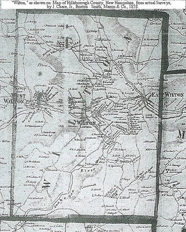
1858 Map of Wilton, Hillsborough County, New Hampshire
On June 18, 1761, the following petition was addressed to Governor Benning
Wentworth:
PETITION FOR INCORPORATION.
To HIs Excellency.
Benning Wentworth, Esq., Governor, & c., in the Province of New
Hampshire, and the Honorable His Majesty's Council of said Province:
The petition of us the subscribers being Inhabitants of a tract of
Land in said Province of the contents of five miles square called and
known by the name of Number 2, which Township bounds northerly on
Lyndeborough, westerly and Southerly on Peterborough Slip and Number 1,
Easterly on ye Masons Grant not taken up; which Tract of land is
considerably settled and improved, and is this year Taxed to the
Province with other towns.
We would therefore Humbly request of
your Excell'y and Honors that we may be Incorporated into a Township and
be invested with such Privileges and Immunities as other Towns have and
do enjoy in this Province, for ye more easy carrying on our Public
affairs & c. and that the said Corporation may be Bounded according to
the Grant of the said Township and your Petitioners as in duty bound
will ever pray, & c. June 18, 1761.
James Mann. Henry Snow. John
Cram. William Gibson. Jonathan Stevens. William Kinkeid. Haezial
Hamblet. William Mansur. Elexander Milieen. Robert Smith. John Dale.
William Vance. John Burton. Robert Renker. Philip Putnam. David
Barker. Ebenezer Perry. John Davidson. Jonathan Greele. Benjamin
Thompson. Hugh Smylie.
Samuel Mansur. Jacob Putnam.
The prayer of the petitioners was granted, the lands were surveyed, and the town
was incorporated June 25, 1762, under the name of Wilton, derived from
an ancient borough in Wiltshire, England. This act of incorporation was
to continue in force till January 1, 1765. The first town meeting was
held June 27, 1762. A second act of incorporation was granted January 2,
1765, signed by Hon. Benning Wentworth, Governor of the Province of New
Hampshire, "to have continued until HIs Majesty's pleasure shall be
further known." As His Majesty and His Majesty's successors have, so far
as is known, taken no exception to it, it is presumed this act of
incorporation remains valid to the present day.
ADDITION OF PART
OF WILTON TO TEMPLE.
In 1768 a petition was addressed to the
Governor and Council by the inhabitants of Peterborough Slip, Slipton or
Sliptown, the part of Peterborough lying east of the mountains called
Pack or Petit Monadnock, to have one mile of the west part of Wilton,
and extending the length of the town five miles, added to Peterborough
Slip to form an independent town. To compensate for this slice of a mile
wide being taken off of Wilton, the petitioners also prayed that one
mile wide of territory might be added to the town on the east. The
people of Wilton addressed the authorities with a counter-petition
asking that Peterborough Slip itself might be added to Wilton, and
deprecating any addition on the east. But the petitioners of the
Peterborough Slip prevailed over the Wiltonians, and a tract, half a
mile wide and five miles long, was taken from Wilton and added to
Peterborough Slip, constituting the town of Temple.
Thus after
all these changes of names and boundaries, of Salem-Canada, "Number
Two," Wilton five miles square, and Wilton four and a half miles wide by
five miles long, as at present constituted, we have the proprietary and
territorial history of the town of Wilton up to the present time.
Printed Resources:
1 Hurd, D. Hamilton. (Supervisor of
Compilation). History of Hillsborough County, New Hampshire.
Philadephia: J. W. Lewis & Co. 1885.
2 Map of Hillsborough
County, New Hampshire, from actual Surveys, by J. Chace, Jr. Boston:
Smith, Mason & Co., 1858.
3 Abiel Abbot Livermore and Sewall
Putnam. (Authors). History of the Town of Wilton, Hillsborough County,
New Hampshire. Lowell, Mass.: Marden & Rowell Printers, 1888.
Hillsborough County NHGenWeb Copyright
Design by Templates in Time
This page was last updated 12/25/2023