
Roads
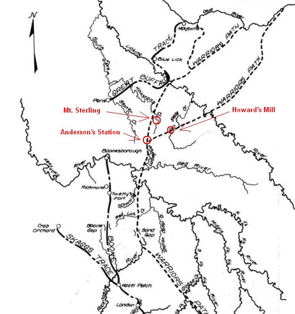
Warrior's Path
The first route through this area was the Warrior's Path. It was part of a network of trails that had been used by Native Americans for centuries. This particular section ran between the Cumberland Gap to the south and Ohio to the north.
The trail forked in Montgomery County near the headwaters of the Hinkston and Lulbegrud Creeks. This is where Nicholas Anderson patented his land in 1779 and built his station in 1791. From there one trail went northward through present day Mt. Sterling and on through Blue Lick at the Licking River. The other fork went northeast crossing Slate Creek at Howard's Mill and then on across the Licking River and up into Ohio.
More about the Warrior's Path can be found at this link: A History of the Daniel Boone Forest.
Ironworks Road
The first road of significance built by early settlers in Montgomery County was the Iron Works Road. It was built for the purpose of shipping finished iron products from Jacob Myers iron furnace on Slate Creek just south of today's Owingsville on west through Mount Sterling, Winchester and Paris to the Kentucky River at Frankfort.
Jacob Myers had patented his land there in 1782 and built the iron furnace in 1791. The furnace went into operation in 1792. Included with the land patented by Jacob Myers was Mud Lick Spring.
The mineral springs there soon became a well known attraction. William Ramsey built a boarding house and cabins at Mud Lick Spring in 1796 advertising 8 different springs at the location.
Henry Clay's father-in-law Col. Thomas Hart acquired Mud Lick Spring in 1800 and changed the name to Olympian Springs. In 1803, John Kennedy a Lexington Resident established Kentucky's first stage coach line. It ran the 47 miles between Lexington and Mud Lick Spring following the same route as the above mentioned Iron Works Road. A post office opened there in 1811.
The First Stage Coach Line
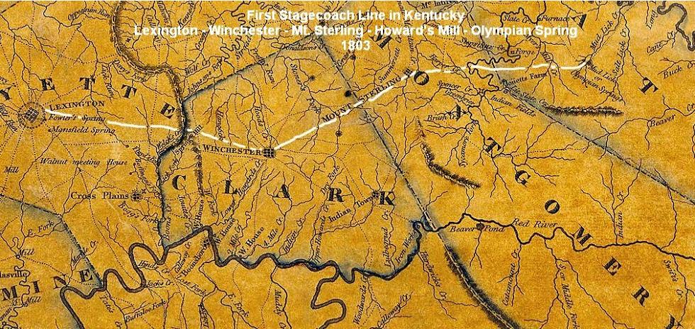
The barely visible dotted lines on Munsell's 1818 map show the roads of the day. The road between Lexington and Olympian Spring has been highlighted in white.
During the War of 1812, Col. Thomas Owings' 28th Regiment kept its camp at Olympian Springs.
The spring changed ownership several times during its long operation before finally closing in the early 1900s. The last buildings were razed in the 1950s.
The Pound Gap Road
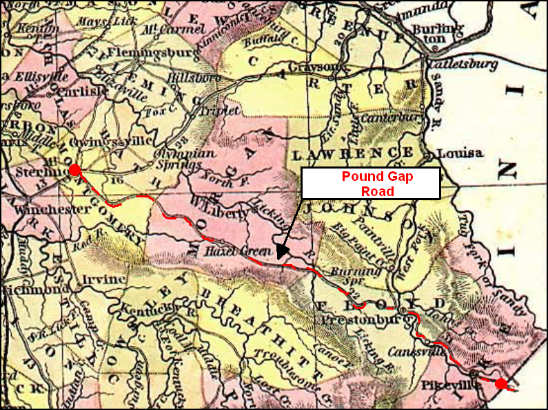
During the pre-Civil War period, the Mount Sterling-Pound Gap Road was Eastern Kentucky’s main highway. Horses, cattle and hogs raised in Central Kentucky were driven over the road to livestock markets in Abingdon, Lynchburg, and other Virginia towns, and it was also used by the Iron-Salt trade. Originally a series of Indian trails, it was maintained and improved at state expense by local contractors using picks and shovels and horse-drawn graders.
The first survey of the road was authorized in 1817. It began at Mt. Sterling, Kentucky, and extended southeast through Hazel Green, Licking Station, Prestonsburg, Laynesville and Pikeville to the Virginia State Line at Pound Gap. Horses, cattle and hogs raised in Central Kentucky were driven over the road to livestock markets in Abingdon, Lynchburg, and other Virginia towns, and it was also used by the Iron-Salt trade. Freighters using wagons drawn by oxen carried salt from the salt mines in Saltville, Virginia to markets in Central Kentucky and returned to Virginia carrying iron ingots smelted in the Bath County ironworks.
The state appropriated $2,700 for the road in 1824 and $23,000 in 1836, $8,000 of which was spent on the most rugged section of the road, the section extending from Pikeville to Pound Gap. The contractor who improved this section was Thomas May of Pike County, brother of Floyd County politician Samuel May and owner of a large farm on Shelby Creek.
During the War Between the States, the road served as the main thoroughfare for troops moving between Central Kentucky and Eastern Kentucky. In the days preceding the Battle of Middle Creek, after vacating their trenches at Hager Hill, Marshall’s four regiments marched up the Prestonsburg Road to the mouth of Abbott Creek, where that road intersected the Pound Gap Road. Then they moved up Abbott Creek on the Pound Gap Road and over the ridge to this location, the Forks of Middle Creek, which was traversed by an alternate route of the Pound Gap Road.
Marshall decided to make his stand at the Forks for several reasons. He had received intelligence that Cranor’s 40th Ohio was moving east from Licking Station to reinforce Garfield. He also knew, of course, that Garfield was pursuing him from Paintsville. By placing his army at the Forks of Middle Creek, Marshall was in a position to intercept Cranor’s force if it advanced east along the Pound Gap Road and Garfield’s force if it advanced west along the Pound Gap Road from the mouth of Middle Creek.
The position also afforded him a victory route and an escape route. If victorious, he could move his army via the Pound Gap Road into Central Kentucky. If defeated, he could escape by way of the road leading up the Left Fork of Middle Creek. As things turned out, he was forced to retreat from the position using the latter road. Marshall retreated through modern-day Goodloe and Pyramid, over Brushy Mountain, and down Brush Creek to Hueysville, where he established a camp at the Joseph Gearheart Farm.
Tradition says that his men burned all the fence posts on the farm in order to keep themselves warm. An unidentified Confederate soldier died of his wounds during the encampment and was subsequently buried in the Gearheart Cemetery. After camping for a week at Hueysville, Marshall moved his men farther up Right Beaver Creek to Martin’s Mill (modern-day Wayland), where they received a warm welcome from Confederate loyalist Johnny Martin, the neighborhood’s largest landowner.
source: Samuel May House Archive
Contacts

| Marvin Allen |
| Suzanne Shephard |
| Jeff Kemp |