
County History
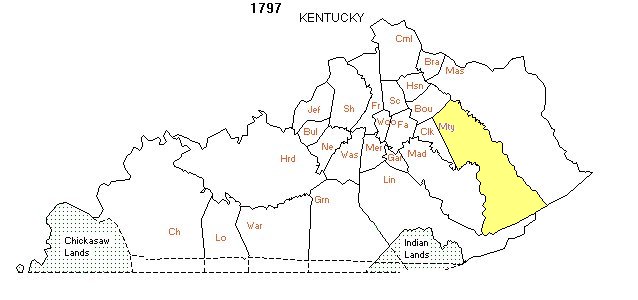
Montgomery
County is
located in the Outer Bluegrass Region at the intersection of I-64 and
US 460. The largest city is Mount Sterling, with a population of 7,113.
Montgomery County was formed by an act of the Kentucky General
Assembly December 14, 1796 with an effective date of March 1, 1797. It
was named for Gen. Richard Montgomery who was killed at the Battle of
Quebec during the Revolutionary War.
"SECTION 1. BE it enacted by the General Assembly, that from and after
the first day of March next, all that part of the county of Clark lying
northwardly and eastwardly of the following bounds, to wit: Beginning
on the Bourbon line at a red oak tree marked CL on the side of the road
leading from Mount Sterling to Paris, thence a straight line to strike
the dividing ridge between Hingstons and Stoners waters where the road
leading from Winchester to Mount Sterling crosses said ridge, thence
the same course continued crossing Red River until it strikes the
Kentucky River, shall be one distinct county and called and known by
the name of Montgomery." Reference: Microfilm Roll #2 -
Governor Isaac Shelby: Enrolled Bills for 1793, 1794 & 1796.
When it was formed, Montgomery
County was much larger than today being bounded on the east by the Licking River and the
Kentucky River to the west and south. The new county extended southeast
nearly to the tip of Virginia encompassing approximately 2,500 sq.
miles. In contrast, today's Montgomery County is 199 sq. miles.
Researchers will need to check Montgomery's parent counties for events
prior to 1797; Clark Co. 1793-1796, Bourbon Co. (VA)
1786-1792, Fayette
Co. (VA) 1780-1785 and Kentucky Co. (VA) 1777-1779 and Fincastle
Co. (VA) 1772-1776.
Effective 1800, Floyd Co. acquired
the large southern portion of Montgomery Co., and in 1811 Bath Co. was
formed from the eastern portion of Montgomery Co.
In 1816 Estill Co. acquired a
southwest section of Montgomery Co. with Floyd Co. acquiring a small
southern section in 1818. In 1852 a large part of Powell Co. was formed from the
remaining southern section. Finally in 1869, part of Menifee Co. was formed from
the southeastern section of Montgomery Co.
It is always a good idea to check county formation approval dates
versus effective dates to determine what records may be available.
The records for any events that took place within the bounds of older
Montgomery County boundaries are retained at the Mt. Sterling
courthouse. For example, any deeds prior to 1811 for land now in Bath
County will be found in Montgomery County.
More Montgomery County History can be found in the archives.
Contacts

| Marvin Allen |
| Suzanne Shephard |
| Jeff Kemp |