The Mountain Eagle
WHITESBURG, LETCHER COUNTY, KENTUCKY.
What was town like in earlier times?
Morehead State University
 |
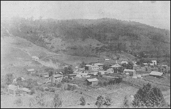
This view of Whitesburg looking east was taken by Albert R. Crandall, thought to be a geologist for the Kentucky Geological Survey, who didn't even need a wide-angle lense to get the whole town in his picture. There was more cropland than buildings in what is now Whitesburg when Crandall made the photo, probably sometime around 1890. The building at right center is the courthouse and the building on the hill at the left is the Presbyterian Church. (Photo courtesy of the Filson Club.) |
![]() Fortunately there are other alternatives. During the 1930's the Soil Conservation Service flew over most of Eastern Kentucky and took aerial photographs. The most striking thing one notices when comparing those images with similar shots is the greater amount of land in crops during those depressed times and the poorer quality of those photographs taken a third of a century ago. Regrettably, the quality is too poor for newspaper publication. Those copies we had made from the original negatives in the National Archives, Washington, D. C., are filed in the Camden-Carroll Library's Appalachian Collection at Morehead State University; if you are curious and would like to examine them, you are welcome to look at them the next time you are on the Morehead campus. A number of counties, primarily Eastern, were not photographed. The counties not photographed in the 30's are Floyd, Harlan, Johnson, Knott, Lawrence, Leslie, Letcher, Martin, Perry and Pike in the east, and Crittenden, Livingston and Lyon in the West.
Fortunately there are other alternatives. During the 1930's the Soil Conservation Service flew over most of Eastern Kentucky and took aerial photographs. The most striking thing one notices when comparing those images with similar shots is the greater amount of land in crops during those depressed times and the poorer quality of those photographs taken a third of a century ago. Regrettably, the quality is too poor for newspaper publication. Those copies we had made from the original negatives in the National Archives, Washington, D. C., are filed in the Camden-Carroll Library's Appalachian Collection at Morehead State University; if you are curious and would like to examine them, you are welcome to look at them the next time you are on the Morehead campus. A number of counties, primarily Eastern, were not photographed. The counties not photographed in the 30's are Floyd, Harlan, Johnson, Knott, Lawrence, Leslie, Letcher, Martin, Perry and Pike in the east, and Crittenden, Livingston and Lyon in the West.
 |
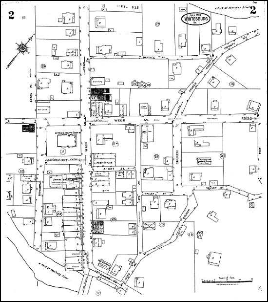
This 1927 map of Whitesburg, prepared by the Sanford {Sanborn} Map Company for insurance purposes, shows how some things have changed in town. When the map was made, City Hall was located in the space on Webb Avenue next to the Cozy Corner (a bank then occupied the Cozy Corner space), and the post office was in the space now occupied by Collins Florist. There was a boarding house on West Main Street between Webb and Bentley avenues and the Presbyterian Church was still on the hill above Church Street. Several downtown buildings were marked as being used for "hay storage." The Daniel Boone Hotel was new, and there was another hotel on the Kentucky River bank where DeVaughn's Jewel Box is now. The movie was a few doors up Main Street in the building now occupied by Quillen Drug. And there was still a lot of vacant space in town |
![]() Despite the poor quality of the photographs, or in some cases the lack of aerial shots, there is still another way to see your town in many cases. The Sanborn Map Company produced its first Eastern Kentucky insurance map in 1884. Towns in the "Kentucky Yesterdays" region that were first surveyed in the 1880's include Vanceburg, 1884; Owingsville, 1886; Catlettsburg, 1885; Flemingsburg, 1886; Mount Sterling, 1886; and Maysville, 1886. New additions by 1910 included Jackson, 1897; Paintsville, 1910; Louisa, 1907; Pikeville, 1910, and Morehead, 1908. Later still were the first insurance maps for Grayson, 1929; Olive Hill, 1920; Prestonsburg, 1926; Hazard, 1920, and Whitesburg, 1927. Especially for those towns whose first Sanborn map is of an early vintage, there tends to be a series of maps before 1930, each showing individual structures. This is an extremely valuable tool for dating buildings or photographs. Because the shapes of the buildings are shown, you can tell when grandma Myrna was able to get her husband to add that porch or to put a wing on the house, perhaps within five years or so. Copies of the pre-1930 maps have been donated to the University of Kentucky's Map Collection. The map that accompanies this article is from this collection and is reprinted through special one-time permission of the Sanborn Map Company, which still prints similar plats. Different colors on the maps indicate the material used in the construction of each building, and there is additional information of value to individuals writing fire insurance policies. Some buildings are listed by name or by type of business and you may be able to remember-or if you are not old enough, to help someone else remember-what the town was like in yesteryears by seeing that the furniture store was on the corner next to the hotel next to a drygoods store, and so on. Local historical societies might want to see if they can obtain outdated or no longer used Sanborn maps from local firms that have been in business a long time.
Despite the poor quality of the photographs, or in some cases the lack of aerial shots, there is still another way to see your town in many cases. The Sanborn Map Company produced its first Eastern Kentucky insurance map in 1884. Towns in the "Kentucky Yesterdays" region that were first surveyed in the 1880's include Vanceburg, 1884; Owingsville, 1886; Catlettsburg, 1885; Flemingsburg, 1886; Mount Sterling, 1886; and Maysville, 1886. New additions by 1910 included Jackson, 1897; Paintsville, 1910; Louisa, 1907; Pikeville, 1910, and Morehead, 1908. Later still were the first insurance maps for Grayson, 1929; Olive Hill, 1920; Prestonsburg, 1926; Hazard, 1920, and Whitesburg, 1927. Especially for those towns whose first Sanborn map is of an early vintage, there tends to be a series of maps before 1930, each showing individual structures. This is an extremely valuable tool for dating buildings or photographs. Because the shapes of the buildings are shown, you can tell when grandma Myrna was able to get her husband to add that porch or to put a wing on the house, perhaps within five years or so. Copies of the pre-1930 maps have been donated to the University of Kentucky's Map Collection. The map that accompanies this article is from this collection and is reprinted through special one-time permission of the Sanborn Map Company, which still prints similar plats. Different colors on the maps indicate the material used in the construction of each building, and there is additional information of value to individuals writing fire insurance policies. Some buildings are listed by name or by type of business and you may be able to remember-or if you are not old enough, to help someone else remember-what the town was like in yesteryears by seeing that the furniture store was on the corner next to the hotel next to a drygoods store, and so on. Local historical societies might want to see if they can obtain outdated or no longer used Sanborn maps from local firms that have been in business a long time.
![]() Except for the names of business and giving you an idea as to the physical shape of the town, the maps do little to populate your towns. Here there is another source-directories. In a few cases there are nineteenth century directories - Maysville beginning in 1861 and Ashland in 1891 - but for the most part one is dependent upon Kentucky State Directories. These tend to list perhaps 20 per cent of the town's adult male population, emphasizing lawyers and store owners. The first state directory for Kentucky was published just before the outbreak of the War Between the States. Many of the family names may still be familiar today. Such directories by various publishers were produced quite regularly (every few years) between then and 1906. Maps and directories are a few of the sources from which local history can be recovered.
Except for the names of business and giving you an idea as to the physical shape of the town, the maps do little to populate your towns. Here there is another source-directories. In a few cases there are nineteenth century directories - Maysville beginning in 1861 and Ashland in 1891 - but for the most part one is dependent upon Kentucky State Directories. These tend to list perhaps 20 per cent of the town's adult male population, emphasizing lawyers and store owners. The first state directory for Kentucky was published just before the outbreak of the War Between the States. Many of the family names may still be familiar today. Such directories by various publishers were produced quite regularly (every few years) between then and 1906. Maps and directories are a few of the sources from which local history can be recovered.
![]() The "Kentucky Yesterdays" project covers a twenty-three county area. Part of the concept of this Kentucky Humanities Council supported program is to bring home to the county of origin information relating to their history so that local individuals and institutions interested in their heritage might carry forward research into their past for the benefit of us all.
The "Kentucky Yesterdays" project covers a twenty-three county area. Part of the concept of this Kentucky Humanities Council supported program is to bring home to the county of origin information relating to their history so that local individuals and institutions interested in their heritage might carry forward research into their past for the benefit of us all.
(Editor's Note: Stewart Seely Sprague of Morehead State University produces this column of local history, "Kentucky Yesterdays," under a grant from the Kentucky Humanities Council.)
399 friendly folk and 1 grouch
"WHITESBURG. The judicial seat of Letcher County, is an incorporated town,
located on north fork of Kentucky river, 275 miles southeast of Louisville,
and 38 from Norton, Virginia, the nearest railroad approach.  Population 400.
J. N. McCrary, postmaster.

Adams J W, lawyer.
Adams Spencer, justice.
Adams S R, lawyer.
Adams Wm., photographer.
Baker S E, lawyer.
Bentley R B, county clerk.
Blair J A, lawyer.
Blair Robert, county attorney.
Blair Wm H, county judge.
Brashears Minerva, hotel.
Caudill J D, hotel.
Caudill & Long, flour mill.
Collins James, coal.
Collins John W, genl store.
Combs S, sheriff.
Craft J A, circuit court.
Craft Nehemiah, carpenter.
Fairchild S C, surveyor.
Fairchild S G, county surveyor.
Fields D D, hotel and lawyer.
Fields Ira, lawyer.
Fitzpatrick J B, lawyer.
Frazier J H, general store.
Gilly John, shoemaker.
Hale Lee, carpenter.
Hogg W W, boarding house.
Holbrooks Benjamin, blacksmith.
Holcomb David, flour and saw mill.
Kilgore N, lawyer.
Lewis Bros., general store.
Long W W, cabinet maker.
Lynn S C, lawyer.
McCrary G H, physician.
McCrary Joseph N, Physician; Medical Referee and
   Member Local Board of Health for Letcher County.
Marrs J P, general store.
May S H, lawyer.
Prichard J C, stage line.
Thompson J N, coal.
Tyree S C, lawyer.
Webb B M, lawyer and distiller.
Webb D W, hotel.
Wright S J, saw mill.
Source: 1896 State Directory.
Return to
Letcher County, KY, Genealogy
Home Page